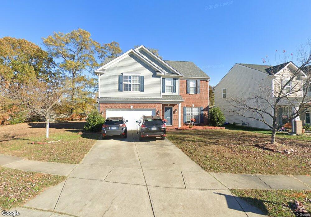
4304 Lawrence Daniel Dr Matthews, NC 28104
Estimated Value: $414,000 - $479,000
3
Beds
3
Baths
2,247
Sq Ft
$198/Sq Ft
Est. Value
About This Home
This home is located at 4304 Lawrence Daniel Dr, Matthews, NC 28104 and is currently estimated at $445,741, approximately $198 per square foot. 4304 Lawrence Daniel Dr is a home located in Union County with nearby schools including Stallings Elementary School, Porter Ridge Middle School, and Porter Ridge High School.
Ownership History
Date
Name
Owned For
Owner Type
Purchase Details
Closed on
Aug 31, 2011
Sold by
Whitfield Denise
Bought by
Peoples Bank
Current Estimated Value
Home Financials for this Owner
Home Financials are based on the most recent Mortgage that was taken out on this home.
Original Mortgage
$8,000
Outstanding Balance
$5,413
Interest Rate
4.24%
Mortgage Type
Stand Alone Second
Estimated Equity
$440,328
Purchase Details
Closed on
Jun 20, 2011
Sold by
Peoples Bank
Bought by
General Kathryn M
Home Financials for this Owner
Home Financials are based on the most recent Mortgage that was taken out on this home.
Original Mortgage
$118,907
Interest Rate
4.25%
Mortgage Type
FHA
Purchase Details
Closed on
Dec 23, 2010
Sold by
G & A Development Llc
Bought by
Peoples Bank
Purchase Details
Closed on
Apr 30, 2010
Sold by
Whitfield Deise
Bought by
G & A Development Llc
Purchase Details
Closed on
Nov 14, 2008
Sold by
G & A Development Llc
Bought by
Whitfield Denise
Home Financials for this Owner
Home Financials are based on the most recent Mortgage that was taken out on this home.
Original Mortgage
$177,400
Interest Rate
5.89%
Mortgage Type
Seller Take Back
Purchase Details
Closed on
Jan 4, 2008
Sold by
Grillo Jeffrey J and Grillo Anna
Bought by
G & A Development Llc
Home Financials for this Owner
Home Financials are based on the most recent Mortgage that was taken out on this home.
Original Mortgage
$167,200
Interest Rate
6.15%
Mortgage Type
Unknown
Purchase Details
Closed on
Dec 29, 2005
Sold by
The Ryland Group Inc
Bought by
Grillo Jeffrey J and Grillo Anna
Home Financials for this Owner
Home Financials are based on the most recent Mortgage that was taken out on this home.
Original Mortgage
$75,000
Interest Rate
6.28%
Mortgage Type
Fannie Mae Freddie Mac
Purchase Details
Closed on
Jan 19, 2005
Sold by
Woodbridge At Stallings Lp
Bought by
The Ryland Group Inc
Create a Home Valuation Report for This Property
The Home Valuation Report is an in-depth analysis detailing your home's value as well as a comparison with similar homes in the area
Home Values in the Area
Average Home Value in this Area
Purchase History
| Date | Buyer | Sale Price | Title Company |
|---|---|---|---|
| Peoples Bank | -- | None Available | |
| General Kathryn M | $122,000 | None Available | |
| Peoples Bank | $145,000 | None Available | |
| G & A Development Llc | $183,537 | None Available | |
| Whitfield Denise | $207,500 | None Available | |
| G & A Development Llc | $208,500 | None Available | |
| Grillo Jeffrey J | $173,000 | None Available | |
| The Ryland Group Inc | $31,000 | -- |
Source: Public Records
Mortgage History
| Date | Status | Borrower | Loan Amount |
|---|---|---|---|
| Open | Peoples Bank | $8,000 | |
| Previous Owner | General Kathryn M | $118,907 | |
| Previous Owner | Whitfield Denise | $177,400 | |
| Previous Owner | G & A Development Llc | $167,200 | |
| Previous Owner | Grillo Jeffrey J | $75,000 |
Source: Public Records
Tax History Compared to Growth
Tax History
| Year | Tax Paid | Tax Assessment Tax Assessment Total Assessment is a certain percentage of the fair market value that is determined by local assessors to be the total taxable value of land and additions on the property. | Land | Improvement |
|---|---|---|---|---|
| 2025 | $2,840 | $414,300 | $0 | $0 |
| 2024 | $2,433 | $275,900 | $55,000 | $220,900 |
| 2023 | $2,334 | $275,900 | $55,000 | $220,900 |
| 2022 | $2,313 | $275,900 | $55,000 | $220,900 |
| 2021 | $2,312 | $275,900 | $55,000 | $220,900 |
| 2020 | $1,916 | $186,900 | $37,500 | $149,400 |
| 2019 | $1,908 | $186,900 | $37,500 | $149,400 |
| 2018 | $1,908 | $186,900 | $37,500 | $149,400 |
| 2017 | $1,956 | $186,900 | $37,500 | $149,400 |
| 2016 | $1,974 | $186,900 | $37,500 | $149,400 |
| 2015 | $1,994 | $186,900 | $37,500 | $149,400 |
| 2014 | $1,350 | $190,770 | $32,500 | $158,270 |
Source: Public Records
Map
Nearby Homes
- 4324 Stallingswood Dr
- 4023 Lawrence Daniel Dr
- 3017 Stevens Schultz Ln
- 4006 Scarlet Dr Unit 29
- 5401 Stevens Mill Rd
- 5419 Stevens Mill Rd
- 15108 Castlebridge Ln
- 14601 Phillips Rd
- 1830 Light Brigade Dr Unit v512
- 2126 Blue Iris Dr
- 5033 Haven Lodge Rd
- 16020 Clear Creek Farm Rd
- 14818 Hooks Rd
- 2544 Mount Harmony Church Rd
- 201 Limerick Dr
- 14027 Hackamore Dr
- 14200 Springwater Dr
- 844 Clonmel Dr
- 315 Tamarack Dr
- 14348 Brooks Knoll Ln
- 4300 Lawrence Daniel Dr
- 502 Caroline Aubrey Way
- 4230 Lawrence Daniel Dr
- 4000 Lawrence Daniel Dr
- 4514 Lawrence Daniel Dr
- 602 Caroline Aubrey Way
- 4228 Lawrence Daniel Dr
- 4002 Lawrence Daniel Dr
- 4002 Lawrence Daniel Dr Unit 14
- 4001 Lawrence Daniel Dr
- 4004 Lawrence Daniel Dr
- 4003 Lawrence Daniel Dr
- 4405 Lawrence Daniel Dr
- 4225 Lawrence Daniel Dr
- 4005 Lawrence Daniel Dr
- 4407 Lawrence Daniel Dr
- 4223 Lawrence Daniel Dr
- 4404 Lawrence Daniel Dr
- 603 Caroline Aubrey Way Unit 22
- 4008 Lawrence Daniel Dr