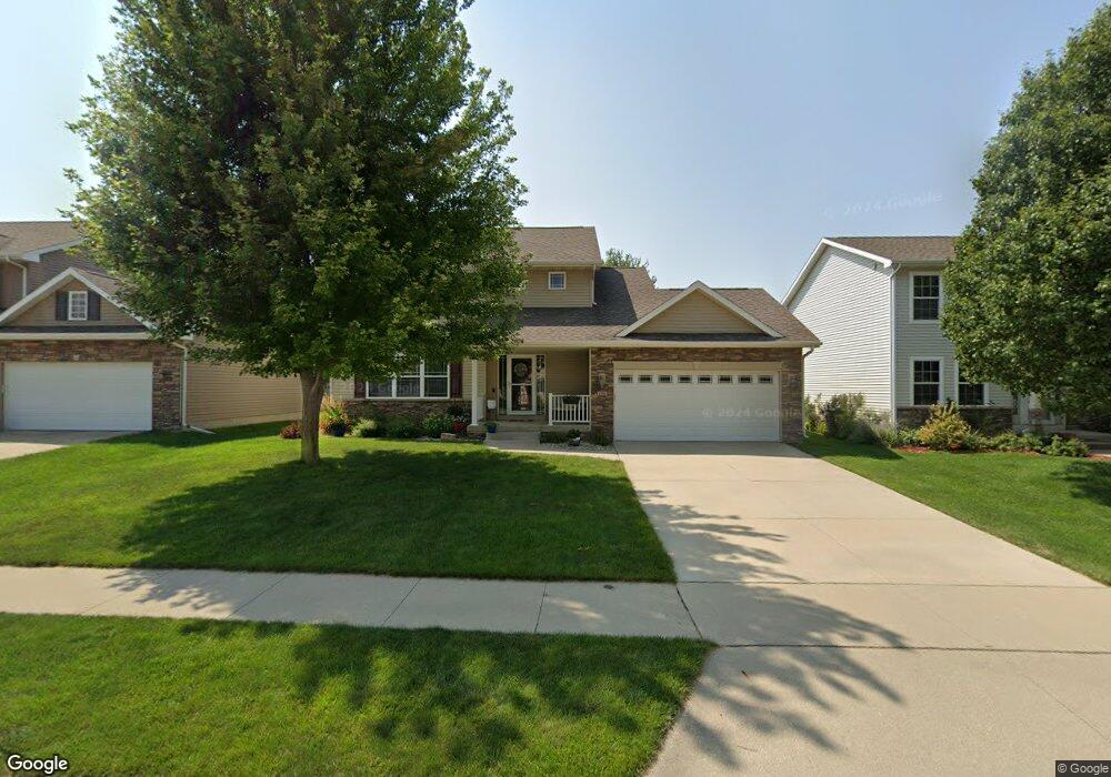
4308 132nd St Urbandale, IA 50323
Estimated Value: $392,000 - $409,000
3
Beds
2
Baths
1,669
Sq Ft
$240/Sq Ft
Est. Value
About This Home
This home is located at 4308 132nd St, Urbandale, IA 50323 and is currently estimated at $400,506, approximately $239 per square foot. 4308 132nd St is a home located in Polk County with nearby schools including Webster Elementary School, Urbandale Middle School, and Urbandale High School.
Ownership History
Date
Name
Owned For
Owner Type
Purchase Details
Closed on
Jun 3, 2008
Sold by
Vintage Custom Homes Llc
Bought by
Burkhart Gabriel A and Opatz Christine L
Current Estimated Value
Home Financials for this Owner
Home Financials are based on the most recent Mortgage that was taken out on this home.
Original Mortgage
$227,886
Outstanding Balance
$145,597
Interest Rate
6.05%
Mortgage Type
Purchase Money Mortgage
Estimated Equity
$254,909
Create a Home Valuation Report for This Property
The Home Valuation Report is an in-depth analysis detailing your home's value as well as a comparison with similar homes in the area
Home Values in the Area
Average Home Value in this Area
Purchase History
| Date | Buyer | Sale Price | Title Company |
|---|---|---|---|
| Burkhart Gabriel A | $239,000 | None Available |
Source: Public Records
Mortgage History
| Date | Status | Borrower | Loan Amount |
|---|---|---|---|
| Open | Burkhart Gabriel A | $227,886 |
Source: Public Records
Tax History Compared to Growth
Tax History
| Year | Tax Paid | Tax Assessment Tax Assessment Total Assessment is a certain percentage of the fair market value that is determined by local assessors to be the total taxable value of land and additions on the property. | Land | Improvement |
|---|---|---|---|---|
| 2025 | $6,398 | $386,300 | $70,400 | $315,900 |
| 2024 | $6,398 | $365,600 | $65,800 | $299,800 |
| 2023 | $5,956 | $365,600 | $65,800 | $299,800 |
| 2022 | $5,886 | $288,000 | $53,700 | $234,300 |
| 2021 | $6,076 | $288,000 | $53,700 | $234,300 |
| 2020 | $5,976 | $282,000 | $52,700 | $229,300 |
| 2019 | $5,890 | $282,000 | $52,700 | $229,300 |
| 2018 | $5,692 | $261,700 | $47,900 | $213,800 |
| 2017 | $5,350 | $261,700 | $47,900 | $213,800 |
| 2016 | $5,220 | $241,800 | $43,600 | $198,200 |
| 2015 | $5,220 | $241,800 | $43,600 | $198,200 |
| 2014 | $4,704 | $225,000 | $40,000 | $185,000 |
Source: Public Records
Map
Nearby Homes
- 12912 Hammontree Dr
- 4309 129th St
- 13114 Iltis Dr
- 4412 125th St
- 4111 140th St
- 4016 127th St
- 12510 Prairie Dr
- 12335 Tanglewood Dr
- 12527 Airline Ave
- 12515 Airline Ave
- 12723 Sunflower Dr
- 4143 122nd St
- 4523 143rd St
- 12324 Sunflower Dr
- 12220 Horton Ave
- 3935 122nd St
- 4602 143rd St
- 14327 Aurora Ave
- 14308 Hickory Dr
- 4737 144th St