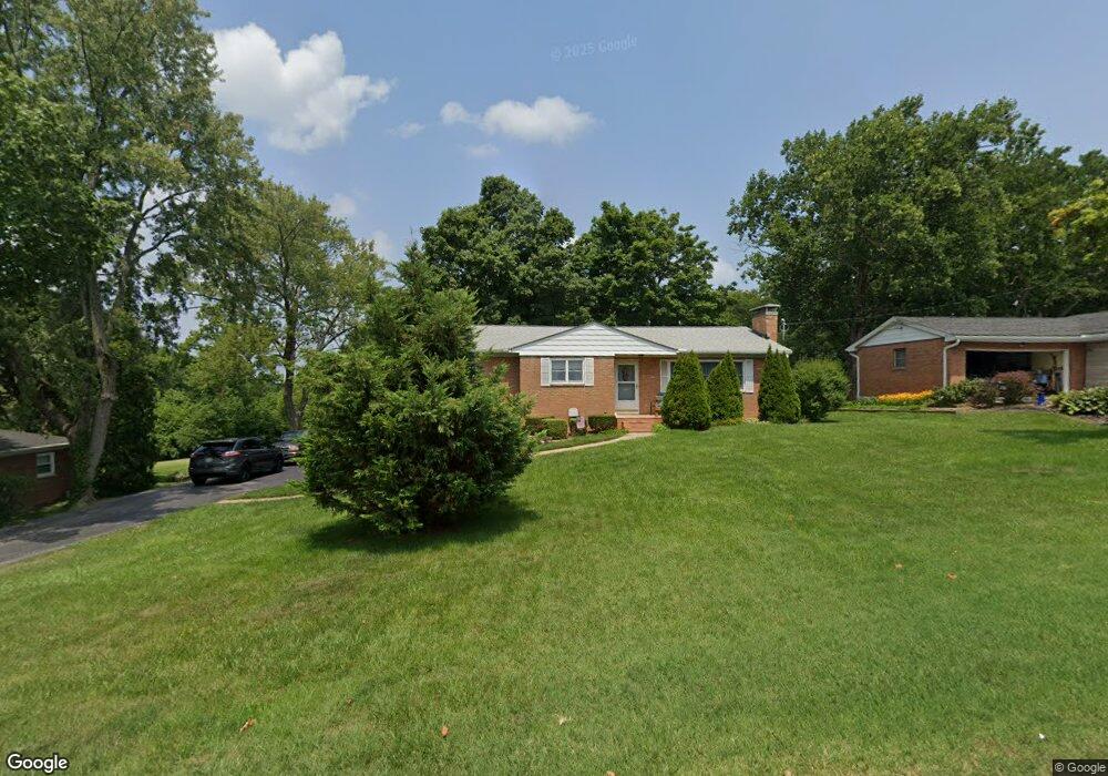
4309 Lisa Ln Middletown, OH 45042
Springhill NeighborhoodEstimated Value: $237,257 - $280,000
2
Beds
1
Bath
1,520
Sq Ft
$173/Sq Ft
Est. Value
About This Home
This home is located at 4309 Lisa Ln, Middletown, OH 45042 and is currently estimated at $263,064, approximately $173 per square foot. 4309 Lisa Ln is a home located in Butler County with nearby schools including Miller Ridge Elementary School, Highview 6th Grade Center, and Middletown Middle School.
Ownership History
Date
Name
Owned For
Owner Type
Purchase Details
Closed on
Aug 20, 2007
Sold by
Imhoff Eleanor
Bought by
Cole George W and Cole Debra R
Current Estimated Value
Home Financials for this Owner
Home Financials are based on the most recent Mortgage that was taken out on this home.
Original Mortgage
$136,500
Outstanding Balance
$86,292
Interest Rate
6.63%
Mortgage Type
Purchase Money Mortgage
Estimated Equity
$176,772
Create a Home Valuation Report for This Property
The Home Valuation Report is an in-depth analysis detailing your home's value as well as a comparison with similar homes in the area
Home Values in the Area
Average Home Value in this Area
Purchase History
| Date | Buyer | Sale Price | Title Company |
|---|---|---|---|
| Cole George W | $136,500 | Vantage Land Title Inc |
Source: Public Records
Mortgage History
| Date | Status | Borrower | Loan Amount |
|---|---|---|---|
| Open | Cole George W | $136,500 |
Source: Public Records
Tax History Compared to Growth
Tax History
| Year | Tax Paid | Tax Assessment Tax Assessment Total Assessment is a certain percentage of the fair market value that is determined by local assessors to be the total taxable value of land and additions on the property. | Land | Improvement |
|---|---|---|---|---|
| 2024 | $3,407 | $65,950 | $12,450 | $53,500 |
| 2023 | $3,386 | $62,310 | $12,450 | $49,860 |
| 2022 | $2,870 | $49,380 | $12,450 | $36,930 |
| 2021 | $2,760 | $49,380 | $12,450 | $36,930 |
| 2020 | $2,875 | $49,380 | $12,450 | $36,930 |
| 2019 | $2,839 | $39,170 | $11,970 | $27,200 |
| 2018 | $2,471 | $39,170 | $11,970 | $27,200 |
| 2017 | $2,475 | $39,170 | $11,970 | $27,200 |
| 2016 | $2,499 | $37,870 | $11,970 | $25,900 |
| 2015 | $2,462 | $37,870 | $11,970 | $25,900 |
| 2014 | $2,296 | $37,870 | $11,970 | $25,900 |
| 2013 | $2,296 | $38,440 | $15,560 | $22,880 |
Source: Public Records
Map
Nearby Homes
- 4430 Stratford Dr
- 4431 Stratford Dr
- 4205 Vannest Ave
- 1709 Berwick Ln
- 4235 Vannest Ave
- 2204 Hawthorne St
- 2310 Byron St
- 2316 Byron St
- 3512 Glencoe Ave
- 3504 Jewell Ave
- 4422 Riviera Dr
- 618 Quail Run Rd
- 4904 Timberline Dr Unit 84
- 4840 Shannon Way
- 408 N Marshall Rd
- 4822 Miller Rd
- 1031 Golfview Dr
- 4964 Timberline Dr Unit 81
- 2995 Carmody Blvd
- 3206 Bexley Dr