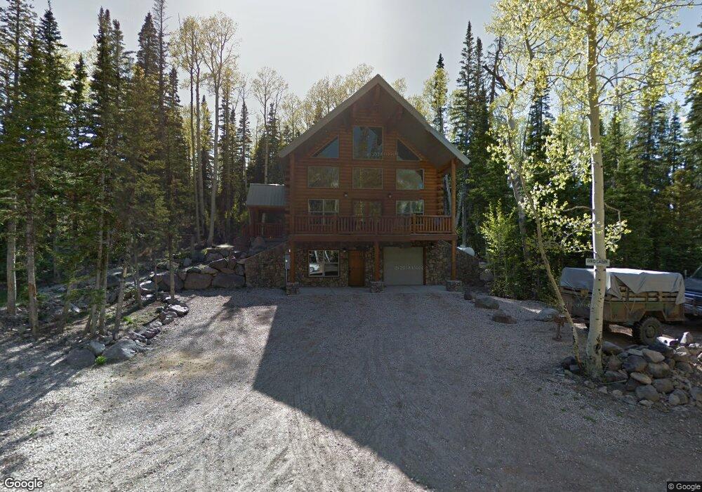
431 N 275 E Brian Head, UT 84719
Estimated Value: $671,351 - $854,000
5
Beds
3
Baths
2,618
Sq Ft
$289/Sq Ft
Est. Value
About This Home
This home is located at 431 N 275 E, Brian Head, UT 84719 and is currently estimated at $757,117, approximately $289 per square foot. 431 N 275 E is a home located in Iron County with nearby schools including Parowan School, Parowan High School, and Cedar City High School.
Ownership History
Date
Name
Owned For
Owner Type
Purchase Details
Closed on
Feb 11, 2020
Sold by
Davis Jay E and Davis Keri D
Bought by
Harpin Zachary
Current Estimated Value
Home Financials for this Owner
Home Financials are based on the most recent Mortgage that was taken out on this home.
Original Mortgage
$332,000
Outstanding Balance
$294,630
Interest Rate
3.72%
Mortgage Type
New Conventional
Estimated Equity
$462,487
Purchase Details
Closed on
Jun 21, 2007
Sold by
Amethyst Corp
Bought by
Bird Dennis William
Purchase Details
Closed on
Jun 11, 2007
Sold by
Gates Lorrina Lynn
Bought by
Amethyst Corp
Create a Home Valuation Report for This Property
The Home Valuation Report is an in-depth analysis detailing your home's value as well as a comparison with similar homes in the area
Home Values in the Area
Average Home Value in this Area
Purchase History
| Date | Buyer | Sale Price | Title Company |
|---|---|---|---|
| Harpin Zachary | -- | American First Escrow & Ttl | |
| Bird Dennis William | -- | -- | |
| Amethyst Corp | -- | -- |
Source: Public Records
Mortgage History
| Date | Status | Borrower | Loan Amount |
|---|---|---|---|
| Open | Harpin Zachary | $332,000 |
Source: Public Records
Tax History
| Year | Tax Paid | Tax Assessment Tax Assessment Total Assessment is a certain percentage of the fair market value that is determined by local assessors to be the total taxable value of land and additions on the property. | Land | Improvement |
|---|---|---|---|---|
| 2025 | $5,110 | $648,003 | $51,750 | $596,253 |
| 2023 | $5,121 | $691,440 | $51,750 | $639,690 |
| 2022 | $6,796 | $684,690 | $45,000 | $639,690 |
| 2021 | $4,852 | $488,835 | $15,000 | $473,835 |
| 2020 | $4,629 | $425,285 | $15,000 | $410,285 |
| 2019 | $4,413 | $374,905 | $15,000 | $359,905 |
| 2018 | $4,308 | $354,535 | $15,000 | $339,535 |
| 2017 | $4,330 | $354,535 | $15,000 | $339,535 |
| 2016 | $4,211 | $323,670 | $15,000 | $308,670 |
| 2015 | $3,650 | $261,415 | $0 | $0 |
| 2014 | $3,030 | $197,010 | $0 | $0 |
Source: Public Records
Map
Nearby Homes
- 211 E 475 N
- 391 N Falcon
- 370 Arrowleaf Dr
- 0 Falcon Ct Unit CBME unit c lots 68
- 349 Scenic Dr
- 429 N Aoki Michi Rd
- 380 N Forest Dr
- 79 N Forest Dr
- 0 Dr
- 322 N Aoki Michi Rd
- 327 N Aoki Michi Rd
- 321 N Rue Jolley Rd
- 310 Utah 143 Unit 9
- 235 E Snowman Dr
- 235 E Snowman Dr Unit 1
- 464 N Hwy 143 Unit a204
- 464 N Hwy 143 Unit A211
- 464 N Hwy 143 Unit 143 A213
- 464 N Hwy 143 Unit A308
- 464 N Hwy 143 #A211
- 431 N 450 E
- 452 N 275 E Cbme U-C
- 452 N 275 E Cbme U-C Unit 58
- 264 E 475 N Unit CBME unit C lot 55
- 340 E 475 N Unit Lot 54 CBME A
- 360 E 475 N Unit Lot 53 CBME A
- 264 E 475 N Unit C
- 340 E 475 N Unit A
- 360 E 475 N Unit A
- 264 E 475 N
- 384 N 275 E Cbme C-61
- 386 N Elk
- 405 Elk Dr Unit CBME UnC 89&90
- 405 Elk Dr
- 399 N 275 E Unit CBME unit C lot 116
- 248 N 275 E
- 230 N 275 E Unit CBME unit C lot 160
- 452 N 275 E
- 313 N 275 E Unit C
- 363 N 275 E Unit C
Your Personal Tour Guide
Ask me questions while you tour the home.