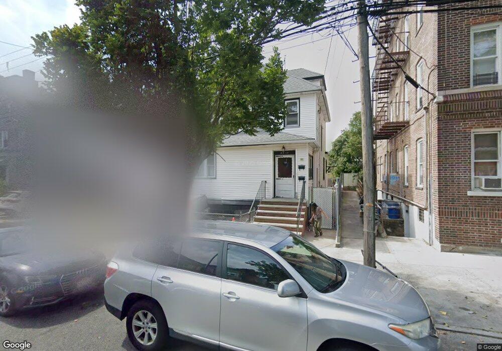
4312 165th St Flushing, NY 11358
East Flushing NeighborhoodEstimated Value: $1,253,000 - $1,627,000
Studio
--
Bath
2,811
Sq Ft
$498/Sq Ft
Est. Value
About This Home
This home is located at 4312 165th St, Flushing, NY 11358 and is currently estimated at $1,400,036, approximately $498 per square foot. 4312 165th St is a home located in Queens County with nearby schools including P.S. 107 Thomas A Dooley, I.S. 25 Adrien Block, and Francis Lewis High School.
Ownership History
Date
Name
Owned For
Owner Type
Purchase Details
Closed on
Jan 14, 2013
Sold by
Estate Of Marie Leonard
Bought by
Leonard Frank
Current Estimated Value
Home Financials for this Owner
Home Financials are based on the most recent Mortgage that was taken out on this home.
Original Mortgage
$390,000
Outstanding Balance
$271,295
Interest Rate
3.38%
Mortgage Type
Commercial
Estimated Equity
$1,128,741
Create a Home Valuation Report for This Property
The Home Valuation Report is an in-depth analysis detailing your home's value as well as a comparison with similar homes in the area
Home Values in the Area
Average Home Value in this Area
Purchase History
| Date | Buyer | Sale Price | Title Company |
|---|---|---|---|
| Leonard Frank | $585,000 | -- |
Source: Public Records
Mortgage History
| Date | Status | Borrower | Loan Amount |
|---|---|---|---|
| Open | Leonard Frank | $390,000 |
Source: Public Records
Tax History
| Year | Tax Paid | Tax Assessment Tax Assessment Total Assessment is a certain percentage of the fair market value that is determined by local assessors to be the total taxable value of land and additions on the property. | Land | Improvement |
|---|---|---|---|---|
| 2025 | $9,391 | $51,022 | $12,106 | $38,916 |
| 2024 | $9,403 | $48,154 | $12,452 | $35,702 |
| 2023 | $8,872 | $45,572 | $10,627 | $34,945 |
| 2022 | $8,296 | $81,420 | $21,240 | $60,180 |
| 2021 | $8,753 | $87,060 | $21,240 | $65,820 |
| 2020 | $8,704 | $85,860 | $21,240 | $64,620 |
| 2019 | $8,102 | $73,500 | $21,240 | $52,260 |
| 2018 | $7,444 | $37,977 | $10,738 | $27,239 |
| 2017 | $7,004 | $35,830 | $12,596 | $23,234 |
| 2016 | $6,853 | $35,830 | $12,596 | $23,234 |
| 2015 | $3,433 | $35,432 | $17,406 | $18,026 |
| 2014 | $3,433 | $33,440 | $19,129 | $14,311 |
Source: Public Records
Map
Nearby Homes
- 43-33 163rd St
- 43-58 163rd St
- 43-27 162nd St
- 163-02 45th Ave
- 4328 168th St
- 45-18 166th St
- 167-22 Northern Blvd
- 42-16 162nd St
- 4344 161st St
- 4363 160th St
- 4018 165th St
- 45-25 168th St
- 4012 166th St
- 45-74 164th St
- 16003 Sanford Ave
- 16001 Sanford Ave
- 45-57 160th St
- 36-40 167th St
- 42-28 159th St
- 4564 170th St
- 4316 165th St
- 43-16 165th St
- 43-16 165th St Unit 2Fl
- 43-24/26 165 St Unit 32
- 16418 43rd Ave
- 16412 43rd Ave
- 164-18 43rd Ave Unit C2
- 4320 165th St
- 16408 43rd Ave
- 4315 164th St
- 4317 164th St
- 16406 43rd Ave
- 43-15 164th St
- 4319 164th St
- 4324 165th St
- 43-24 165th St Unit 16
- 43-24 165th St
- 43-19 164th St
- 43-19 164th St Unit 1FL+BM
- 43-19 164th St Unit 1FL
Your Personal Tour Guide
Ask me questions while you tour the home.