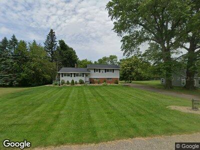
4316 Briar Hill St SW Massillon, OH 44646
Southeast Massillon NeighborhoodEstimated Value: $219,122 - $235,000
3
Beds
2
Baths
1,872
Sq Ft
$120/Sq Ft
Est. Value
About This Home
This home is located at 4316 Briar Hill St SW, Massillon, OH 44646 and is currently estimated at $225,531, approximately $120 per square foot. 4316 Briar Hill St SW is a home located in Stark County with nearby schools including Pfeiffer Intermediate School, Edison Middle School, and Perry High School.
Ownership History
Date
Name
Owned For
Owner Type
Purchase Details
Closed on
Aug 31, 2009
Sold by
Williams Phyllis A and Williams James Franklin
Bought by
Anthony Eric D and Anthony Andrea L
Current Estimated Value
Home Financials for this Owner
Home Financials are based on the most recent Mortgage that was taken out on this home.
Original Mortgage
$106,043
Outstanding Balance
$71,631
Interest Rate
5.21%
Mortgage Type
FHA
Estimated Equity
$142,267
Purchase Details
Closed on
Aug 11, 2003
Sold by
Estate Of Franklin D Williams
Bought by
Williams Phyllis A
Create a Home Valuation Report for This Property
The Home Valuation Report is an in-depth analysis detailing your home's value as well as a comparison with similar homes in the area
Home Values in the Area
Average Home Value in this Area
Purchase History
| Date | Buyer | Sale Price | Title Company |
|---|---|---|---|
| Anthony Eric D | $108,000 | Attorney | |
| Williams Phyllis A | -- | -- |
Source: Public Records
Mortgage History
| Date | Status | Borrower | Loan Amount |
|---|---|---|---|
| Open | Anthony Eric D | $6,033 | |
| Open | Anthony Eric D | $106,043 | |
| Previous Owner | Williams Franklin D | $101,000 |
Source: Public Records
Tax History Compared to Growth
Tax History
| Year | Tax Paid | Tax Assessment Tax Assessment Total Assessment is a certain percentage of the fair market value that is determined by local assessors to be the total taxable value of land and additions on the property. | Land | Improvement |
|---|---|---|---|---|
| 2024 | -- | $58,210 | $19,990 | $38,220 |
| 2023 | $2,599 | $44,700 | $14,980 | $29,720 |
| 2022 | $2,611 | $44,700 | $14,980 | $29,720 |
| 2021 | $2,757 | $44,700 | $14,980 | $29,720 |
| 2020 | $2,325 | $35,150 | $11,660 | $23,490 |
| 2019 | $2,132 | $35,150 | $11,660 | $23,490 |
| 2018 | $2,110 | $35,150 | $11,660 | $23,490 |
| 2017 | $2,062 | $31,650 | $9,660 | $21,990 |
| 2016 | $2,071 | $31,650 | $9,660 | $21,990 |
| 2015 | $2,086 | $31,650 | $9,660 | $21,990 |
| 2014 | $159 | $32,490 | $9,910 | $22,580 |
| 2013 | $1,038 | $32,490 | $9,910 | $22,580 |
Source: Public Records
Map
Nearby Homes
- 212 Westland Ave SW
- 3626 Hazelbrook St SW
- 130 Eden Ave NW
- 120 Leonard Ave NW
- 200 Stewart Ave NW
- 0 Clark St SW Unit 5126336
- 143 Highland Ave SW
- 229 Locke Ave NW
- 318 Locke Ave NW
- 134 Perry Dr NW
- 323 Harding Ave NW
- 2410 Perry Dr SW
- 331 - 333 Harding Ave NW
- 134 Shore Line Ave NW
- 337 Harding Ave NW
- 5106 Summitview Cir NW
- 1402 Channonbrook St SW Unit C5A
- 2580 Barnstone Ave SW Unit 2580
- 4838 Kendal St SW
- 5301 Oakvale St SW
- 4316 Briar Hill St SW
- 4324 Briar Hill St SW
- 4240 Briar Hill St SW
- 4400 Briar Hill St SW
- 0 Briar Hill St SW
- 1640 Westdale St SW
- 4410 Briar Hill St SW
- 4315 Briar Hill St SW
- 4325 Briar Hill St SW
- 4401 Briar Hill St SW
- 4420 Briar Hill St SW
- 1654 Westdale St SW
- 1641 Cedarcrest Ave SW
- 1655 Cedarcrest Ave SW
- 1655 Westdale Ave SW
- 1622 Cedarcrest Ave SW
- 4324 Southway St SW
- 1633 Westdale St SW
- 1633 Westdale St SW
- 1655 Westdale St SW