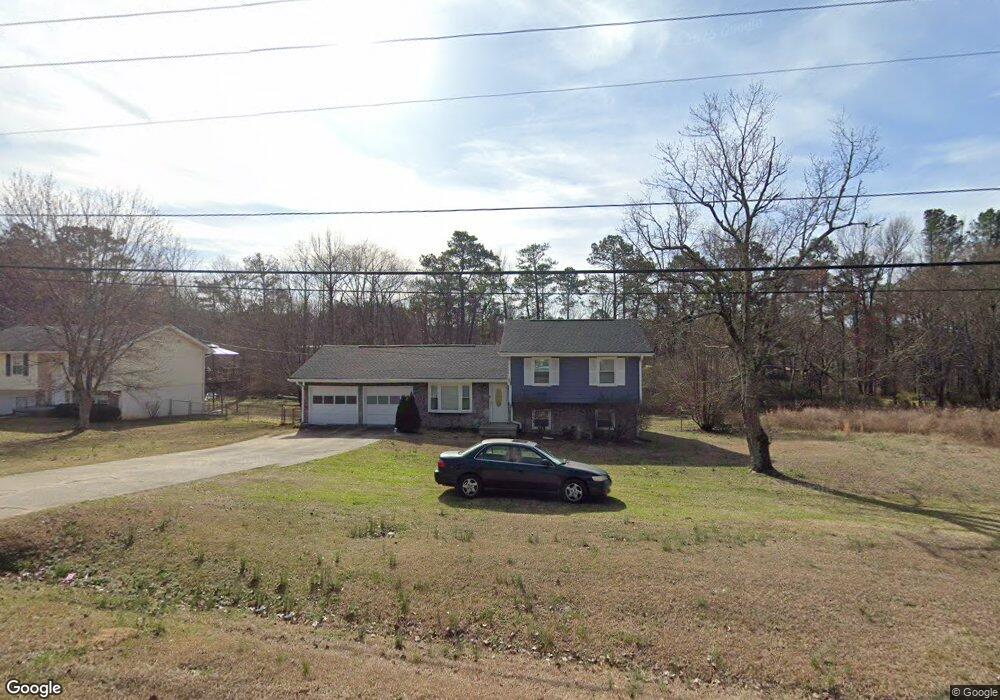
4317 Maroney Mill Rd Unit 2 Douglasville, GA 30134
Estimated Value: $201,000 - $275,000
4
Beds
3
Baths
956
Sq Ft
$245/Sq Ft
Est. Value
About This Home
This home is located at 4317 Maroney Mill Rd Unit 2, Douglasville, GA 30134 and is currently estimated at $234,497, approximately $245 per square foot. 4317 Maroney Mill Rd Unit 2 is a home located in Douglas County with nearby schools including Eastside Elementary School, Turner Middle School, and Lithia Springs Comprehensive High School.
Ownership History
Date
Name
Owned For
Owner Type
Purchase Details
Closed on
Aug 13, 1993
Sold by
Younce Michael P and Younce Marsha H
Bought by
Davis Lolita R
Current Estimated Value
Home Financials for this Owner
Home Financials are based on the most recent Mortgage that was taken out on this home.
Original Mortgage
$66,700
Interest Rate
7.24%
Mortgage Type
VA
Create a Home Valuation Report for This Property
The Home Valuation Report is an in-depth analysis detailing your home's value as well as a comparison with similar homes in the area
Home Values in the Area
Average Home Value in this Area
Purchase History
| Date | Buyer | Sale Price | Title Company |
|---|---|---|---|
| Davis Lolita R | $65,900 | -- |
Source: Public Records
Mortgage History
| Date | Status | Borrower | Loan Amount |
|---|---|---|---|
| Closed | Davis Lolita R | $66,700 |
Source: Public Records
Tax History Compared to Growth
Tax History
| Year | Tax Paid | Tax Assessment Tax Assessment Total Assessment is a certain percentage of the fair market value that is determined by local assessors to be the total taxable value of land and additions on the property. | Land | Improvement |
|---|---|---|---|---|
| 2024 | -- | $51,120 | $10,400 | $40,720 |
| 2023 | $0 | $51,120 | $10,400 | $40,720 |
| 2022 | $17,406 | $51,120 | $10,400 | $40,720 |
| 2021 | $14,846 | $43,600 | $10,400 | $33,200 |
| 2020 | $1,446 | $43,600 | $10,400 | $33,200 |
| 2019 | $0 | $42,280 | $10,400 | $31,880 |
| 2018 | $1,410 | $41,400 | $10,400 | $31,000 |
| 2017 | $0 | $37,360 | $10,400 | $26,960 |
| 2016 | -- | $36,440 | $10,400 | $26,040 |
| 2015 | -- | $35,280 | $10,400 | $24,880 |
| 2014 | -- | $33,200 | $10,400 | $22,800 |
| 2013 | -- | $33,320 | $10,400 | $22,920 |
Source: Public Records
Map
Nearby Homes
- 930 Terrace Mill Dr
- 771 N Burnt Hickory Rd
- 716 W Spring Dr
- 4113 Maroney Mill Rd
- 980 Bearden Rd
- 4751 Crinklepoint Ct
- 4170 Newman Ellis Rd
- 00 Boyd Rd
- 11411 Veterans Memorial Hwy
- 0 Scott Dr Unit 7532624
- 0 Scott Dr Unit 10468599
- 571 Bearden Rd
- 567 Bearden Rd
- 561 Bearden Rd
- 1134 Wagon Trace
- 4442 Lamar Dr
- 0 Mcintosh Rd Unit 7605889
- 426 N Burnt Hickory Rd
- 4037 Regent St
- 3948 Regent St
- 4307 Maroney Mill Rd
- 4327 Maroney Mill Rd
- 4297 Maroney Mill Rd
- 4297 Maroney Mill Rd Unit 4
- 4337 Maroney Mill Rd Unit 2
- 903 Westgard Ct Unit 6
- 903 Westgard Ct
- 4287 Maroney Mill Rd
- 900 Westgard Ct
- 4347 Maroney Mill Rd Unit 9
- 893 Westgard Ct
- 4334 Maroney Mill Rd
- 4277 Maroney Mill Rd
- 890 Westgard Ct
- 4344 Maroney Mill Rd
- 4354 Maroney Mill Rd
- 4345 Bridger Way
- 4267 Maroney Mill Rd
- 4355 Bridger Way