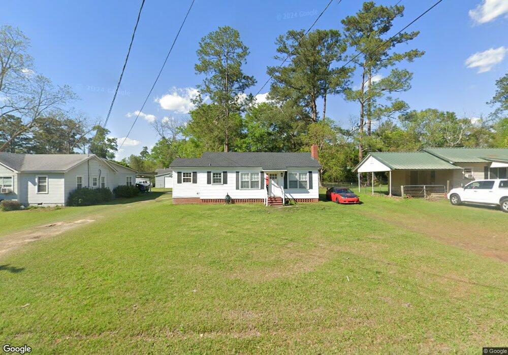
432 Hollis St SW Pelham, GA 31779
Estimated Value: $68,000 - $78,136
--
Bed
1
Bath
912
Sq Ft
$80/Sq Ft
Est. Value
About This Home
This home is located at 432 Hollis St SW, Pelham, GA 31779 and is currently estimated at $72,534, approximately $79 per square foot. 432 Hollis St SW is a home located in Mitchell County with nearby schools including Pelham Elementary School, Pelham City Middle School, and Pelham High School.
Ownership History
Date
Name
Owned For
Owner Type
Purchase Details
Closed on
Sep 15, 2023
Sold by
Carroll Rosa B
Bought by
Brooks Benjamin and Rode Kristine
Current Estimated Value
Home Financials for this Owner
Home Financials are based on the most recent Mortgage that was taken out on this home.
Original Mortgage
$78,551
Outstanding Balance
$76,925
Interest Rate
7.09%
Mortgage Type
New Conventional
Estimated Equity
-$4,391
Purchase Details
Closed on
Nov 1, 2022
Sold by
Carroll Rudolph
Bought by
Carroll Rosa B
Create a Home Valuation Report for This Property
The Home Valuation Report is an in-depth analysis detailing your home's value as well as a comparison with similar homes in the area
Home Values in the Area
Average Home Value in this Area
Purchase History
| Date | Buyer | Sale Price | Title Company |
|---|---|---|---|
| Brooks Benjamin | $80,000 | -- | |
| Carroll Rosa B | $30,939 | -- |
Source: Public Records
Mortgage History
| Date | Status | Borrower | Loan Amount |
|---|---|---|---|
| Open | Brooks Benjamin | $78,551 |
Source: Public Records
Tax History Compared to Growth
Tax History
| Year | Tax Paid | Tax Assessment Tax Assessment Total Assessment is a certain percentage of the fair market value that is determined by local assessors to be the total taxable value of land and additions on the property. | Land | Improvement |
|---|---|---|---|---|
| 2024 | $772 | $17,696 | $2,160 | $15,536 |
| 2023 | $785 | $17,696 | $2,160 | $15,536 |
| 2022 | $618 | $13,936 | $2,160 | $11,776 |
| 2021 | $549 | $12,376 | $2,160 | $10,216 |
| 2020 | $527 | $12,376 | $2,160 | $10,216 |
| 2019 | $530 | $12,176 | $2,160 | $10,016 |
| 2018 | $551 | $12,176 | $2,160 | $10,016 |
| 2017 | $215 | $10,907 | $2,160 | $8,747 |
| 2016 | $223 | $10,907 | $2,160 | $8,747 |
| 2015 | $223 | $10,907 | $2,160 | $8,747 |
| 2014 | $223 | $10,907 | $2,160 | $8,747 |
| 2013 | $223 | $10,907 | $2,160 | $8,747 |
Source: Public Records
Map
Nearby Homes
- 410 Hollis St SW
- 425 Hollis St SW
- 389 Stewart St SW
- 443 Stewart St SW
- 277 Saunders St SW
- 0 Old Ga Highway 3
- 5854 Mount Olive Rd
- 209 McDonald St SW
- 212 Hand Ave W
- 354 Bennett St NW
- 135 Baggs Ave SE
- 3** Youngs Mill Rd
- 210 Castleberry St NW
- 233 Cannon St NW
- 183 Baggs Ave SE
- 199 Carroll St NE
- 375 Baggs Ave SE
- 323 Curry St NE
- 335 Curry St NE
- 438 Dogwood Dr NE
- 440 Hollis St SW
- 426 Hollis St SW
- 416 Hollis St SW
- 448 Hollis St SW
- 482 Sapp Ave SW
- 474 Sapp Ave SW
- 492 Sapp Ave SW
- 462 Sapp Ave SW
- 559 Burum St SW
- 549 Burum St SW
- 421 Hollis St SW
- 539 Burum St SW
- 450 Sapp Ave SW
- 529 Burum St SW
- 371 Stewart St SW
- 401 Stewart St SW
- 362 Legion Dr SW
- 347 Residence St SW
- 481 Sapp Ave SW
- 491 Sapp Ave SW