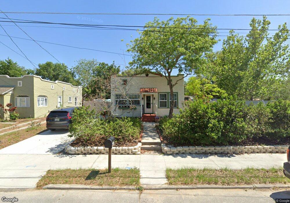
432 Palm Ave Eustis, FL 32726
Estimated Value: $182,330 - $215,000
3
Beds
1
Bath
1,040
Sq Ft
$192/Sq Ft
Est. Value
About This Home
This home is located at 432 Palm Ave, Eustis, FL 32726 and is currently estimated at $199,833, approximately $192 per square foot. 432 Palm Ave is a home located in Lake County with nearby schools including Eustis Heights Elementary School, Eustis Middle School, and Eustis High School.
Ownership History
Date
Name
Owned For
Owner Type
Purchase Details
Closed on
Oct 17, 2002
Sold by
Vick Angela Marie
Bought by
Izzo Kathleen S
Current Estimated Value
Home Financials for this Owner
Home Financials are based on the most recent Mortgage that was taken out on this home.
Original Mortgage
$76,000
Outstanding Balance
$31,376
Interest Rate
6.21%
Estimated Equity
$168,457
Purchase Details
Closed on
Nov 9, 1998
Sold by
Anclam Kathleen M
Bought by
Vick Angela Marie
Purchase Details
Closed on
Mar 27, 1998
Sold by
Roberts Adelaide M and Mccormick Kelly B
Bought by
Anclam Kathleen M
Home Financials for this Owner
Home Financials are based on the most recent Mortgage that was taken out on this home.
Original Mortgage
$33,945
Interest Rate
7.01%
Create a Home Valuation Report for This Property
The Home Valuation Report is an in-depth analysis detailing your home's value as well as a comparison with similar homes in the area
Home Values in the Area
Average Home Value in this Area
Purchase History
| Date | Buyer | Sale Price | Title Company |
|---|---|---|---|
| Izzo Kathleen S | $95,000 | -- | |
| Vick Angela Marie | $62,000 | -- | |
| Anclam Kathleen M | $42,000 | -- |
Source: Public Records
Mortgage History
| Date | Status | Borrower | Loan Amount |
|---|---|---|---|
| Open | Izzo Kathleen S | $76,000 | |
| Previous Owner | Anclam Kathleen M | $33,945 |
Source: Public Records
Tax History
| Year | Tax Paid | Tax Assessment Tax Assessment Total Assessment is a certain percentage of the fair market value that is determined by local assessors to be the total taxable value of land and additions on the property. | Land | Improvement |
|---|---|---|---|---|
| 2026 | $652 | $78,410 | -- | -- |
| 2025 | $636 | $76,280 | -- | -- |
| 2024 | $636 | $76,280 | -- | -- |
| 2023 | $636 | $71,910 | $0 | $0 |
| 2022 | $635 | $69,820 | $0 | $0 |
| 2021 | $625 | $67,795 | $0 | $0 |
| 2020 | $647 | $66,859 | $0 | $0 |
| 2019 | $647 | $65,356 | $0 | $0 |
| 2018 | $624 | $64,138 | $0 | $0 |
| 2017 | $621 | $62,819 | $0 | $0 |
| 2016 | $623 | $61,527 | $0 | $0 |
| 2015 | $636 | $61,100 | $0 | $0 |
| 2014 | $637 | $60,616 | $0 | $0 |
Source: Public Records
Map
Nearby Homes
- 1122 Virginia Ct
- 0 S Mary St
- 312 Osceola Ave
- 203 E Lakeview Ave
- 1033 S Grove St
- 1300 Saint Andrews Blvd
- 206 Osceola Ave
- 809 Poinsettia Dr
- 860 S Grove St
- 301 E Atwater Ave
- 822 Poinsettia Dr
- 436 E Atwater Ave
- 1004 Lantana Dr
- 1814 Sellen Dr
- 1007 Lantana Dr
- 1070 Jasmine St
- 510 E Key Ave
- 1039 Lake Gracie Dr
- 422 S Center St
- 1215 Morin St
Your Personal Tour Guide
Ask me questions while you tour the home.