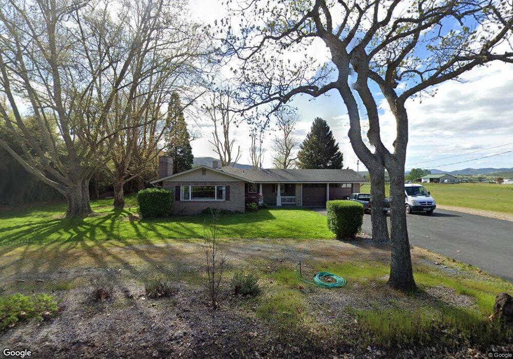
4333 Grant Rd Central Point, OR 97502
Estimated Value: $532,000 - $701,000
4
Beds
3
Baths
1,818
Sq Ft
$334/Sq Ft
Est. Value
About This Home
This home is located at 4333 Grant Rd, Central Point, OR 97502 and is currently estimated at $607,764, approximately $334 per square foot. 4333 Grant Rd is a home located in Jackson County with nearby schools including Richardson Elementary School, Scenic Middle School, and Crater High School.
Ownership History
Date
Name
Owned For
Owner Type
Purchase Details
Closed on
Nov 23, 1999
Sold by
Green Darlene R
Bought by
Galedrige Alan Keith and Galedrige Terri Lynn
Current Estimated Value
Home Financials for this Owner
Home Financials are based on the most recent Mortgage that was taken out on this home.
Original Mortgage
$175,000
Outstanding Balance
$51,036
Interest Rate
7.84%
Estimated Equity
$556,728
Create a Home Valuation Report for This Property
The Home Valuation Report is an in-depth analysis detailing your home's value as well as a comparison with similar homes in the area
Purchase History
| Date | Buyer | Sale Price | Title Company |
|---|---|---|---|
| Galedrige Alan Keith | $195,000 | Amerititle |
Source: Public Records
Mortgage History
| Date | Status | Borrower | Loan Amount |
|---|---|---|---|
| Open | Galedrige Alan Keith | $175,000 |
Source: Public Records
Tax History
| Year | Tax Paid | Tax Assessment Tax Assessment Total Assessment is a certain percentage of the fair market value that is determined by local assessors to be the total taxable value of land and additions on the property. | Land | Improvement |
|---|---|---|---|---|
| 2026 | $4,192 | $343,380 | -- | -- |
| 2025 | $4,096 | $333,380 | $112,990 | $220,390 |
| 2024 | $4,096 | $323,670 | $116,390 | $207,280 |
| 2023 | $3,960 | $314,250 | $113,010 | $201,240 |
| 2022 | $3,875 | $314,250 | $113,010 | $201,240 |
| 2021 | $3,765 | $305,100 | $109,720 | $195,380 |
| 2020 | $3,656 | $296,220 | $106,530 | $189,690 |
| 2019 | $3,571 | $279,230 | $100,420 | $178,810 |
| 2018 | $3,461 | $271,100 | $97,500 | $173,600 |
| 2017 | $3,378 | $271,100 | $97,500 | $173,600 |
| 2016 | $3,280 | $255,550 | $91,900 | $163,650 |
| 2015 | $2,674 | $218,510 | $91,900 | $126,610 |
| 2014 | $2,610 | $205,980 | $86,630 | $119,350 |
Source: Public Records
Map
Nearby Homes
- 1134 Steamboat Dr
- 1407 Rustler Peak St
- 545 Bridge Creek Dr
- 650 Golden Peak Dr
- 0 Boulder Ridge St
- 407 Silver Creek Dr
- 626 Griffin Oaks Dr
- 404 Silver Creek Dr
- 356 Marian Ave Unit 40
- 4626 N Pacific Hwy
- 420 Mayberry Ln
- 884 Mendolia Way
- 1860 Cottonwood Dr
- 1855 Nancy Ave
- 166 Nadine Ln
- 55 Crater Ln
- 342 Hazel St
- 349 W Pine St
- 5030 Del Mar Dr
- 209 Corcoran Ln
- 4305 Grant Rd
- 925 Buck Point St
- 927 Buck Point St
- 923 Buck Point St
- 929 Buck Point St
- 4270 Grant Rd
- 921 Buck Point St
- 819 Buck Point St
- 817 Buck Point St
- 926 Buck Point St
- 928 Buck Point St
- 4419 Grant Rd
- 924 Buck Point St
- 930 Buck Point St
- 815 Buck Point St
- 920 Buck Point St
- 4215 Grant Rd
- 813 Buck Point St
- 1118 Twin Creeks Crossing
- 1125 Twin Creeks Crossing
Your Personal Tour Guide
Ask me questions while you tour the home.