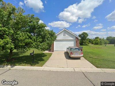
4336 Bridgeport Ct Unit 79 Inkster, MI 48141
Estimated Value: $143,000 - $264,000
--
Bed
--
Bath
1,520
Sq Ft
$132/Sq Ft
Est. Value
About This Home
This home is located at 4336 Bridgeport Ct Unit 79, Inkster, MI 48141 and is currently estimated at $200,125, approximately $131 per square foot. 4336 Bridgeport Ct Unit 79 is a home located in Wayne County with nearby schools including Taylor Parks Elementary School, Hoover Middle School, and Taylor High School.
Ownership History
Date
Name
Owned For
Owner Type
Purchase Details
Closed on
Sep 27, 2011
Sold by
Rockefeller Mary E and Mary E Rockefeller Trust
Bought by
Rockefeller Wayne and Rockefeller William
Current Estimated Value
Purchase Details
Closed on
Apr 1, 2010
Sold by
Rockefeller Mary E and Mcelveen Leroy
Bought by
Mary E Rockefeller Trust
Purchase Details
Closed on
Jan 26, 2008
Sold by
Mcelveen Leroy
Bought by
Mcelven Leroy
Purchase Details
Closed on
Aug 16, 2007
Sold by
Hawker Development Llc
Bought by
Mcelveen Leroy
Create a Home Valuation Report for This Property
The Home Valuation Report is an in-depth analysis detailing your home's value as well as a comparison with similar homes in the area
Home Values in the Area
Average Home Value in this Area
Purchase History
| Date | Buyer | Sale Price | Title Company |
|---|---|---|---|
| Rockefeller Wayne | -- | None Available | |
| Mary E Rockefeller Trust | -- | None Available | |
| Mcelven Leroy | -- | None Available | |
| Mcelveen Leroy | $25,000 | Lamont Title Corporation |
Source: Public Records
Tax History Compared to Growth
Tax History
| Year | Tax Paid | Tax Assessment Tax Assessment Total Assessment is a certain percentage of the fair market value that is determined by local assessors to be the total taxable value of land and additions on the property. | Land | Improvement |
|---|---|---|---|---|
| 2024 | $1,534 | $92,100 | $0 | $0 |
| 2023 | $1,717 | $68,000 | $0 | $0 |
| 2022 | $2,278 | $56,500 | $0 | $0 |
| 2021 | $2,392 | $51,500 | $0 | $0 |
| 2020 | $2,334 | $46,400 | $0 | $0 |
| 2019 | $2,325 | $42,700 | $0 | $0 |
| 2018 | $1,602 | $32,700 | $0 | $0 |
| 2017 | $1,160 | $28,800 | $0 | $0 |
| 2016 | $2,263 | $26,800 | $0 | $0 |
| 2015 | $3,210 | $32,100 | $0 | $0 |
| 2013 | $4,500 | $45,000 | $0 | $0 |
| 2012 | $2,939 | $51,000 | $14,400 | $36,600 |
Source: Public Records
Map
Nearby Homes
- 29207 York St
- 4149 Harriet St
- 4543 Harriet St
- 29025 Eton St
- 29056 Powers St
- 4123 Burton St
- 28919 Powers St
- 4941 Julius Blvd
- 4770 Matthew St
- 3617 Hickory St
- 27842 Carlysle St
- 3512 Hickory St
- 4054 Moore St
- 4013 Moore St
- 4130 Allen St
- 30102 Matthew St
- 29685 Lacy Dr Unit 76
- 30112 Matthew St
- 3160 Ash St
- 30101 Matthew St
- 4336 Bridgeport Ct Unit 79
- 4332 Bridgeport Ct
- 4340 Bridgeport Ct
- 4176 Crystal Ct
- 4172 Crystal Ct
- 4344 Bridgeport Ct
- 4323 Bridgeport Ct
- 4327 Bridgeport Ct
- 4328 Bridgeport Ct
- 4182 Crystal Ct
- 4168 Crystal Ct
- 4331 Bridgeport Ct
- 4186 Crystal Ct
- 4324 Bridgeport Ct
- 4348 Bridgeport Ct Unit 76
- 4335 Bridgeport Ct
- 4320 Bridgeport Ct Unit 83
- 4164 Crystal Ct
- 4173 Crystal Ct
- 4175 Crystal Ct