Estimated Value: $228,000 - $296,000
3
Beds
1
Bath
1,595
Sq Ft
$165/Sq Ft
Est. Value
About This Home
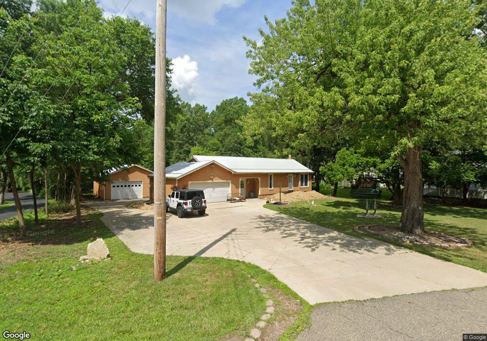
This home is located at 4344 Stow Rd, Stow, OH 44224 and is currently estimated at $263,429, approximately $165 per square foot. 4344 Stow Rd is a home located in Summit County with nearby schools including Stow-Munroe Falls High School, Primrose School of Hudson, and Holy Family Elementary School.
Ownership History
Date
Name
Owned For
Owner Type
Purchase Details
Closed on
Oct 21, 2025
Sold by
Delapaz Jaime
Bought by
Fabela-Carmona Antonio and Delcarmona Maria Del
Current Estimated Value
Purchase Details
Closed on
Aug 17, 2000
Sold by
Campfield Edwin M and Campfield Donna J
Bought by
Delapaz Jaime
Home Financials for this Owner
Home Financials are based on the most recent Mortgage that was taken out on this home.
Original Mortgage
$108,000
Outstanding Balance
$48,170
Interest Rate
11.79%
Estimated Equity
$215,259
Create a Home Valuation Report for This Property
The Home Valuation Report is an in-depth analysis detailing your home's value as well as a comparison with similar homes in the area
Home Values in the Area
Average Home Value in this Area
Purchase History
| Date | Buyer | Sale Price | Title Company |
|---|---|---|---|
| Fabela-Carmona Antonio | $295,000 | None Listed On Document | |
| Delapaz Jaime | $120,000 | Americas Choice Title Agency |
Source: Public Records
Mortgage History
| Date | Status | Borrower | Loan Amount |
|---|---|---|---|
| Open | Delapaz Jaime | $108,000 |
Source: Public Records
Tax History
| Year | Tax Paid | Tax Assessment Tax Assessment Total Assessment is a certain percentage of the fair market value that is determined by local assessors to be the total taxable value of land and additions on the property. | Land | Improvement |
|---|---|---|---|---|
| 2025 | $4,234 | $70,952 | $14,728 | $56,224 |
| 2024 | $4,234 | $70,952 | $14,728 | $56,224 |
| 2023 | $4,234 | $70,952 | $14,728 | $56,224 |
| 2022 | $3,853 | $56,820 | $11,596 | $45,224 |
| 2021 | $3,374 | $56,820 | $11,596 | $45,224 |
| 2020 | $3,418 | $56,820 | $11,600 | $45,220 |
| 2019 | $3,360 | $52,170 | $18,450 | $33,720 |
| 2018 | $3,308 | $52,170 | $18,450 | $33,720 |
| 2017 | $3,027 | $52,170 | $18,450 | $33,720 |
| 2016 | $3,114 | $48,990 | $18,450 | $30,540 |
| 2015 | $3,027 | $48,990 | $18,450 | $30,540 |
| 2014 | $3,030 | $48,990 | $18,450 | $30,540 |
| 2013 | $3,168 | $51,620 | $18,450 | $33,170 |
Source: Public Records
Map
Nearby Homes
- 4424 Timberdale Dr Unit 4428
- 2344 Echo Valley Dr
- 4287 Osage St
- 4706-4710 Maple Spur Dr
- 4138 Genevieve Blvd
- 4728 Fishcreek Rd
- 2055-2059 Bryn Mawr Dr
- 1953 Arndale Rd
- 4534 Foresthill Rd
- 4205 Osage St
- 1969 Conwill Rd Unit 1973
- 1921-1929 Ritchie Rd
- 4556 Fishcreek Rd
- 4544 Fishcreek Rd
- 4623 Cox Dr
- 4625 Cox Dr Unit B
- 4003 Kenneth Rd
- 4040 Burton Dr
- 2221 Crockett Cir
- 3943 Darrow Rd
Your Personal Tour Guide
Ask me questions while you tour the home.