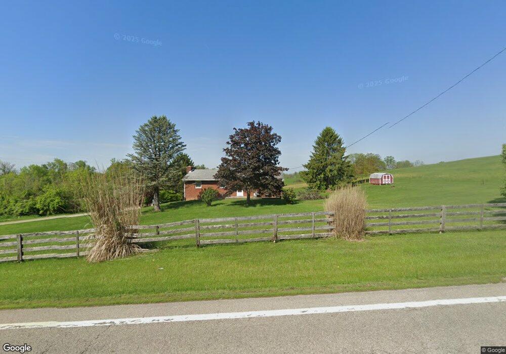
4345 Friendship Dr New Concord, OH 43762
Estimated Value: $261,025 - $328,000
3
Beds
2
Baths
1,269
Sq Ft
$229/Sq Ft
Est. Value
About This Home
This home is located at 4345 Friendship Dr, New Concord, OH 43762 and is currently estimated at $290,006, approximately $228 per square foot. 4345 Friendship Dr is a home located in Muskingum County with nearby schools including New Concord Elementary School, East Muskingum Middle School, and Larry Miller Intermediate Elementary School.
Ownership History
Date
Name
Owned For
Owner Type
Purchase Details
Closed on
Aug 17, 1999
Sold by
Geyer Sandra M
Bought by
Yarger Michael J
Current Estimated Value
Home Financials for this Owner
Home Financials are based on the most recent Mortgage that was taken out on this home.
Original Mortgage
$66,900
Outstanding Balance
$19,405
Interest Rate
7.77%
Mortgage Type
New Conventional
Estimated Equity
$270,601
Create a Home Valuation Report for This Property
The Home Valuation Report is an in-depth analysis detailing your home's value as well as a comparison with similar homes in the area
Home Values in the Area
Average Home Value in this Area
Purchase History
| Date | Buyer | Sale Price | Title Company |
|---|---|---|---|
| Yarger Michael J | $85,900 | -- |
Source: Public Records
Mortgage History
| Date | Status | Borrower | Loan Amount |
|---|---|---|---|
| Open | Yarger Michael J | $66,900 |
Source: Public Records
Tax History Compared to Growth
Tax History
| Year | Tax Paid | Tax Assessment Tax Assessment Total Assessment is a certain percentage of the fair market value that is determined by local assessors to be the total taxable value of land and additions on the property. | Land | Improvement |
|---|---|---|---|---|
| 2024 | $2,185 | $66,815 | $4,900 | $61,915 |
| 2023 | $1,790 | $51,205 | $4,235 | $46,970 |
| 2022 | $1,753 | $51,205 | $4,235 | $46,970 |
| 2021 | $1,731 | $51,205 | $4,235 | $46,970 |
| 2020 | $1,551 | $44,520 | $3,675 | $40,845 |
| 2019 | $1,543 | $44,520 | $3,675 | $40,845 |
| 2018 | $1,577 | $44,520 | $3,675 | $40,845 |
| 2017 | $1,231 | $33,670 | $3,675 | $29,995 |
| 2016 | $1,233 | $33,680 | $3,680 | $30,000 |
| 2015 | $1,264 | $33,680 | $3,680 | $30,000 |
| 2013 | $1,356 | $33,680 | $3,680 | $30,000 |
Source: Public Records
Map
Nearby Homes
- 0 Norfield Unit 5124761
- 5580 Friendship Dr
- 12985 John Glenn School Rd
- 2895 N Moose Eye Rd
- 1165 Friendship Dr
- 930 Friendship Dr
- 760 Friendship Dr
- 53 Paden Rd
- 6825 Barr Rd
- 154 Montgomery Blvd
- 112 Thompson Ave
- 8 E Main St
- 67 E Main St
- 1420 Glenn Hwy
- 225 Homestead Dr
- 0 Maple Ln
- 9380 Pidcock Rd
- 60936 Patch Rd
- 10545 Main St
- 64895 Lovers Lane Rd
- 4380 Friendship Dr
- 4250 Friendship Dr
- 4165 Friendship Dr
- 4555 Friendship Dr
- 4065 Friendship Dr
- 4600 Friendship Dr
- 4575 Friendship Dr
- 4095 Friendship Dr Unit 1
- 4095 Friendship Dr
- 4025 Friendship Dr
- 4620 Friendship Dr
- 4610 Friendship Dr
- 3885 Friendship Dr
- 4780 Friendship Dr
- 11965 Norfield Rd
- 4860 Friendship Dr
- 11955 Norfield Rd
- 11885 Norfield Rd
- 4995 Friendship
- 0 Norfield Unit 309668