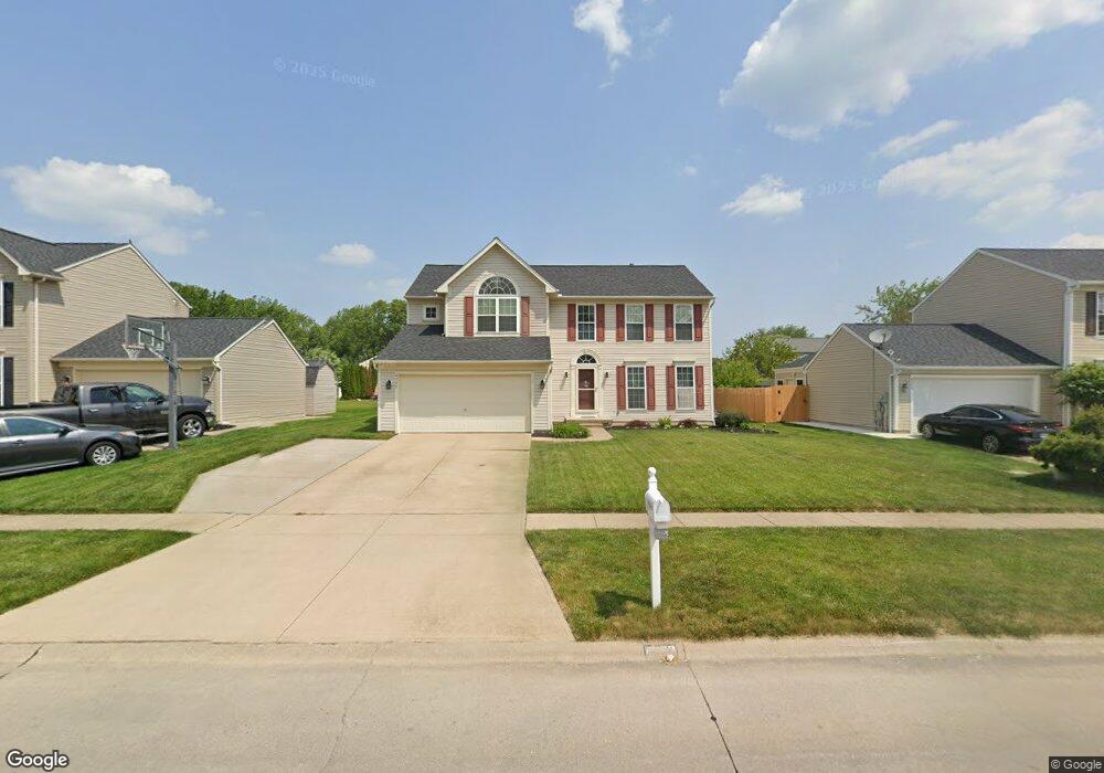
4346 Jenee Dr Lorain, OH 44053
Estimated Value: $308,625 - $382,000
4
Beds
3
Baths
2,498
Sq Ft
$139/Sq Ft
Est. Value
About This Home
This home is located at 4346 Jenee Dr, Lorain, OH 44053 and is currently estimated at $347,406, approximately $139 per square foot. 4346 Jenee Dr is a home located in Lorain County with nearby schools including Powers Elementary School, Walter G. Nord Middle School, and Amherst Junior High School.
Ownership History
Date
Name
Owned For
Owner Type
Purchase Details
Closed on
Aug 17, 2016
Sold by
Bank Of America
Bought by
Hud
Current Estimated Value
Purchase Details
Closed on
Mar 19, 2002
Sold by
Nvr Inc
Bought by
Molnar Nicholas J and Molnar Deborah E
Home Financials for this Owner
Home Financials are based on the most recent Mortgage that was taken out on this home.
Original Mortgage
$204,859
Interest Rate
6.82%
Mortgage Type
FHA
Create a Home Valuation Report for This Property
The Home Valuation Report is an in-depth analysis detailing your home's value as well as a comparison with similar homes in the area
Home Values in the Area
Average Home Value in this Area
Purchase History
| Date | Buyer | Sale Price | Title Company |
|---|---|---|---|
| Hud | -- | -- | |
| Molnar Nicholas J | $208,100 | Nvr Title Agency Llc |
Source: Public Records
Mortgage History
| Date | Status | Borrower | Loan Amount |
|---|---|---|---|
| Previous Owner | Molnar Nicholas J | $204,859 |
Source: Public Records
Tax History Compared to Growth
Tax History
| Year | Tax Paid | Tax Assessment Tax Assessment Total Assessment is a certain percentage of the fair market value that is determined by local assessors to be the total taxable value of land and additions on the property. | Land | Improvement |
|---|---|---|---|---|
| 2024 | $800 | $19,250 | $19,250 | -- |
| 2023 | $662 | $13,444 | $13,444 | $0 |
| 2022 | $636 | $13,444 | $13,444 | $0 |
| 2021 | $637 | $13,444 | $13,444 | $0 |
| 2020 | $634 | $11,840 | $11,840 | $0 |
| 2019 | $621 | $11,840 | $11,840 | $0 |
| 2018 | $3,494 | $67,100 | $11,840 | $55,260 |
| 2017 | $3,450 | $61,950 | $13,580 | $48,370 |
| 2016 | $3,425 | $61,950 | $13,580 | $48,370 |
| 2015 | $3,310 | $61,950 | $13,580 | $48,370 |
| 2014 | $3,423 | $63,870 | $14,000 | $49,870 |
| 2013 | $3,432 | $63,870 | $14,000 | $49,870 |
Source: Public Records
Map
Nearby Homes
- 4513 Vineyard Dr
- 3982 Courtyard Dr
- 3794 Freedom Place
- 3788 Freedom Place
- 3784 Freedom Place
- 3774 Freedom Place Unit A
- 3772 Freedom Place Unit B
- 3770 Freedom Place Unit C
- 1301 N Main St
- 110 Habant Dr
- 3741 Freedom Place Unit 5-A
- 251 Habant Dr
- 4887 Meadow Lark Dr
- 1280 Meadowview Ln
- 3633 Reserve Trail
- 3768 Martins Run Dr
- 5537 Beavercrest Dr Unit 102
- 3472 Magnolia Dr
- 5519 Manhattan Dr
- 4201 Meadow Lark Dr
- 4356 Jenee Dr
- 4336 Jenee Dr
- 4309 Rosemont Ct
- 4366 Jenee Dr
- 4317 Rosemont Ct
- 4326 Jenee Dr
- 4305 Rosemont Ct
- 4367 Jenee Dr
- 4377 Jenee Dr
- 4357 Jenee Dr
- 4316 Jenee Dr
- 4387 Jenee Dr
- 4325 Rosemont Ct
- 4306 Jenee Dr
- 4347 Jenee Dr
- 4651 Camden Blvd
- 4376 Jenee Dr
- 4403 Yorktown Ct
- 4337 Jenee Dr
- 4402 Yorktown Ct