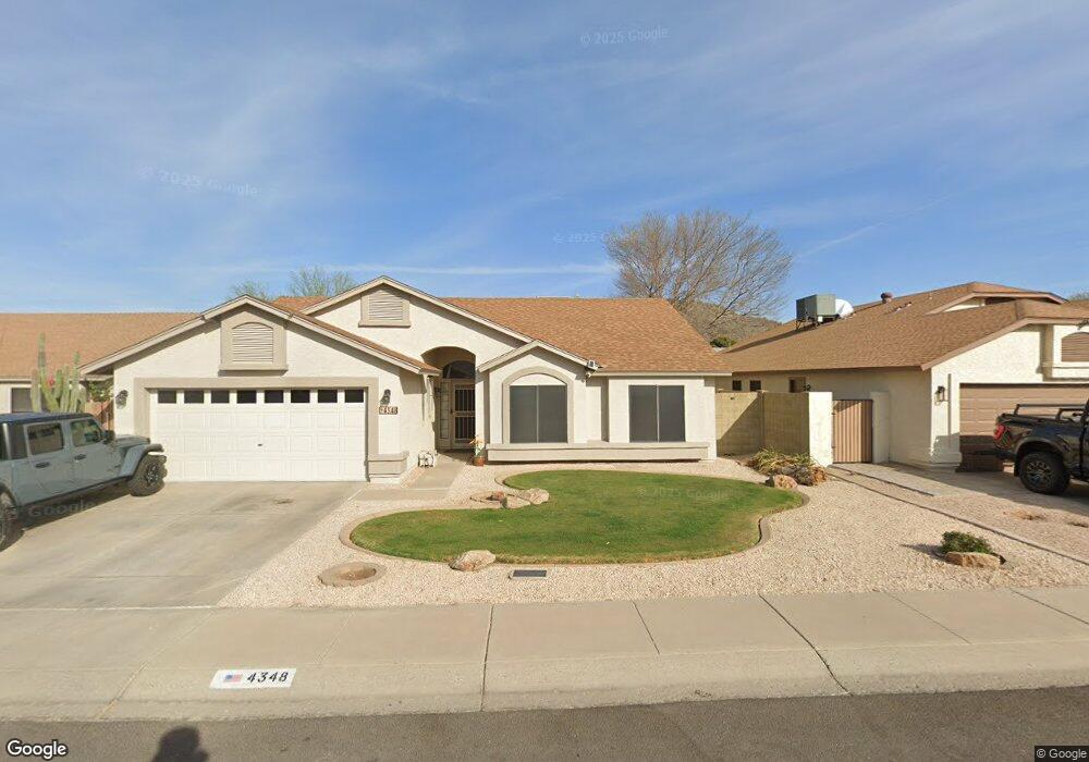
4348 W Behrend Dr Glendale, AZ 85308
Deer Valley NeighborhoodEstimated Value: $346,836 - $465,000
Studio
2
Baths
1,638
Sq Ft
$259/Sq Ft
Est. Value
About This Home
This home is located at 4348 W Behrend Dr, Glendale, AZ 85308 and is currently estimated at $423,709, approximately $258 per square foot. 4348 W Behrend Dr is a home located in Maricopa County with nearby schools including Mountain Shadows Elementary School, Desert Sky Middle School, and Deer Valley High School.
Ownership History
Date
Name
Owned For
Owner Type
Purchase Details
Closed on
Jun 4, 2025
Sold by
Taylor Craig E and Taylor Deeanna J
Bought by
Craig And Deeanna Taylor Family Trust and Taylor
Current Estimated Value
Purchase Details
Closed on
Apr 28, 2014
Sold by
Taylor Craig E and Taylor Deeanna J
Bought by
Taylor Craig E and Taylor Deeanna J
Home Financials for this Owner
Home Financials are based on the most recent Mortgage that was taken out on this home.
Original Mortgage
$78,160
Interest Rate
4.35%
Mortgage Type
New Conventional
Create a Home Valuation Report for This Property
The Home Valuation Report is an in-depth analysis detailing your home's value as well as a comparison with similar homes in the area
Home Values in the Area
Average Home Value in this Area
Purchase History
| Date | Buyer | Sale Price | Title Company |
|---|---|---|---|
| Craig And Deeanna Taylor Family Trust | -- | None Listed On Document | |
| Taylor Craig E | -- | First American Equity Loan S |
Source: Public Records
Mortgage History
| Date | Status | Borrower | Loan Amount |
|---|---|---|---|
| Previous Owner | Taylor Craig E | $78,160 |
Source: Public Records
Tax History
| Year | Tax Paid | Tax Assessment Tax Assessment Total Assessment is a certain percentage of the fair market value that is determined by local assessors to be the total taxable value of land and additions on the property. | Land | Improvement |
|---|---|---|---|---|
| 2025 | $1,548 | $17,805 | -- | -- |
| 2024 | $1,507 | $16,957 | -- | -- |
| 2023 | $1,507 | $29,260 | $5,850 | $23,410 |
| 2022 | $1,451 | $22,650 | $4,530 | $18,120 |
| 2021 | $1,515 | $20,650 | $4,130 | $16,520 |
| 2020 | $1,487 | $19,360 | $3,870 | $15,490 |
| 2019 | $1,442 | $18,410 | $3,680 | $14,730 |
| 2018 | $1,392 | $16,980 | $3,390 | $13,590 |
| 2017 | $1,344 | $15,630 | $3,120 | $12,510 |
| 2016 | $1,268 | $13,870 | $2,770 | $11,100 |
| 2015 | $1,132 | $13,480 | $2,690 | $10,790 |
Source: Public Records
Map
Nearby Homes
- 19808 N 44th Dr
- 19842 N 44th Dr
- 4436 W Escuda Dr
- 4413 W Oraibi Dr
- 4209 W Wahalla Ln
- 4324 W Yorkshire Dr
- 4308 W Yorkshire Dr
- 19405 N 45th Dr
- 19837 N 46th Dr
- 4426 W Wescott Dr
- 4439 W Wescott Dr
- 4760 W Wahalla Ln
- 4133 W Topeka Dr
- 18815 N 43rd Dr
- 18846 N 45th Ave
- 4779 W Piute Ave
- 19637 N 49th Ave
- 20644 N 41st Ave
- 4608 W Morrow Dr
- 4927 W Escuda Dr
- 4352 W Behrend Dr
- 4342 W Behrend Dr
- 4355 W Marco Polo Rd
- 4351 W Marco Polo Rd
- 4338 W Behrend Dr
- 4358 W Behrend Dr
- 19818 N 43rd Ln
- 4359 W Marco Polo Rd
- 4347 W Marco Polo Rd
- 4334 W Behrend Dr
- 19805 N 44th Ave
- 4341 W Marco Polo Rd
- 4363 W Marco Polo Rd
- 19812 N 43rd Ln
- 19817 N 43rd Ln
- 4328 W Behrend Dr
- 4368 W Behrend Dr
- 4335 W Marco Polo Rd
- 4367 W Marco Polo Rd
- 19813 N 43rd Ln
Your Personal Tour Guide
Ask me questions while you tour the home.