
Seller's Agent in 2025
Maria Chebrova
Smith Realty Group
(541) 579-6150
3 in this area
13 Total Sales

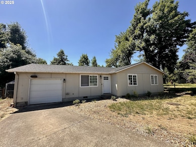


Great starter home or Investment opportunity!!! Settled in the cul-de-sac, has newer roof, updated kitchen with stainless steel appliances. Laminate floors throughout the house. Private back yard! Needs some TLC. Call or text for more information!
Last Agent to Sell the Property
Smith Realty Group Brokerage Email: Sherri@smithrealtygroup.net License #200706156 Listed on: 07/10/2025
| Date | Type | Sale Price | Title Company |
|---|---|---|---|
| Warranty Deed | $305,000 | Evergreen Land Title Company | |
| Warranty Deed | $116,000 | Western Title & Escrow Co | |
| Warranty Deed | $99,750 | Western Title & Escrow Compa |
| Date | Status | Loan Amount | Loan Type |
|---|---|---|---|
| Open | $295,850 | New Conventional | |
| Previous Owner | $80,800 | Purchase Money Mortgage | |
| Previous Owner | $69,825 | No Value Available |
| Date | Event | Price | List to Sale | Price per Sq Ft |
|---|---|---|---|---|
| 08/29/2025 08/29/25 | Sold | $305,000 | +1.7% | $303 / Sq Ft |
| 08/03/2025 08/03/25 | Pending | -- | -- | -- |
| 08/01/2025 08/01/25 | Price Changed | $299,900 | -6.0% | $298 / Sq Ft |
| 07/10/2025 07/10/25 | For Sale | $319,000 | -- | $316 / Sq Ft |
| Year | Tax Paid | Tax Assessment Tax Assessment Total Assessment is a certain percentage of the fair market value that is determined by local assessors to be the total taxable value of land and additions on the property. | Land | Improvement |
|---|---|---|---|---|
| 2025 | $2,435 | $148,375 | -- | -- |
| 2024 | $1,822 | $144,054 | -- | -- |
| 2023 | $1,822 | $139,859 | $0 | $0 |
| 2022 | $1,962 | $135,786 | $0 | $0 |
| 2021 | $1,895 | $131,832 | $0 | $0 |
| 2020 | $1,869 | $127,993 | $0 | $0 |
| 2019 | $1,828 | $124,266 | $0 | $0 |
| 2018 | $1,802 | $117,133 | $0 | $0 |
| 2017 | $1,748 | $117,133 | $0 | $0 |
| 2016 | $1,790 | $113,721 | $0 | $0 |
| 2015 | $1,726 | $110,409 | $0 | $0 |
| 2014 | $1,711 | $107,193 | $0 | $0 |
Seller's Agent in 2025
Maria Chebrova
Smith Realty Group
(541) 579-6150
3 in this area
13 Total Sales
Buyer's Agent in 2025
James Sisneroz
Harcourts West Real Estate
(541) 232-6990
2 in this area
40 Total Sales
Source: Regional Multiple Listing Service (RMLS)
MLS Number: 435153248
APN: 1247632
Disclaimer: Certain information contained herein is derived from information provided by parties other than Homes.com. All information provided is deemed reliable, but is not guaranteed to be accurate and should be independently verified.
![]() The content relating to real estate for sale on this web site comes in part from the IDX program of the RMLS™ of Portland, Oregon. Real estate listings held by brokerage firms other than Ten-X are marked with the RMLS™ logo, and detailed information about these properties includes the names of the listing brokers. Listing content is copyright © 2025 RMLS™, Portland, Oregon. Some properties which appear for sale on this web site may subsequently have sold or may no longer be available. All information provided is deemed reliable but is not guaranteed and should be independently verified.
The content relating to real estate for sale on this web site comes in part from the IDX program of the RMLS™ of Portland, Oregon. Real estate listings held by brokerage firms other than Ten-X are marked with the RMLS™ logo, and detailed information about these properties includes the names of the listing brokers. Listing content is copyright © 2025 RMLS™, Portland, Oregon. Some properties which appear for sale on this web site may subsequently have sold or may no longer be available. All information provided is deemed reliable but is not guaranteed and should be independently verified.