NOT LISTED FOR SALE

435 W Coyote Dr Silverthorne, CO 80498

Estimated Value: $861,000 - $1,275,000

0.22 Acre
$4,969,786 Price per Acre
9,583 Sq Ft Lot

Last Sold August 03, 2018

Last sale price $299,900

Est. 265% increase in value since last sale

Current estimated payment $6,552/month

676 Days on Market

About This Lot

As of August 2018

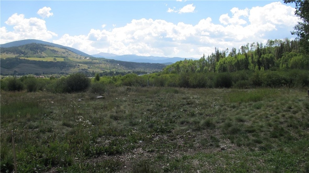
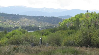
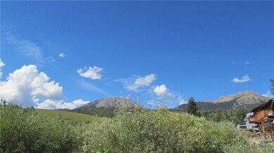
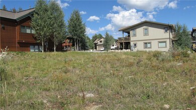
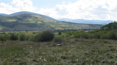
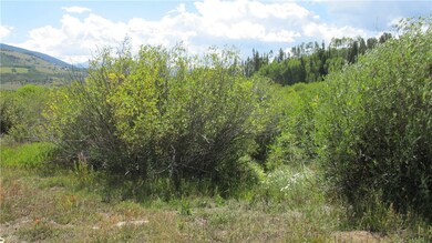
Sunny, flat building site backing to the wetlands with Willow Creek running behind the lot. Views to Keystone ski slopes. 0.22 acres, ready for your custom mountain home in this sought after neighborhood. This lot is best suited for a duplex or single family home but is zoned for a triplex so there are many possibilities. Playground, park, and tennis courts are close by at the entrance to the neighborhood.

Last Agent to Sell the Property

Henry Barr

RE/MAX Properties of the Summit License #EA230071 Listed on: 08/26/2016

RE/MAX Properties of the Summit

Last Buyer's Agent

Todd Rankin

Cornerstone RE Rocky Mountains License #FA100007266

Property Details

Property Type

  • Land

Year Built

  • 2019

Lot Details

  • 9,583 Sq Ft Lot
  • Zoning described as Duplex

HOA Fees

  • $33 Monthly HOA Fees

Property Views

  • River
  • Ski Resort
  • Creek or Stream
  • Mountain
  • Meadow

Utilities

  • Phone Available
  • Satellite Dish
  • Cable TV Available

Community Details

  • Association fees include common area maintenance
  • Willowbrook Meadows Sub Subdivision

Listing and Financial Details

  • Assessor Parcel Number 6506583

Property Details

Property Type

Land

Year Built

2019

Lot Details

0

HOA Fees

$33 per month

Listing Details

  • Property Sub Type: Unimproved Land
  • Prop. Type: Land
  • Lot Size Acres: 0.22
  • Subdivision Name: WILLOWBROOK MEADOWS SUB
  • Directions: From Hwy 9 headed North turn left at Willowbrook Road. Left at S. Chipmunk, right at W. Coyote. Lot is on the left side.
  • Property Sub Type Additional: Unimproved Land
  • Special Features: None
  • Year Built (Public Record): 2019

Interior Features

  • Other Equipment: Satellite Dish

Exterior Features

  • Lot Features: See Remarks
  • View: Meadow, Mountain(s), River, Ski Area, Creek/Stream
  • View: Yes
  • Exclusions: No

Utilities

  • Utilities: Cable Available, Electricity Available, Natural Gas Available, Municipal Utilities, Phone Available, Trash Collection, Water Available, Sewer Available
  • Water Source: Public

Condo/Co-op/Association

  • Association Fee: 396.0
  • Association Fee Frequency: Annually

Fee Information

  • Association Fee Includes: Common Area Maintenance

Lot Info

  • Land Lease: No
  • Lot Size Sq Ft: 9583.2
  • Parcel #: 6506583
  • Zoning Description: Duplex

Tax Info

  • Tax Annual Amount: 5095.0
  • Tax Year: 2018

Ownership History

Date Name Owned For Owner Type

Purchase Details

Closed on
Jan 16, 2020
Sold by
Bluebird Development Llc
Bought by
Mcnally Christopher and Mcnally Michelle Lynn
Total Days on Market
676
Current Estimated Value
$1,093,353

Home Financials for this Owner

Home Financials are based on the most recent Mortgage that was taken out on this home.
Original Mortgage
$657,600
Outstanding Balance
$587,194
Interest Rate
3.6%
Mortgage Type
New Conventional
Estimated Equity
$575,168

Purchase Details

Closed on
Dec 3, 2019
Sold by
Bluebird Development Llc
Bought by
Powers Carolanne

Home Financials for this Owner

Home Financials are based on the most recent Mortgage that was taken out on this home.
Original Mortgage
$657,600
Outstanding Balance
$587,194
Interest Rate
3.6%
Mortgage Type
New Conventional
Estimated Equity
$575,168

Purchase Details

Closed on
Apr 1, 2019
Sold by
Rankin Todd
Bought by
Bluebird Development Llc

Home Financials for this Owner

Home Financials are based on the most recent Mortgage that was taken out on this home.
Original Mortgage
$1,029,262
Interest Rate
4.3%
Mortgage Type
Future Advance Clause Open End Mortgage
Source: Public Records

Range of Values:

Collateral Analytics

Collateral Analytics Collateral Analytics AVMs (Automated Valuation Model) employ a number of statistical approaches combined with neighborhood-specific comparable selection guarantees the most up-to-date and precise valuations.

Not Available

Collateral Analytics does not have data for the current month. Please view the chart for historical values.

ICE

ICE Mortgage Technology ICE Mortgage Technology’s AVM (Automated Valuation Model) is a state-of-the-art online residential property valuation tool that provides a quick and accurate estimate of the value of almost any home in the U.S.

Not Available

ICE Mortgage Technology does not have data for the current month. Please view the chart for historical values.

First American

First American First American Data & Analytics’ next-generation AVM combines unrivaled data assets with a blended ensemble of valuation models to produce highly accurate, reliable valuations you can trust.

Not Available

First American does not have data for the current month. Please view the chart for historical values.

Quantarium

Quantarium Quantarium’s valuation service, repeatedly proven the industry’s most accurate and comprehensive, is supercharged with a self-learning and auto-tuning AI engine that continually becomes smarter and more accurate as it processes daily inputs from the industry’s leading RE data lake.

Not Available

Quantarium does not have data for the current month. Please view the chart for historical values.

Average Value
Not Available
List Price
Sold Price
Create a Home Valuation Report for This Property
The Home Valuation Report is an in-depth analysis detailing your home's value as well as a comparison with similar homes in the area

Home Values in the Area

Source: Public Records

Average Home Value in this Area


Source: Public Records

Purchase History

Date Buyer Sale Price Title Company
Mcnally Christopher $822,000 Land Title Guarantee
Powers Carolanne -- None Available
Bluebird Development Llc -- Land Title Guarantee
Source: Public Records

Mortgage History

Date Status Borrower Loan Amount
Open Powers Carolanne B $320,000
Open Mcnally Christopher $657,600
Closed Powers Carol Anne $650,000
Previous Owner Bluebird Development Llc $1,029,262
Source: Public Records

Property History

Date Event Price Change Sq Ft Price
08/03/2018 08/03/18 Sold $299,900 0.0% --
07/04/2018 07/04/18 Pending -- -- --
08/26/2016 08/26/16 For Sale $299,900 -- --
Source: Summit MLS

Tax History Compared to Growth

Source: Public Records

Tax History

Year Tax Paid Tax Assessment Tax Assessment Total Assessment is a certain percentage of the fair market value that is determined by local assessors to be the total taxable value of land and additions on the property. Land Improvement
2024 $4,855 $93,559 -- --
2023 $4,855 $89,874 $0 $0
2022 $3,658 $64,023 $0 $0
2021 $3,690 $65,866 $0 $0
2020 $2,867 $54,672 $0 $0
Source: Public Records

Agents Affiliated with this Home

  • Section Image
  • Section Image
See All Agents

Map

Source: Summit MLS

MLS Number: S1002429

Summit MLS

APN: 6518627