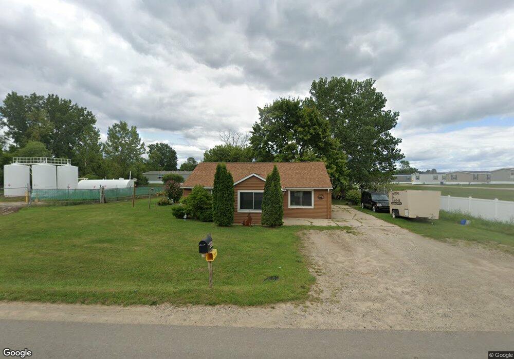
4357 12th St Wayland, MI 49348
Estimated Value: $214,270 - $289,000
--
Bed
1
Bath
1,560
Sq Ft
$163/Sq Ft
Est. Value
About This Home
This home is located at 4357 12th St, Wayland, MI 49348 and is currently estimated at $254,568, approximately $163 per square foot. 4357 12th St is a home located in Allegan County with nearby schools including Wayland High School and Moline Christian School.
Ownership History
Date
Name
Owned For
Owner Type
Purchase Details
Closed on
Aug 1, 2007
Sold by
Baker John L
Bought by
Wolf Michael
Current Estimated Value
Home Financials for this Owner
Home Financials are based on the most recent Mortgage that was taken out on this home.
Original Mortgage
$65,000
Outstanding Balance
$41,218
Interest Rate
6.69%
Mortgage Type
Purchase Money Mortgage
Estimated Equity
$213,350
Purchase Details
Closed on
Aug 9, 1994
Sold by
Baker Fred
Bought by
Baker John L and Baker Lucinda K
Create a Home Valuation Report for This Property
The Home Valuation Report is an in-depth analysis detailing your home's value as well as a comparison with similar homes in the area
Home Values in the Area
Average Home Value in this Area
Purchase History
| Date | Buyer | Sale Price | Title Company |
|---|---|---|---|
| Wolf Michael | $65,000 | Title Pro Agency | |
| Baker John L | $30,000 | -- |
Source: Public Records
Mortgage History
| Date | Status | Borrower | Loan Amount |
|---|---|---|---|
| Open | Wolf Michael | $65,000 |
Source: Public Records
Tax History Compared to Growth
Tax History
| Year | Tax Paid | Tax Assessment Tax Assessment Total Assessment is a certain percentage of the fair market value that is determined by local assessors to be the total taxable value of land and additions on the property. | Land | Improvement |
|---|---|---|---|---|
| 2025 | $1,089 | $77,100 | $14,300 | $62,800 |
| 2024 | $1,014 | $73,500 | $14,300 | $59,200 |
| 2023 | $1,014 | $66,800 | $14,300 | $52,500 |
| 2022 | $1,014 | $63,300 | $12,500 | $50,800 |
| 2021 | $936 | $58,900 | $12,500 | $46,400 |
| 2020 | $918 | $56,100 | $12,500 | $43,600 |
| 2019 | $892 | $48,900 | $12,500 | $36,400 |
| 2018 | $1,609 | $46,500 | $12,500 | $34,000 |
| 2017 | $0 | $44,800 | $12,500 | $32,300 |
| 2016 | $0 | $36,700 | $12,500 | $24,200 |
| 2015 | -- | $36,700 | $12,500 | $24,200 |
| 2014 | -- | $26,800 | $11,300 | $15,500 |
| 2013 | $1,161 | $26,100 | $11,300 | $14,800 |
Source: Public Records
Map
Nearby Homes
- 4351 Hickory View Ct
- 4335 Tavistock Dr
- 4316 Sussex Place
- 4273 Highpoint Dr Unit 112
- Unit 111 Highpoint Dr
- Lot 11 Walnut Dale Dr
- 4274 Butternut Dr
- Lot 142 Butternut Dr
- Lot 141 Butternut Dr
- 4249 Butternut Dr
- 4240 Butternut Dr
- Vienna Plan at Harvest Meadows
- Charlotte Plan at Harvest Meadows
- Sierra Plan at Harvest Meadows
- Karolynn Plan at Harvest Meadows
- Reno Plan at Harvest Meadows
- Bayberry Plan at Harvest Meadows
- Freedom Plan at Harvest Meadows
- London Plan at Harvest Meadows
- Hampton Plan at Harvest Meadows
- 4536 Victoria
- 4719 12th St Unit A
- 4375 12th St
- 4343 Hickory View Ct
- 4351 Hickory View Ct
- 4369 12th St
- 4379 12th St
- 4347 Hickory View Ct
- 4339 Hickory View Ct
- 4355 Hickory View Ct
- 4367 Hickory View Ct
- 4359 Hickory View Ct
- 4382 12th St
- 4363 Hickory View Ct
- 4371 Hickory View Ct
- 4340 Hickory View Ct
- 4387 12th St
- 4387 12th St
- 4375 Hickory View Ct
- 4388 12th St