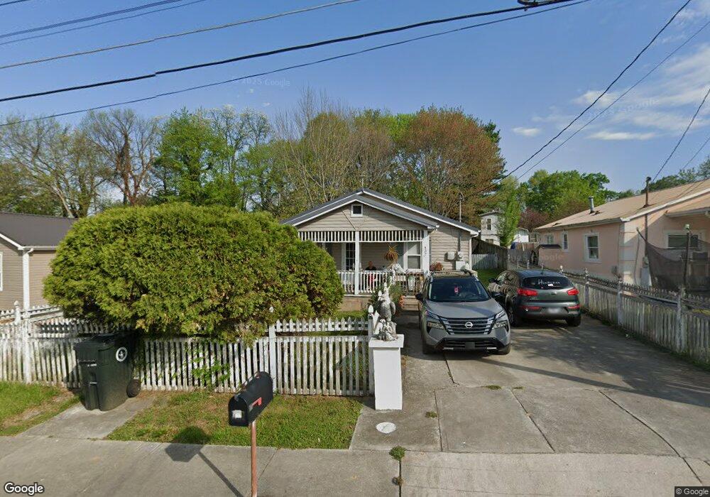
437 Cain Ave Morristown, TN 37813
Estimated Value: $115,677 - $206,000
--
Bed
1
Bath
960
Sq Ft
$175/Sq Ft
Est. Value
About This Home
This home is located at 437 Cain Ave, Morristown, TN 37813 and is currently estimated at $168,419, approximately $175 per square foot. 437 Cain Ave is a home located in Hamblen County with nearby schools including Hillcrest Elementary School, Meadowview Middle School, and Morristown East High School.
Ownership History
Date
Name
Owned For
Owner Type
Purchase Details
Closed on
May 1, 1997
Sold by
Lemuel Carter
Bought by
Donald Choate
Current Estimated Value
Purchase Details
Closed on
Sep 23, 1988
Bought by
Carter Lemuel E and Carter Judy G
Purchase Details
Closed on
Sep 22, 1988
Bought by
Lovin Angela Denise
Purchase Details
Closed on
Mar 6, 1986
Bought by
Lovin Angela Denise
Purchase Details
Closed on
Apr 17, 1980
Bought by
Keasling Hazel Linda L and Keasling E
Purchase Details
Closed on
Oct 24, 1979
Bought by
City Of Morristown
Purchase Details
Closed on
Oct 2, 1979
Bought by
Bank Of Commerce Hamilton Bank & United
Create a Home Valuation Report for This Property
The Home Valuation Report is an in-depth analysis detailing your home's value as well as a comparison with similar homes in the area
Home Values in the Area
Average Home Value in this Area
Purchase History
| Date | Buyer | Sale Price | Title Company |
|---|---|---|---|
| Donald Choate | $23,887 | -- | |
| Carter Lemuel E | $21,000 | -- | |
| Lovin Angela Denise | -- | -- | |
| Lovin Angela Denise | $18,900 | -- | |
| Keasling Hazel Linda L | -- | -- | |
| City Of Morristown | -- | -- | |
| Bank Of Commerce Hamilton Bank & United | -- | -- |
Source: Public Records
Tax History Compared to Growth
Tax History
| Year | Tax Paid | Tax Assessment Tax Assessment Total Assessment is a certain percentage of the fair market value that is determined by local assessors to be the total taxable value of land and additions on the property. | Land | Improvement |
|---|---|---|---|---|
| 2024 | $315 | $17,925 | $3,625 | $14,300 |
| 2023 | $315 | $17,925 | $0 | $0 |
| 2022 | $566 | $17,925 | $3,625 | $14,300 |
| 2021 | $566 | $17,925 | $3,625 | $14,300 |
| 2020 | $565 | $17,925 | $3,625 | $14,300 |
| 2019 | $519 | $15,250 | $3,225 | $12,025 |
| 2018 | $481 | $15,250 | $3,225 | $12,025 |
| 2017 | $473 | $15,250 | $3,225 | $12,025 |
| 2016 | $451 | $15,250 | $3,225 | $12,025 |
| 2015 | $420 | $15,250 | $3,225 | $12,025 |
| 2014 | -- | $15,250 | $3,225 | $12,025 |
| 2013 | -- | $17,175 | $0 | $0 |
Source: Public Records
Map
Nearby Homes
- 417 Cain Ave
- 712 Williams St
- 831 Cave St
- 219 Inman St
- 915 Forgey Ave
- 435 S Hill St
- 819 Choctaw St
- 816 Choctaw St
- 0 Joe Hall Rd Unit 703714
- 525 S Liberty Hill Rd
- 0 S Liberty Hill Rd Unit 703697
- 323 Pauline Ave
- 811 Crescent St
- 1200 Liberty Hall Dr
- 926 E Main St
- 1205 Ledford Ave
- 518 W Hillcrest Dr
- 721 E 1st St N
- 0 Russell Cir
- 721 E 1st North St