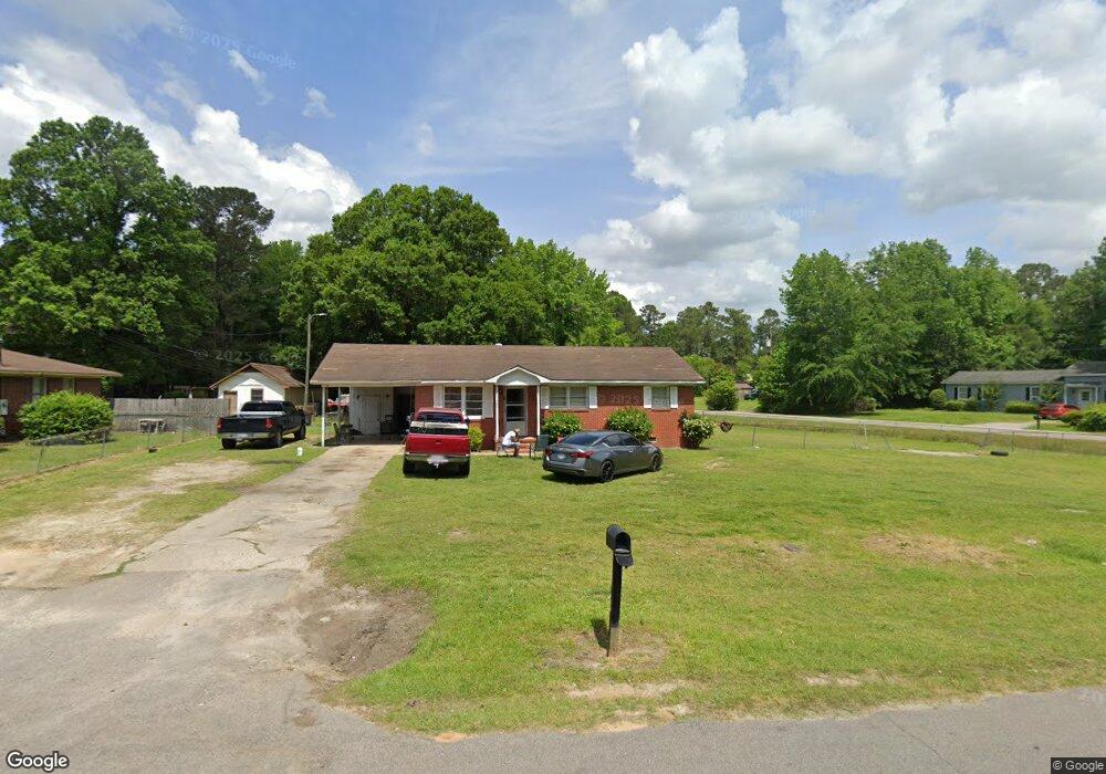
437 Toccoa Dr Manning, SC 29102
Estimated Value: $126,277 - $167,000
3
Beds
2
Baths
1,600
Sq Ft
$90/Sq Ft
Est. Value
About This Home
This home is located at 437 Toccoa Dr, Manning, SC 29102 and is currently estimated at $144,319, approximately $90 per square foot. 437 Toccoa Dr is a home located in Clarendon County with nearby schools including Laurence Manning Academy.
Ownership History
Date
Name
Owned For
Owner Type
Purchase Details
Closed on
Dec 28, 2016
Sold by
King Corie D and Felder Lonzie
Bought by
King Corie and Felder Lonzie
Current Estimated Value
Purchase Details
Closed on
May 8, 2009
Sold by
Haley Charles E and Morris Frances
Bought by
King Corie D and Felder Lonzie
Purchase Details
Closed on
Jan 21, 2009
Sold by
Haley Charles E and Estate Of Mary Alma Haley
Bought by
Haley Charles E and Morris Frances
Create a Home Valuation Report for This Property
The Home Valuation Report is an in-depth analysis detailing your home's value as well as a comparison with similar homes in the area
Home Values in the Area
Average Home Value in this Area
Purchase History
| Date | Buyer | Sale Price | Title Company |
|---|---|---|---|
| King Corie | -- | None Available | |
| King Corie D | $60,000 | None Available | |
| Haley Charles E | -- | None Available |
Source: Public Records
Mortgage History
| Date | Status | Borrower | Loan Amount |
|---|---|---|---|
| Closed | King Corie D | $0 |
Source: Public Records
Tax History
| Year | Tax Paid | Tax Assessment Tax Assessment Total Assessment is a certain percentage of the fair market value that is determined by local assessors to be the total taxable value of land and additions on the property. | Land | Improvement |
|---|---|---|---|---|
| 2025 | $2,560 | $4,170 | $480 | $3,690 |
| 2024 | $2,226 | $4,170 | $480 | $3,690 |
| 2023 | $2,162 | $2,780 | $320 | $2,460 |
| 2022 | $2,136 | $2,780 | $320 | $2,460 |
| 2021 | $2,175 | $4,158 | $480 | $3,678 |
| 2020 | $1,978 | $2,772 | $320 | $2,452 |
| 2019 | $1,919 | $2,772 | $320 | $2,452 |
| 2018 | $1,933 | $4,266 | $0 | $0 |
| 2017 | $770 | $2,844 | $0 | $0 |
| 2016 | $788 | $2,912 | $0 | $0 |
| 2015 | $790 | $3,076 | $320 | $2,756 |
| 2014 | $792 | $3,076 | $320 | $2,756 |
| 2013 | -- | $4,614 | $480 | $4,134 |
Source: Public Records
Map
Nearby Homes
- 408 Toccoa Dr
- 633 Sykes St
- TBD W Huggins St
- 250 Dyson St
- 200 W Boyce St
- 1000 Carolina Way
- TBD Barnwell St
- 126 Hillcrest St
- 617 Pickwood Dr
- 623 Pickwood Dr
- 610 Gib Dr
- TBD S Carolina 260
- 950 Berry St
- 5301 Cypress Pointe #D301
- 22 W End St
- 101 Sumter St
- 138 Nelson Cir
- 202 E Huggins St
- TBD Branchview Dr
- 1107 Long Leaf Dr
- 441 Toccoa Dr
- 445 Toccoa Dr
- 101 Paul Smith Dr
- 425 Toccoa Dr
- 310 Alfred Henry Dr
- 103 Paul Smith Dr
- 428 Toccoa Dr
- 0 Paul Smith Dr
- 317 Alfred Henry Dr
- 313 Alfred Henry St
- 428 Drayton St
- 424 Toccoa Dr
- 309 Alfred Henry Dr
- 421 Toccoa Dr
- 435 Drayton St
- 424 Drayton St
- 433 Drayton St
- 420 Toccoa Dr
- 431 Drayton St
- 305 Alfred Henry Dr
Your Personal Tour Guide
Ask me questions while you tour the home.