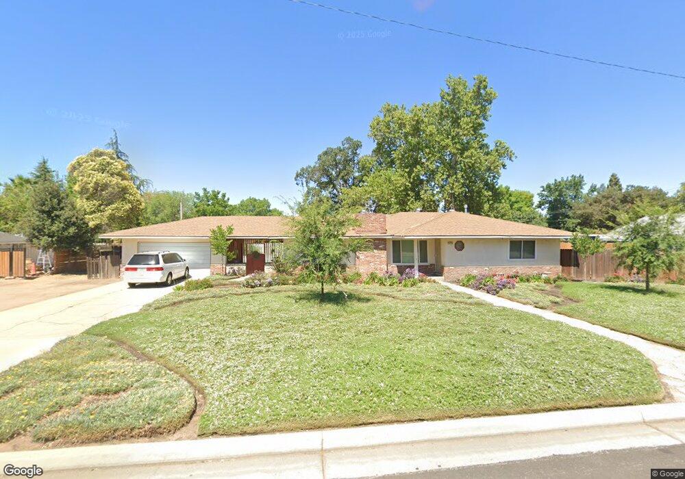
4373 N Delno Ave Fresno, CA 93705
Bullard NeighborhoodEstimated Value: $390,000 - $524,000
3
Beds
2
Baths
1,958
Sq Ft
$238/Sq Ft
Est. Value
About This Home
This home is located at 4373 N Delno Ave, Fresno, CA 93705 and is currently estimated at $465,422, approximately $237 per square foot. 4373 N Delno Ave is a home located in Fresno County with nearby schools including Powers-Ginsburg Elementary, Bullard High School, and Aspen Valley Prep Academy.
Ownership History
Date
Name
Owned For
Owner Type
Purchase Details
Closed on
Mar 29, 2022
Sold by
Florez Martha E
Bought by
Martha E Florez Living Trust and Florez
Current Estimated Value
Purchase Details
Closed on
Sep 11, 2018
Sold by
Florez Charles Martin
Bought by
Florez Martha E
Purchase Details
Closed on
Aug 5, 2013
Sold by
Russell Kenneth H and Russell Dorothy M
Bought by
Russell Linda K and Kenneth H Russell & Dorothy M Russell Tr
Purchase Details
Closed on
Jun 2, 2000
Sold by
Russell Dorothy Mildred
Bought by
Russell Kenneth H
Create a Home Valuation Report for This Property
The Home Valuation Report is an in-depth analysis detailing your home's value as well as a comparison with similar homes in the area
Home Values in the Area
Average Home Value in this Area
Purchase History
| Date | Buyer | Sale Price | Title Company |
|---|---|---|---|
| Martha E Florez Living Trust | -- | Petty Jonathon L | |
| Florez Martha E | -- | North American Title Company | |
| Florez Martha E | $80,000 | North American Title Company | |
| Russell Linda K | -- | None Available | |
| Russell Kenneth H | -- | Fidelity National Title Co |
Source: Public Records
Tax History Compared to Growth
Tax History
| Year | Tax Paid | Tax Assessment Tax Assessment Total Assessment is a certain percentage of the fair market value that is determined by local assessors to be the total taxable value of land and additions on the property. | Land | Improvement |
|---|---|---|---|---|
| 2025 | $3,074 | $245,407 | $72,505 | $172,902 |
| 2023 | $3,015 | $235,880 | $69,691 | $166,189 |
| 2022 | $2,974 | $231,256 | $68,325 | $162,931 |
| 2021 | $2,893 | $226,723 | $66,986 | $159,737 |
| 2020 | $2,880 | $224,400 | $66,300 | $158,100 |
| 2019 | $2,769 | $220,000 | $65,000 | $155,000 |
| 2018 | $1,052 | $89,487 | $12,151 | $77,336 |
| 2017 | $1,032 | $87,733 | $11,913 | $75,820 |
| 2016 | $997 | $86,014 | $11,680 | $74,334 |
| 2015 | $981 | $84,723 | $11,505 | $73,218 |
| 2014 | $959 | $83,064 | $11,280 | $71,784 |
Source: Public Records
Map
Nearby Homes
- 4264 N Holt Ave
- 4246 N Holt Ave
- 4261 N Holt Ave
- 1028 W Holland Ave
- 4366 N Holt Ave
- 1027 W Ashcroft Ave
- 929 W Norwich Ave
- 4306 N Emerson Ave
- 638 W Rialto Ave
- 1245 W Pico Ave
- 4702 N Fruit Ave
- 1484 W Indianapolis Ave
- 1550 W Ashlan Ave Unit 134
- 1550 W Ashlan Ave Unit 229
- 1550 W Ashlan Ave Unit 208
- 1550 W Ashlan Ave Unit 241
- 4156 N Warren Ave
- 4382 N Crystal Ave
- 4446 N Crystal Ave
- 1410 W Rialto Ave
- 4353 N Delno Ave
- 758 W Swift Ave
- 760 W Swift Ave
- 727 W Holland Ave
- 756 W Swift Ave
- 4374 N Delno Ave
- 4350 N Delno Ave
- 4325 N Delno Ave
- 635 W Holland Ave
- 754 W Swift Ave
- 762 W Swift Ave
- 706 W Holland Ave
- 781 W Holland Ave
- 4326 N Delno Ave
- 752 W Swift Ave
- 728 W Holland Ave
- 764 W Swift Ave
- 766 W Swift Ave
- 708 W Swift Ave
- 4371 N Carruth Ave