Estimated Value: $686,034 - $879,000
3
Beds
3
Baths
2,542
Sq Ft
$297/Sq Ft
Est. Value
About This Home
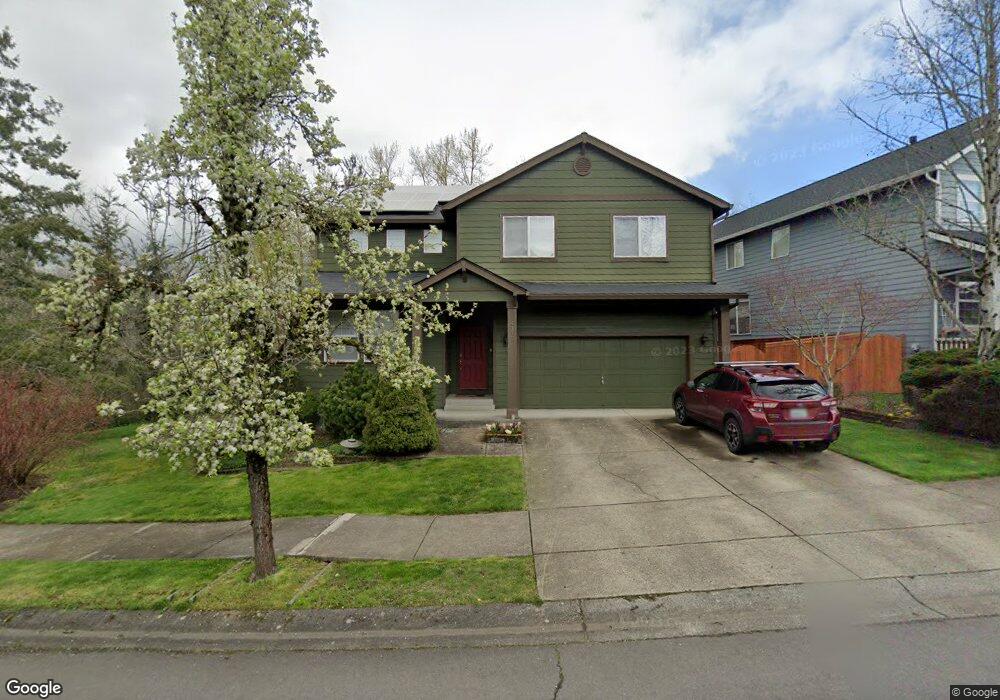
This home is located at 4375 NW 12th Loop, Camas, WA 98607 and is currently estimated at $753,759, approximately $296 per square foot. 4375 NW 12th Loop is a home located in Clark County with nearby schools including Prune Hill Elementary School, Skyridge Middle School, and Camas High School.
Ownership History
Date
Name
Owned For
Owner Type
Purchase Details
Closed on
Dec 21, 2000
Sold by
Apc The Greens Llc
Bought by
Grote Richard F and Grote Jana S
Current Estimated Value
Home Financials for this Owner
Home Financials are based on the most recent Mortgage that was taken out on this home.
Original Mortgage
$187,150
Outstanding Balance
$69,016
Interest Rate
7.71%
Estimated Equity
$684,743
Create a Home Valuation Report for This Property
The Home Valuation Report is an in-depth analysis detailing your home's value as well as a comparison with similar homes in the area
Purchase History
| Date | Buyer | Sale Price | Title Company |
|---|---|---|---|
| Grote Richard F | $233,964 | Fidelity National Title Co |
Source: Public Records
Mortgage History
| Date | Status | Borrower | Loan Amount |
|---|---|---|---|
| Open | Grote Richard F | $187,150 |
Source: Public Records
Tax History
| Year | Tax Paid | Tax Assessment Tax Assessment Total Assessment is a certain percentage of the fair market value that is determined by local assessors to be the total taxable value of land and additions on the property. | Land | Improvement |
|---|---|---|---|---|
| 2025 | $5,729 | $557,432 | $165,000 | $392,432 |
| 2024 | $5,366 | $600,896 | $221,000 | $379,896 |
| 2023 | $5,992 | $605,130 | $213,800 | $391,330 |
| 2022 | $5,594 | $642,657 | $234,632 | $408,025 |
| 2021 | $5,391 | $501,478 | $183,992 | $317,486 |
| 2020 | $5,610 | $447,959 | $165,000 | $282,959 |
| 2019 | $5,296 | $432,261 | $165,000 | $267,261 |
| 2018 | $5,626 | $434,663 | $0 | $0 |
| 2017 | $4,640 | $388,154 | $0 | $0 |
| 2016 | $4,391 | $348,577 | $0 | $0 |
Source: Public Records
Map
Nearby Homes
- 845 NW Sacajawea St
- 4030 NW Quinault St
- 560 NW Brady Rd
- 580 NW Brady Rd
- 0 NW Brady Rd
- 3983 NW 64th Ave Unit 22
- 3983 NW 64th Ave
- 4907 NW Highpoint Dr
- 810 NW Brady Rd
- 1727 NW Ogden St
- 3538 NW 17th Ave
- 3270 NW 17th Ave
- 3308 NW 17th Ave
- 1730 NW Klickitat St
- 3345 NW 14th Ave
- 3321 NW 17th Ave
- 3003 NW 13th Cir
- 3011 NW 13th Cir
- 0 NW Goodwin St
- 1012 NW Goodwin St
- 4363 NW 12th Loop
- 4347 NW 12th Loop
- 4378 NW 12th Loop
- 4354 NW 12th Loop
- 4339 NW 12th Loop
- 4402 NW 12th Loop
- 4342 NW 12th Loop
- 4408 NW 12th Loop
- 4326 NW 12th Loop
- 4323 NW 12th Loop
- 4314 NW 12th Loop
- 4357 NW 12th Ave
- 4311 NW 12th Loop
- 4345 NW 12th Ave
- 4262 NW 12th Loop
- 4412 NW 12th Ave
- 4335 NW 12th Ave
- 4404 NW 12th Ave
- 4259 NW 12th Loop
- 4236 NW 12th Loop
Your Personal Tour Guide
Ask me questions while you tour the home.