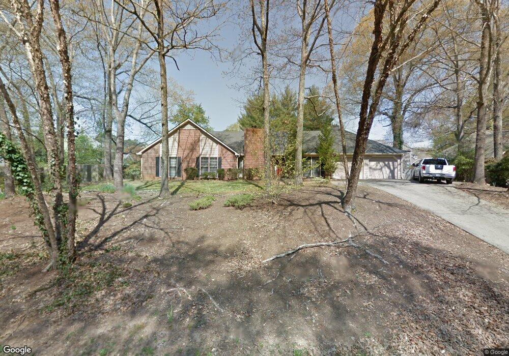
438 Lees Trace SW Marietta, GA 30064
Southwestern Marietta NeighborhoodEstimated Value: $490,808 - $547,000
4
Beds
2
Baths
1,923
Sq Ft
$267/Sq Ft
Est. Value
About This Home
This home is located at 438 Lees Trace SW, Marietta, GA 30064 and is currently estimated at $513,952, approximately $267 per square foot. 438 Lees Trace SW is a home located in Cobb County with nearby schools including A.L. Burruss Elementary School, Marietta Sixth Grade Academy, and Marietta Middle School.
Ownership History
Date
Name
Owned For
Owner Type
Purchase Details
Closed on
Jul 6, 2004
Sold by
Redding James E and Redding Flade
Bought by
Citifinancial Mortgage Co Inc
Current Estimated Value
Purchase Details
Closed on
Apr 8, 1998
Sold by
Allen Barbara G
Bought by
Redding James E and Redding Flade
Home Financials for this Owner
Home Financials are based on the most recent Mortgage that was taken out on this home.
Original Mortgage
$127,200
Interest Rate
10%
Mortgage Type
New Conventional
Create a Home Valuation Report for This Property
The Home Valuation Report is an in-depth analysis detailing your home's value as well as a comparison with similar homes in the area
Home Values in the Area
Average Home Value in this Area
Purchase History
| Date | Buyer | Sale Price | Title Company |
|---|---|---|---|
| Citifinancial Mortgage Co Inc | $178,900 | -- | |
| Redding James E | $159,000 | -- |
Source: Public Records
Mortgage History
| Date | Status | Borrower | Loan Amount |
|---|---|---|---|
| Previous Owner | Redding James E | $127,200 |
Source: Public Records
Tax History Compared to Growth
Tax History
| Year | Tax Paid | Tax Assessment Tax Assessment Total Assessment is a certain percentage of the fair market value that is determined by local assessors to be the total taxable value of land and additions on the property. | Land | Improvement |
|---|---|---|---|---|
| 2025 | $516 | $170,500 | $52,000 | $118,500 |
| 2024 | $516 | $170,500 | $52,000 | $118,500 |
| 2023 | $364 | $157,444 | $40,000 | $117,444 |
| 2022 | $516 | $108,764 | $26,000 | $82,764 |
| 2021 | $530 | $108,764 | $26,000 | $82,764 |
| 2020 | $530 | $108,764 | $26,000 | $82,764 |
| 2019 | $530 | $108,764 | $26,000 | $82,764 |
| 2018 | $528 | $92,400 | $26,000 | $66,400 |
| 2017 | $424 | $92,400 | $26,000 | $66,400 |
| 2016 | $424 | $77,868 | $26,000 | $51,868 |
| 2015 | $464 | $77,868 | $26,000 | $51,868 |
| 2014 | $480 | $77,868 | $0 | $0 |
Source: Public Records
Map
Nearby Homes
- 1161 Rockmann Terrace SW
- 332 Rockmann Ln SW
- 1047 Chestnut Hill Cir SW
- 1121 Cannongate Crossing SW
- 1017 Cannongate Crossing SW
- 1011 Cannongate Crossing SW
- 839 Manning Villas Ct SW
- 916 Cannon Gate Crossing
- 560 Manning Rd SW
- 916 Cannongate Crossing SW Unit 916
- 834 Cannon Run SW
- 838 Cannon Run SW
- 873 Cavalry Dr SW
- 818 Manning Way SW Unit 1
- 1211 Cliffpine Ct SW
- 805 Manning Way SW
- 798 Sentinel Ridge SW
- 1198 Seminary Dr SW
- 950 Laurel Field Ln SW
- 954 Laurel Field Ln SW
- 0 Rockford Pass SW Unit 8690470
- 0 Rockford Pass SW Unit 8782808
- 0 Rockford Pass SW Unit 8173656
- 0 Rockford Pass SW Unit 8367473
- 428 Lees Trace SW
- 431 Lees Trace SW
- 460 Rockford Pass SW
- 958 Laurel Field Ln SW
- 919 Trailside Ln SW
- 920 Trailside Ln SW
- 449 Lees Trace SW
- 0 Laurel Field Ln SW Unit 7247618
- 0 Laurel Field Ln SW Unit 8428010
- 0 Laurel Field Ln SW Unit 8192365
- 0 Laurel Field Ln SW Unit 8163447
- 0 Laurel Field Ln SW Unit 8048264
- 424 Lees Trace SW
- 962 Laurel Field Ln SW