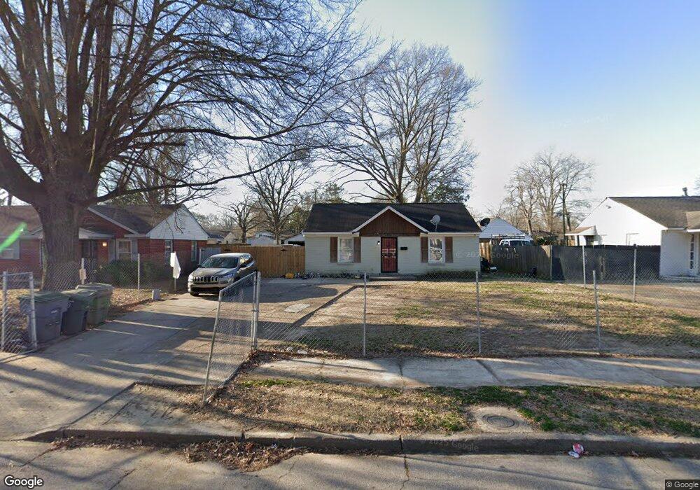
4381 Grey Rd Memphis, TN 38108
Douglass NeighborhoodEstimated Value: $90,873 - $111,000
2
Beds
1
Bath
792
Sq Ft
$124/Sq Ft
Est. Value
About This Home
This home is located at 4381 Grey Rd, Memphis, TN 38108 and is currently estimated at $98,468, approximately $124 per square foot. 4381 Grey Rd is a home located in Shelby County with nearby schools including Wells Station Elementary School, Kingsbury Middle School, and Kingsbury High School.
Ownership History
Date
Name
Owned For
Owner Type
Purchase Details
Closed on
Jul 6, 2012
Sold by
Noah Harolyn W George and Noah Irvin
Bought by
Zavala Pedro and Idrovo Catherine
Current Estimated Value
Home Financials for this Owner
Home Financials are based on the most recent Mortgage that was taken out on this home.
Original Mortgage
$54,355
Interest Rate
3.76%
Mortgage Type
Seller Take Back
Purchase Details
Closed on
Dec 19, 2006
Sold by
Hayes Leah Marie and White Leah Marie
Bought by
Noah Harolyn W George and Noah Irvin
Purchase Details
Closed on
May 15, 2003
Sold by
Lawrence John E and Barnett Marilyn L
Bought by
Hayes Leah Marie
Home Financials for this Owner
Home Financials are based on the most recent Mortgage that was taken out on this home.
Original Mortgage
$49,400
Interest Rate
5.76%
Mortgage Type
Purchase Money Mortgage
Create a Home Valuation Report for This Property
The Home Valuation Report is an in-depth analysis detailing your home's value as well as a comparison with similar homes in the area
Home Values in the Area
Average Home Value in this Area
Purchase History
| Date | Buyer | Sale Price | Title Company |
|---|---|---|---|
| Zavala Pedro | $52,600 | Multiple | |
| Noah Harolyn W George | $46,000 | First Natl Fincl Title Svcs | |
| Hayes Leah Marie | $45,800 | -- |
Source: Public Records
Mortgage History
| Date | Status | Borrower | Loan Amount |
|---|---|---|---|
| Closed | Zavala Pedro | $54,355 | |
| Previous Owner | Hayes Leah Marie | $49,400 |
Source: Public Records
Tax History
| Year | Tax Paid | Tax Assessment Tax Assessment Total Assessment is a certain percentage of the fair market value that is determined by local assessors to be the total taxable value of land and additions on the property. | Land | Improvement |
|---|---|---|---|---|
| 2025 | $295 | $15,500 | $2,750 | $12,750 |
| 2024 | $295 | $8,700 | $1,550 | $7,150 |
| 2023 | $530 | $8,700 | $1,550 | $7,150 |
| 2022 | $530 | $8,700 | $1,550 | $7,150 |
| 2021 | $536 | $8,700 | $1,550 | $7,150 |
| 2020 | $482 | $6,650 | $1,400 | $5,250 |
| 2019 | $482 | $6,650 | $1,400 | $5,250 |
| 2018 | $482 | $6,650 | $1,400 | $5,250 |
| 2017 | $273 | $6,650 | $1,400 | $5,250 |
| 2016 | $536 | $12,275 | $0 | $0 |
| 2014 | $536 | $12,275 | $0 | $0 |
Source: Public Records
Map
Nearby Homes
- 1373 Russwood Rd
- 1332 Wells Station Rd
- 4248 Truman Ave
- 4251 Riviera Rd
- 4233 Riviera Rd
- 4161 Grey Rd
- 1251 Holliday St
- 4117 Grey Rd
- 4113 Truman Ave
- 1241 Holliday St
- 1286 Gherald St
- 4202 Reed Ave
- 4408 Jamerson Rd
- 1236 Darlow St
- 1493 Luverne St
- 1711 Ronda St
- 1771 Wells Station Rd
- 4039 Westover Ave
- 4072 Leroy Ave
- 1710 Mcnair St
Your Personal Tour Guide
Ask me questions while you tour the home.