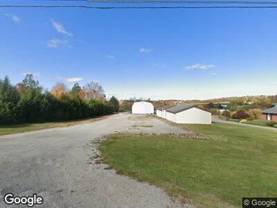
4387 State Route 981 Mount Pleasant, PA 15666
Mount Pleasant Township NeighborhoodEstimated Value: $183,335 - $226,000
--
Bed
--
Bath
1,054
Sq Ft
$191/Sq Ft
Est. Value
About This Home
This home is located at 4387 State Route 981, Mount Pleasant, PA 15666 and is currently estimated at $201,334, approximately $191 per square foot. 4387 State Route 981 is a home located in Westmoreland County with nearby schools including Mount Pleasant Area High School and Trauger Mennonite Church School.
Ownership History
Date
Name
Owned For
Owner Type
Purchase Details
Closed on
Jul 21, 2017
Sold by
Sosko Jeffrey S and Sosko Judy
Bought by
Hutchinson Micholas R and Hutchinson Alicia L
Current Estimated Value
Home Financials for this Owner
Home Financials are based on the most recent Mortgage that was taken out on this home.
Original Mortgage
$90,000
Interest Rate
4.5%
Mortgage Type
New Conventional
Purchase Details
Closed on
Jun 17, 2013
Sold by
Sosko Joseph J and Sosko Judith A
Bought by
Sosko Jeffrey S
Create a Home Valuation Report for This Property
The Home Valuation Report is an in-depth analysis detailing your home's value as well as a comparison with similar homes in the area
Home Values in the Area
Average Home Value in this Area
Purchase History
| Date | Buyer | Sale Price | Title Company |
|---|---|---|---|
| Hutchinson Micholas R | $120,000 | None Available | |
| Sosko Jeffrey S | -- | None Available |
Source: Public Records
Mortgage History
| Date | Status | Borrower | Loan Amount |
|---|---|---|---|
| Previous Owner | Hutchinson Micholas R | $90,000 | |
| Previous Owner | Sosko Jeffrey S | $41,900 |
Source: Public Records
Tax History Compared to Growth
Tax History
| Year | Tax Paid | Tax Assessment Tax Assessment Total Assessment is a certain percentage of the fair market value that is determined by local assessors to be the total taxable value of land and additions on the property. | Land | Improvement |
|---|---|---|---|---|
| 2025 | $2,498 | $19,870 | $2,010 | $17,860 |
| 2024 | $2,478 | $19,870 | $2,010 | $17,860 |
| 2023 | $2,319 | $19,870 | $2,010 | $17,860 |
| 2022 | $2,319 | $19,870 | $2,010 | $17,860 |
| 2021 | $2,280 | $19,870 | $2,010 | $17,860 |
| 2020 | $2,280 | $19,870 | $2,010 | $17,860 |
| 2019 | $2,270 | $19,970 | $2,110 | $17,860 |
| 2018 | $2,281 | $19,970 | $2,110 | $17,860 |
| 2017 | $2,237 | $19,970 | $2,110 | $17,860 |
| 2016 | $2,139 | $19,970 | $2,110 | $17,860 |
| 2015 | $2,139 | $19,970 | $2,110 | $17,860 |
| 2014 | $2,061 | $19,970 | $2,110 | $17,860 |
Source: Public Records
Map
Nearby Homes
- 6073 Pennsylvania 981
- 312 Lauraine Ct
- 312 Lauraine Ct
- 102 Sharon Dr
- 142 Sharon Dr
- 794 Blacksmith Rd
- 1 Fitch Ln
- 317 Lauraine Ct
- 2741 Pa-982
- 320 Morningside Dr
- 2697 Route 982
- 1757 Mount Pleasant Rd
- LOT 118 Lentz Rd
- 3827 State Route 981
- 3388 Pennsylvania 982
- 437 Lemmon Rd
- 418 Lemmon Rd
- 1441 State Route 130
- 8 Spring Run Rd
- 612 Westshire Dr
- 4387 State Route 981
- 4393 State Route 981
- 4393 State Route 981
- 125 Pollins Rd
- 125 Pollins Rd
- 106 Pollins Rd
- 120 Pollins Rd
- 135 Pollins Rd
- 102 Pollins Rd
- 1004 1st St
- 4415 State Route 981
- 4412 State Route 981
- 1009 1st St
- 1009 1st St
- 148 Pollins Rd
- 1015 1st St
- 163 Pollins Rd
- 4426 State Route 981
- 154 Pollins Rd
- 1017 1st St
