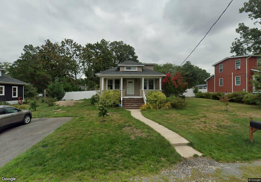
439 Harding Ave Odenton, MD 21113
Estimated Value: $295,000
--
Bed
1
Bath
1,519
Sq Ft
$194/Sq Ft
Est. Value
About This Home
This home is located at 439 Harding Ave, Odenton, MD 21113 and is currently priced at $295,000, approximately $194 per square foot. 439 Harding Ave is a home located in Anne Arundel County with nearby schools including Odenton Elementary School, Arundel Middle School, and Arundel High School.
Ownership History
Date
Name
Owned For
Owner Type
Purchase Details
Closed on
Feb 21, 2017
Sold by
Morrison Mary Angela and Glover Karen Lee
Bought by
Glover Karen Lee
Current Estimated Value
Home Financials for this Owner
Home Financials are based on the most recent Mortgage that was taken out on this home.
Original Mortgage
$122,700
Outstanding Balance
$101,874
Interest Rate
4.3%
Mortgage Type
New Conventional
Purchase Details
Closed on
Nov 30, 2012
Sold by
Wade Carol and Estate Of Wilbur C Wade Iii
Bought by
Glover Karen Lee and Morrison Angela
Purchase Details
Closed on
Dec 3, 2001
Sold by
Wade Wilbur C
Bought by
Wade Mary K
Create a Home Valuation Report for This Property
The Home Valuation Report is an in-depth analysis detailing your home's value as well as a comparison with similar homes in the area
Home Values in the Area
Average Home Value in this Area
Purchase History
| Date | Buyer | Sale Price | Title Company |
|---|---|---|---|
| Glover Karen Lee | $122,700 | None Available | |
| Glover Karen Lee | $55,000 | Aegis Title Associates Llc | |
| Wade Mary K | -- | -- |
Source: Public Records
Mortgage History
| Date | Status | Borrower | Loan Amount |
|---|---|---|---|
| Open | Glover Karen Lee | $122,700 |
Source: Public Records
Tax History Compared to Growth
Tax History
| Year | Tax Paid | Tax Assessment Tax Assessment Total Assessment is a certain percentage of the fair market value that is determined by local assessors to be the total taxable value of land and additions on the property. | Land | Improvement |
|---|---|---|---|---|
| 2025 | $3,713 | $315,400 | $232,300 | $83,100 |
| 2024 | $3,713 | $295,500 | $0 | $0 |
| 2023 | $3,459 | $275,600 | $0 | $0 |
| 2022 | $3,079 | $255,700 | $232,300 | $23,400 |
| 2021 | $6,159 | $255,700 | $232,300 | $23,400 |
| 2020 | $3,028 | $255,700 | $232,300 | $23,400 |
| 2019 | $3,218 | $273,600 | $250,200 | $23,400 |
| 2018 | $2,630 | $259,367 | $0 | $0 |
| 2017 | $2,863 | $245,133 | $0 | $0 |
| 2016 | -- | $230,900 | $0 | $0 |
| 2015 | -- | $230,900 | $0 | $0 |
| 2014 | -- | $230,900 | $0 | $0 |
Source: Public Records
Map
Nearby Homes
- 1230 Breitwert Ave
- 1250 Breitwert Ave
- 654 Lions Gate Ln
- 488 Bruce Ave
- 606 Moonglow Rd
- 602 Moonglow Rd Unit 202
- 602 Moonglow Rd Unit 304
- 546 Greencrest Ln
- 363 Baltimore Ave
- 604 Rolling Hill Walk Unit 103
- 508 Greencrest Ln
- 608 Rolling Hill Walk Unit 304
- 521 Realm Ct E Unit 11-68
- 506 Imperial Square
- 328 Council Oak Dr
- 357 Council Oak Dr
- 530 Rita Dr
- 655 Realm Ct W
- 1327 Cheswick Ln Unit 103
- 1212 Chadwell Ct
- 441 Harding Ave
- 437 Harding Ave
- 1223 Brietwert Ave
- 1204 Breitwert Ave
- 1230 Annapolis Rd
- 1241 Breitwert Ave
- 1217 Brietwert Ave
- 1245 Breitwert Ave
- 1245A Breitwert Ave
- 1245A Breitwert Ave
- 442 Harding Ave
- 438 Harding Ave
- 1230 Brietwert Ave
- 1238 Brietwert Ave
- 1226 Annapolis Rd
- 444 Harding Ave
- 1238 Annapolis Rd
- 1215 Breitwert Ave
- 1215 Brietwert Ave
- 1240 Brietwert Ave