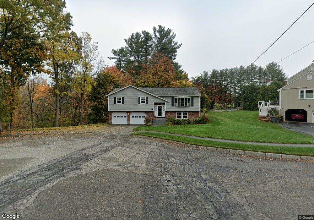
44 Indian Tree Ln Reading, MA 01867
Estimated Value: $1,041,099 - $1,136,000
3
Beds
3
Baths
2,167
Sq Ft
$496/Sq Ft
Est. Value
About This Home
This home is located at 44 Indian Tree Ln, Reading, MA 01867 and is currently estimated at $1,075,525, approximately $496 per square foot. 44 Indian Tree Ln is a home located in Middlesex County with nearby schools including Joshua Eaton Elementary School, Walter S. Parker Middle School, and Reading Memorial High School.
Ownership History
Date
Name
Owned For
Owner Type
Purchase Details
Closed on
Mar 19, 1998
Sold by
Phinney Allison and Phinney Janet B
Bought by
Dynan Paul and Dynan Meghan A
Current Estimated Value
Home Financials for this Owner
Home Financials are based on the most recent Mortgage that was taken out on this home.
Original Mortgage
$225,000
Outstanding Balance
$33,191
Interest Rate
6.92%
Mortgage Type
Purchase Money Mortgage
Estimated Equity
$1,042,334
Create a Home Valuation Report for This Property
The Home Valuation Report is an in-depth analysis detailing your home's value as well as a comparison with similar homes in the area
Home Values in the Area
Average Home Value in this Area
Purchase History
| Date | Buyer | Sale Price | Title Company |
|---|---|---|---|
| Dynan Paul | $317,500 | -- | |
| Dynan Paul F | $317,500 | -- |
Source: Public Records
Mortgage History
| Date | Status | Borrower | Loan Amount |
|---|---|---|---|
| Open | Dynan Paul F | $225,000 | |
| Closed | Dynan Paul F | $225,000 |
Source: Public Records
Tax History
| Year | Tax Paid | Tax Assessment Tax Assessment Total Assessment is a certain percentage of the fair market value that is determined by local assessors to be the total taxable value of land and additions on the property. | Land | Improvement |
|---|---|---|---|---|
| 2025 | $10,915 | $958,300 | $556,300 | $402,000 |
| 2024 | $11,048 | $942,700 | $547,200 | $395,500 |
| 2023 | $10,398 | $825,900 | $479,400 | $346,500 |
| 2022 | $10,385 | $779,100 | $452,300 | $326,800 |
| 2021 | $10,127 | $733,300 | $413,800 | $319,500 |
| 2020 | $9,727 | $697,300 | $393,500 | $303,800 |
| 2019 | $9,323 | $655,200 | $369,700 | $285,500 |
| 2018 | $4,832 | $613,200 | $346,000 | $267,200 |
| 2017 | $4,464 | $618,400 | $339,200 | $279,200 |
| 2016 | $8,777 | $605,300 | $307,800 | $297,500 |
| 2015 | $8,125 | $552,700 | $281,100 | $271,600 |
| 2014 | $8,067 | $547,300 | $278,300 | $269,000 |
Source: Public Records
Map
Nearby Homes
- 103 Oak St
- 133 Pine Ridge Rd
- 33 Old Farm Rd
- 29 Louanis Dr
- 20 Pinevale Ave
- 100 Prescott St
- 75 Whitehall Ln
- 349 South St
- 241 Main St Unit C3
- 313 South St
- 7 Augustus Ct Unit 1013
- 84 Curtis St
- 355 South St
- 1 Garvey Rd Unit 1
- 26 Lothrop Rd
- 37 Fremont St
- 5 Washington St Unit D4
- 101 King St Unit 101
- 1010 Gazebo Cir
- 51 Winslow Rd
- 119 Red Gate Ln
- 111 Red Gate Ln
- 43 Indian Tree Ln
- 47 Indian Tree Ln
- 37 Indian Tree Ln
- 105 Red Gate Ln
- 118 Red Gate Ln
- 31 Indian Tree Ln
- 1 Indiana Ave
- 3 Indiana Ave
- 97 Red Gate Ln
- 112 Red Gate Ln
- 24 Indian Tree Ln
- 7 Indiana Ave
- 25 Indian Tree Ln
- 106 Red Gate Ln
- 11 Indiana Ave
- 27 California Rd
- 100 Red Gate Ln
- 89 Red Gate Ln
Your Personal Tour Guide
Ask me questions while you tour the home.