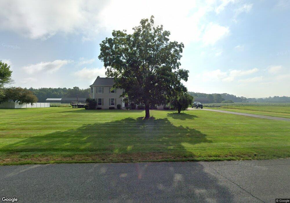
44 Shattuck Rd Hadley, MA 01035
Estimated Value: $698,326 - $728,000
4
Beds
3
Baths
2,632
Sq Ft
$272/Sq Ft
Est. Value
About This Home
This home is located at 44 Shattuck Rd, Hadley, MA 01035 and is currently estimated at $716,582, approximately $272 per square foot. 44 Shattuck Rd is a home located in Hampshire County with nearby schools including Hadley Elementary School and Hopkins Academy.
Ownership History
Date
Name
Owned For
Owner Type
Purchase Details
Closed on
Sep 27, 2017
Sold by
Kotfila Regina J
Bought by
Kotfila Stephen G and Kotfila Regina J
Current Estimated Value
Purchase Details
Closed on
Dec 14, 2006
Sold by
Kokoski Elaine A and Kokoski John H
Bought by
Tudryn James P and Kotfila Regina J
Purchase Details
Closed on
Oct 13, 2005
Sold by
Tudryn James P and Kotfila Regina J
Bought by
Kokoski Elaine A and Kokoski John H
Create a Home Valuation Report for This Property
The Home Valuation Report is an in-depth analysis detailing your home's value as well as a comparison with similar homes in the area
Home Values in the Area
Average Home Value in this Area
Purchase History
| Date | Buyer | Sale Price | Title Company |
|---|---|---|---|
| Kotfila Stephen G | -- | -- | |
| Tudryn James P | -- | -- | |
| Kokoski Elaine A | $330,000 | -- |
Source: Public Records
Tax History
| Year | Tax Paid | Tax Assessment Tax Assessment Total Assessment is a certain percentage of the fair market value that is determined by local assessors to be the total taxable value of land and additions on the property. | Land | Improvement |
|---|---|---|---|---|
| 2025 | $6,997 | $601,600 | $144,500 | $457,100 |
| 2024 | $6,714 | $589,500 | $144,500 | $445,000 |
| 2023 | $6,419 | $556,200 | $144,500 | $411,700 |
| 2022 | $5,850 | $480,300 | $144,500 | $335,800 |
| 2021 | $5,686 | $473,800 | $144,500 | $329,300 |
| 2020 | $5,755 | $450,300 | $144,500 | $305,800 |
| 2019 | $5,566 | $450,300 | $144,500 | $305,800 |
| 2018 | $5,444 | $450,300 | $144,500 | $305,800 |
| 2017 | $5,128 | $443,200 | $144,500 | $298,700 |
| 2016 | $4,942 | $443,200 | $144,500 | $298,700 |
| 2015 | $4,813 | $443,200 | $144,500 | $298,700 |
| 2014 | $4,716 | $443,200 | $144,500 | $298,700 |
Source: Public Records
Map
Nearby Homes
- 3 Frost Ln
- 6 Shattuck Rd
- 38 S Plain Rd
- Lot 3 Roosevelt St
- 167 Rolling Ridge Rd
- 12 Teawaddle Ln
- 185 Cherry Ln
- Lot 3A-3 Leverett Rd
- 0 Henry St
- Lot A Kingman Rd
- 113 Juggler Meadow Rd
- 59 N Hatfield Rd
- 10 Depot Rd
- 0 Straits Rd
- 75 Amity Place Unit 75
- 63 Amity Place Unit 63
- 174 Lincoln Ave
- 60 Red Gate Ln
- 0 Main St
- 0 Red Gate Ln Unit 73348273
Your Personal Tour Guide
Ask me questions while you tour the home.