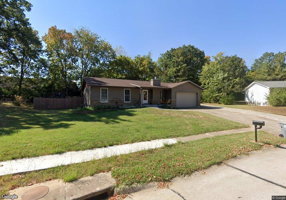
44 Westbrook Dr O Fallon, MO 63366
Estimated Value: $275,140 - $313,000
3
Beds
3
Baths
1,064
Sq Ft
$274/Sq Ft
Est. Value
About This Home
This home is located at 44 Westbrook Dr, O Fallon, MO 63366 and is currently estimated at $291,285, approximately $273 per square foot. 44 Westbrook Dr is a home located in St. Charles County with nearby schools including Joseph L. Mudd Elementary School, Forest Park Elementary School, and Fort Zumwalt North Middle School.
Ownership History
Date
Name
Owned For
Owner Type
Purchase Details
Closed on
Dec 7, 2015
Sold by
Smith Debra Y and Woodard Debra Y
Bought by
Smith Debra Y
Current Estimated Value
Home Financials for this Owner
Home Financials are based on the most recent Mortgage that was taken out on this home.
Original Mortgage
$15,000
Interest Rate
3.88%
Mortgage Type
Stand Alone Second
Purchase Details
Closed on
Nov 16, 2001
Sold by
Woodard Richard E
Bought by
Woodard Debra Y
Home Financials for this Owner
Home Financials are based on the most recent Mortgage that was taken out on this home.
Original Mortgage
$108,000
Interest Rate
6.54%
Create a Home Valuation Report for This Property
The Home Valuation Report is an in-depth analysis detailing your home's value as well as a comparison with similar homes in the area
Home Values in the Area
Average Home Value in this Area
Purchase History
| Date | Buyer | Sale Price | Title Company |
|---|---|---|---|
| Smith Debra Y | -- | Freedom Title | |
| Woodard Debra Y | -- | -- |
Source: Public Records
Mortgage History
| Date | Status | Borrower | Loan Amount |
|---|---|---|---|
| Closed | Smith Debra Y | $15,000 | |
| Closed | Woodard Debra Y | $108,000 |
Source: Public Records
Tax History
| Year | Tax Paid | Tax Assessment Tax Assessment Total Assessment is a certain percentage of the fair market value that is determined by local assessors to be the total taxable value of land and additions on the property. | Land | Improvement |
|---|---|---|---|---|
| 2025 | $2,566 | $43,359 | -- | -- |
| 2024 | $2,566 | $38,570 | -- | -- |
| 2023 | $2,567 | $38,570 | -- | -- |
| 2022 | $2,182 | $30,426 | $0 | $0 |
| 2021 | $2,183 | $30,426 | $0 | $0 |
| 2020 | $2,210 | $29,911 | $0 | $0 |
| 2019 | $2,215 | $29,911 | $0 | $0 |
| 2018 | $1,995 | $25,698 | $0 | $0 |
| 2017 | $1,962 | $25,698 | $0 | $0 |
| 2016 | $1,712 | $22,331 | $0 | $0 |
| 2015 | $1,592 | $22,331 | $0 | $0 |
| 2014 | $1,647 | $22,729 | $0 | $0 |
Source: Public Records
Map
Nearby Homes
- 0 Montbrook Dr
- 731 Cordes St
- 38 Downing St
- 151 N Wellington St
- 4 Shinnecock Hills
- 11 Southern Hills Ct
- 734 Sunset Ln
- 10 Southern Hills Ct
- 962 Midpoint Dr
- 423 Woodlawn Ave
- 1117 Turtle Creek Dr
- 24 Hawthorne Ct
- 849 Elaine Dr
- 116 Columbia Meadows Ln
- 127 Columbia Meadows Ln
- 5 Challenger Ct
- 136 Columbia Meadows Ln
- 4 Challenger Ct
- 1 Grand Columbia @ Columbia Meadows
- 1 Columbia @ Columbia Meadows
- 42 Westbrook Dr
- 46 Westbrook Dr
- 43 Westbrook Dr
- 41 Westbrook Dr
- 40 Westbrook Dr
- 48 Westbrook Dr
- 819 W Terra Ln
- 37 Westbrook Dr
- 38 Westbrook Dr
- 51 Westbrook Dr
- 35 Shadybrook Ct
- 50 Westbrook Dr
- 1 Tbb @ Saybrook
- 36 Westbrook Dr
- 53 Westbrook Dr
- 52 Westbrook Dr
- 33 Shadybrook Ct
- 34 Brookside Ct
- 820 W Terra Ln
- 22 Cowan Ln
Your Personal Tour Guide
Ask me questions while you tour the home.