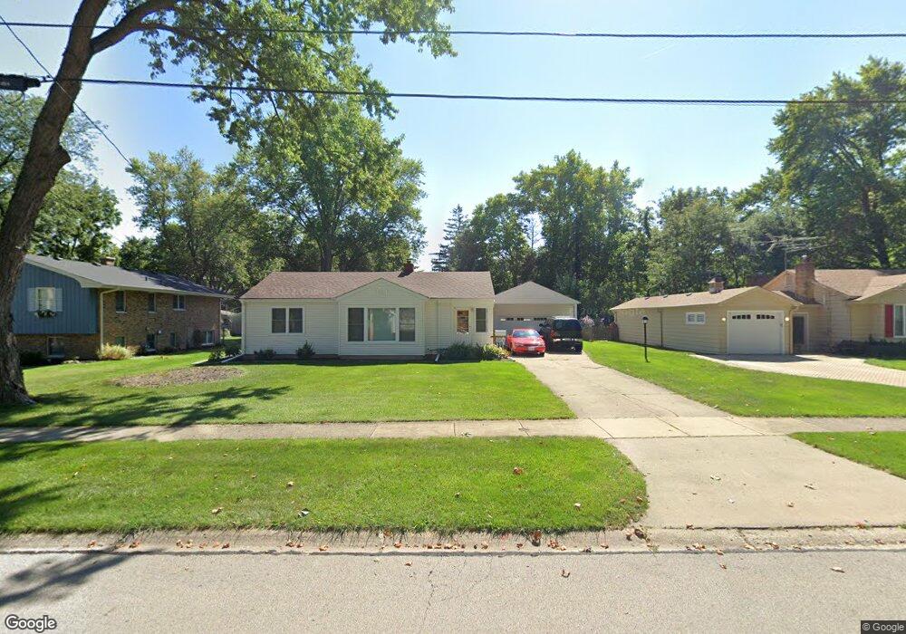
440 Laurel St Batavia, IL 60510
Southeast Batavia NeighborhoodEstimated Value: $270,513 - $349,000
3
Beds
--
Bath
1,099
Sq Ft
$284/Sq Ft
Est. Value
About This Home
This home is located at 440 Laurel St, Batavia, IL 60510 and is currently estimated at $311,878, approximately $283 per square foot. 440 Laurel St is a home located in Kane County with nearby schools including J B Nelson Elementary School, Sam Rotolo Middle School, and Batavia Sr High School.
Ownership History
Date
Name
Owned For
Owner Type
Purchase Details
Closed on
Mar 17, 2023
Sold by
Melewski Michael J
Bought by
Michael J Melewski Living Trust
Current Estimated Value
Purchase Details
Closed on
Feb 15, 2001
Sold by
Lythcke Melewski April R
Bought by
Melewski Michael J
Purchase Details
Closed on
Dec 15, 1994
Sold by
Nichols Marikay
Bought by
Milewski Michael J and Lythcke Melewski April R
Home Financials for this Owner
Home Financials are based on the most recent Mortgage that was taken out on this home.
Original Mortgage
$117,000
Interest Rate
9.24%
Create a Home Valuation Report for This Property
The Home Valuation Report is an in-depth analysis detailing your home's value as well as a comparison with similar homes in the area
Home Values in the Area
Average Home Value in this Area
Purchase History
| Date | Buyer | Sale Price | Title Company |
|---|---|---|---|
| Michael J Melewski Living Trust | -- | -- | |
| Melewski Michael J | -- | Chicago Title Insurance Co | |
| Milewski Michael J | $123,500 | Chicago Title Insurance Co |
Source: Public Records
Mortgage History
| Date | Status | Borrower | Loan Amount |
|---|---|---|---|
| Previous Owner | Milewski Michael J | $117,000 |
Source: Public Records
Tax History
| Year | Tax Paid | Tax Assessment Tax Assessment Total Assessment is a certain percentage of the fair market value that is determined by local assessors to be the total taxable value of land and additions on the property. | Land | Improvement |
|---|---|---|---|---|
| 2024 | $5,443 | $76,840 | $26,840 | $50,000 |
| 2023 | $5,791 | $75,486 | $24,360 | $51,126 |
| 2022 | $5,126 | $64,703 | $22,766 | $41,937 |
| 2021 | $4,908 | $61,364 | $21,591 | $39,773 |
| 2020 | $4,782 | $60,184 | $21,176 | $39,008 |
| 2019 | $4,694 | $58,053 | $20,426 | $37,627 |
| 2018 | $4,497 | $55,842 | $19,648 | $36,194 |
| 2017 | $4,379 | $62,392 | $27,011 | $35,381 |
| 2016 | $5,029 | $60,574 | $26,224 | $34,350 |
| 2015 | -- | $59,195 | $25,627 | $33,568 |
| 2014 | -- | $57,331 | $24,820 | $32,511 |
| 2013 | -- | $62,297 | $30,420 | $31,877 |
Source: Public Records
Map
Nearby Homes
- 304 S Prairie St
- 414 Cleveland Ave
- 694 Hart Rd
- 637 E Wilson St
- Lot 4 Manchester Ave
- Lot 1 Center St
- 860 S River St
- 121 S Raddant Rd
- 701 Viking Dr
- 1025 E Wilson St
- 404 S Batavia Ave
- 417 N Van Buren St
- 330 First St
- 820 N Van Buren St
- 345 Main St
- 1136 Pine Ct
- 524 N College St
- 570 Violet Ln
- 637 Madison St
- 1220 Davey Dr
Your Personal Tour Guide
Ask me questions while you tour the home.