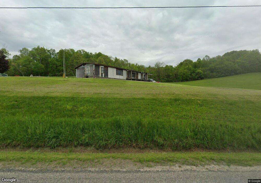
4400 Lower Bloomfield Rd New Concord, OH 43762
Estimated Value: $79,000 - $252,000
--
Bed
--
Bath
--
Sq Ft
7.02
Acres
About This Home
This home is located at 4400 Lower Bloomfield Rd, New Concord, OH 43762 and is currently estimated at $165,500. 4400 Lower Bloomfield Rd is a home located in Muskingum County with nearby schools including New Concord Elementary School, Larry Miller Intermediate Elementary School, and East Muskingum Middle School.
Ownership History
Date
Name
Owned For
Owner Type
Purchase Details
Closed on
Jul 14, 2017
Sold by
Davis Jeff
Bought by
Babcock Brian S and Babcock Stephanie
Current Estimated Value
Home Financials for this Owner
Home Financials are based on the most recent Mortgage that was taken out on this home.
Original Mortgage
$71,770
Outstanding Balance
$59,645
Interest Rate
3.9%
Mortgage Type
Unknown
Estimated Equity
$105,855
Purchase Details
Closed on
Feb 14, 2006
Sold by
Davis Richard L
Bought by
Davis Jeff
Purchase Details
Closed on
Sep 8, 1997
Sold by
Bell Elnora R
Bought by
Davis Richard L
Create a Home Valuation Report for This Property
The Home Valuation Report is an in-depth analysis detailing your home's value as well as a comparison with similar homes in the area
Home Values in the Area
Average Home Value in this Area
Purchase History
| Date | Buyer | Sale Price | Title Company |
|---|---|---|---|
| Babcock Brian S | $31,000 | None Available | |
| Davis Jeff | -- | None Available | |
| Davis Richard L | $14,500 | -- |
Source: Public Records
Mortgage History
| Date | Status | Borrower | Loan Amount |
|---|---|---|---|
| Open | Babcock Brian S | $71,770 |
Source: Public Records
Tax History Compared to Growth
Tax History
| Year | Tax Paid | Tax Assessment Tax Assessment Total Assessment is a certain percentage of the fair market value that is determined by local assessors to be the total taxable value of land and additions on the property. | Land | Improvement |
|---|---|---|---|---|
| 2024 | $1,045 | $17,955 | $13,580 | $4,375 |
| 2023 | $813 | $14,070 | $9,835 | $4,235 |
| 2022 | $500 | $14,070 | $9,835 | $4,235 |
| 2021 | $494 | $14,070 | $9,835 | $4,235 |
| 2020 | $443 | $12,250 | $8,540 | $3,710 |
| 2019 | $441 | $12,250 | $8,540 | $3,710 |
| 2017 | $437 | $11,515 | $7,770 | $3,745 |
| 2016 | $438 | $12,110 | $8,190 | $3,920 |
| 2015 | $471 | $12,110 | $8,190 | $3,920 |
| 2013 | $509 | $12,110 | $8,190 | $3,920 |
Source: Public Records
Map
Nearby Homes
- 5580 Friendship Dr
- 0 Norfield Unit 5124761
- 12985 John Glenn School Rd
- 1165 Friendship Dr
- 53 Paden Rd
- 930 Friendship Dr
- 760 Friendship Dr
- 2895 N Moose Eye Rd
- 154 Montgomery Blvd
- 112 Thompson Ave
- 64895 Lovers Lane Rd
- 6825 Barr Rd
- 8 E Main St
- 67 E Main St
- 1420 Glenn Hwy
- 60936 Patch Rd
- 0 Maple Ln
- Lot 18 & 19 Greenbriar Dr
- 225 Homestead Dr
- 61220 Kadon Dr
- 4810 Lower Bloomfield Rd
- 4900 Lower Bloomfield Rd
- 4360 Lower Bloomfield Rd
- 5095 Lower Bloomfield Rd
- 4375 Lower Bloomfield Rd
- 4345 Lower Bloomfield Rd
- 5220 Friendship Dr
- 5245 Mcbride Dr
- 5405 Mcbride Dr
- 5405 Mcbride Dr
- 5300 Lower Bloomfield Rd
- 5405 Lower Bloomfield Rd
- 5405 Lower Bloomfield Rd
- 4340 Lower Bloomfield Rd
- 3940 Elbert Ln
- 5050 Friendship Dr
- 13150 Ruby Rd
- 5445 Mcbride Dr
- 5525 Lower Bloomfield Rd
- 5645 Lower Bloomfield Rd