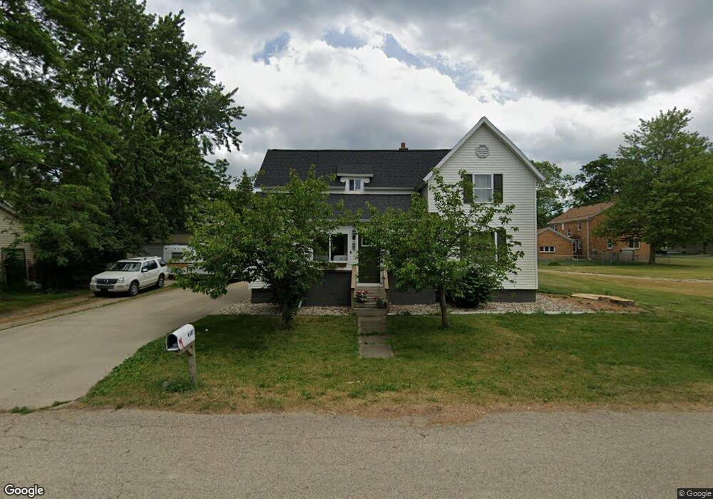
4407 Kemp St Wayland, MI 49348
Estimated Value: $253,000 - $333,000
4
Beds
2
Baths
1,618
Sq Ft
$178/Sq Ft
Est. Value
About This Home
This home is located at 4407 Kemp St, Wayland, MI 49348 and is currently estimated at $287,635, approximately $177 per square foot. 4407 Kemp St is a home located in Allegan County with nearby schools including Wayland High School and Moline Christian School.
Ownership History
Date
Name
Owned For
Owner Type
Purchase Details
Closed on
Sep 4, 2008
Sold by
Burmania Mark A and Burmania Anita M
Bought by
The Bank Of New York Mellon Trust Co Na
Current Estimated Value
Purchase Details
Closed on
Jul 21, 1995
Sold by
Tiemeyer Douglas and Tiemeyer Carol
Bought by
Sloan Brett
Create a Home Valuation Report for This Property
The Home Valuation Report is an in-depth analysis detailing your home's value as well as a comparison with similar homes in the area
Home Values in the Area
Average Home Value in this Area
Purchase History
| Date | Buyer | Sale Price | Title Company |
|---|---|---|---|
| The Bank Of New York Mellon Trust Co Na | $93,817 | None Available | |
| Sloan Brett | $46,000 | -- | |
| Burmania Mark | $60,000 | -- |
Source: Public Records
Tax History Compared to Growth
Tax History
| Year | Tax Paid | Tax Assessment Tax Assessment Total Assessment is a certain percentage of the fair market value that is determined by local assessors to be the total taxable value of land and additions on the property. | Land | Improvement |
|---|---|---|---|---|
| 2025 | $3,331 | $84,200 | $25,700 | $58,500 |
| 2024 | $3,115 | $84,200 | $25,300 | $58,900 |
| 2023 | $3,169 | $75,800 | $24,100 | $51,700 |
| 2022 | $3,115 | $58,500 | $18,400 | $40,100 |
| 2021 | $2,971 | $54,900 | $17,500 | $37,400 |
| 2020 | $2,065 | $54,900 | $17,500 | $37,400 |
| 2019 | $2,065 | $50,000 | $13,200 | $36,800 |
| 2018 | $2,030 | $47,100 | $14,000 | $33,100 |
| 2017 | $0 | $48,000 | $12,500 | $35,500 |
| 2016 | $0 | $41,600 | $12,500 | $29,100 |
| 2015 | -- | $41,600 | $12,500 | $29,100 |
| 2014 | -- | $42,400 | $11,500 | $30,900 |
| 2013 | -- | $41,400 | $11,500 | $29,900 |
Source: Public Records
Map
Nearby Homes
- 4351 Hickory View Ct
- 4335 Tavistock Dr
- 4316 Sussex Place
- Lot 11 Walnut Dale Dr
- 4273 Highpoint Dr Unit 112
- Unit 111 Highpoint Dr
- 4274 Butternut Dr
- Lot 142 Butternut Dr
- Lot 141 Butternut Dr
- 4249 Butternut Dr
- 4240 Butternut Dr
- Vienna Plan at Harvest Meadows
- Charlotte Plan at Harvest Meadows
- Sierra Plan at Harvest Meadows
- Karolynn Plan at Harvest Meadows
- Reno Plan at Harvest Meadows
- Bayberry Plan at Harvest Meadows
- Freedom Plan at Harvest Meadows
- London Plan at Harvest Meadows
- Hampton Plan at Harvest Meadows
- 4411 Kemp St
- 1239 144th Ave
- 1244 Rosewood Ave
- 1238 Rosewood Ave
- 1238 Rosewood St
- 1244 Rosewood St
- 4412 Kemp St
- 4410 Chappel St
- 4412 Chappel St
- 1237 144th Ave
- 4414 Chappel St
- 4414 Kemp St
- 1242 144th Ave
- V/L Division Ave S
- 1240 144th Ave
- 1248 144th Ave
- 1238 144th Ave
- 4407 Chappel St
- 1236 144th Ave
- 1232 Rosewood St