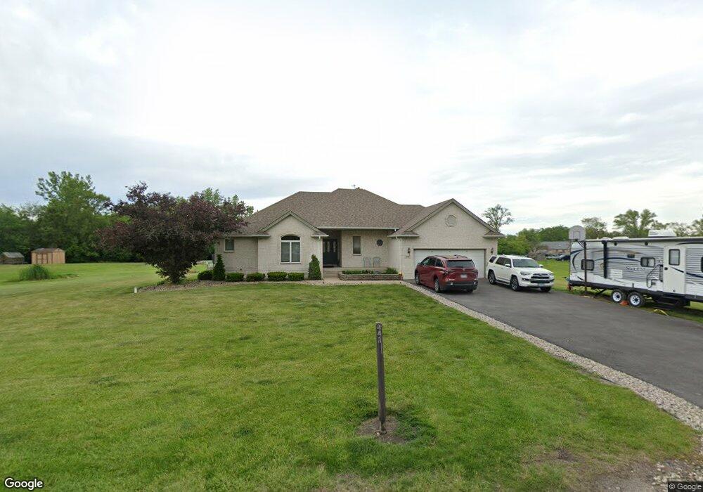
441 227th St Steger, IL 60475
West Steger NeighborhoodEstimated Value: $306,264 - $361,000
3
Beds
3
Baths
1,760
Sq Ft
$189/Sq Ft
Est. Value
About This Home
This home is located at 441 227th St, Steger, IL 60475 and is currently estimated at $333,066, approximately $189 per square foot. 441 227th St is a home located in Cook County with nearby schools including Steger Primary Center, Steger Intermediate Center, and Columbia Central School.
Ownership History
Date
Name
Owned For
Owner Type
Purchase Details
Closed on
Dec 4, 2001
Sold by
Zych Donald C and Zych Debra L
Bought by
Moreno William and Moreno Areli
Current Estimated Value
Home Financials for this Owner
Home Financials are based on the most recent Mortgage that was taken out on this home.
Original Mortgage
$196,350
Outstanding Balance
$73,997
Interest Rate
6.53%
Estimated Equity
$259,069
Create a Home Valuation Report for This Property
The Home Valuation Report is an in-depth analysis detailing your home's value as well as a comparison with similar homes in the area
Home Values in the Area
Average Home Value in this Area
Purchase History
| Date | Buyer | Sale Price | Title Company |
|---|---|---|---|
| Moreno William | $231,000 | -- |
Source: Public Records
Mortgage History
| Date | Status | Borrower | Loan Amount |
|---|---|---|---|
| Open | Moreno William | $196,350 |
Source: Public Records
Tax History
| Year | Tax Paid | Tax Assessment Tax Assessment Total Assessment is a certain percentage of the fair market value that is determined by local assessors to be the total taxable value of land and additions on the property. | Land | Improvement |
|---|---|---|---|---|
| 2025 | $6,297 | $22,212 | $6,122 | $16,090 |
| 2024 | $6,297 | $22,212 | $6,122 | $16,090 |
| 2023 | $4,451 | $22,212 | $6,122 | $16,090 |
| 2022 | $4,451 | $14,353 | $4,082 | $10,271 |
| 2021 | $4,203 | $14,351 | $4,081 | $10,270 |
| 2020 | $4,214 | $14,351 | $4,081 | $10,270 |
| 2019 | $4,501 | $15,759 | $3,061 | $12,698 |
| 2018 | $4,350 | $15,759 | $3,061 | $12,698 |
| 2017 | $4,429 | $15,759 | $3,061 | $12,698 |
| 2016 | $4,698 | $15,219 | $2,040 | $13,179 |
| 2015 | $4,632 | $15,219 | $2,040 | $13,179 |
| 2014 | $4,646 | $15,219 | $2,040 | $13,179 |
| 2013 | $3,697 | $13,636 | $2,040 | $11,596 |
Source: Public Records
Map
Nearby Homes
- 22939 Sherman Rd
- 71 227th Place
- 23000 Sherman Rd
- 304 Royal Oak Dr
- 71 Hereford Dr
- 3479 Innsbruck Ln
- 7 Debra Ct
- 3449 Somerset St
- 20 Geneva Ct
- 274 E 34th St
- 205 Hereford Ave
- 129 Cornwall Dr
- 3433 Huntley Terrace
- 883 Honey Ln
- 917 Patricia Ln Unit 89058
- 3412 Donovan Dr Unit 1
- 212 Durham Dr
- 3041 Hopkins St
- 621 Huntley Terrace
- 550 Belfast Terrace
- 22650 Sherman Rd
- 22711 Lahon Rd
- 435 227th St
- 22600 Sherman Rd
- 22700 Sherman Rd
- 22564 Sherman Rd
- 22727 Lahon Rd
- 22710 Sherman Rd
- 22720 Lahon Rd
- 22700 Lahon Rd
- 22568 Sherman Rd
- 22568 Sherman Rd
- 22720 Sherman Rd
- 22562 Sherman Rd
- 22649 Sherman Rd
- 22730 Sherman Rd
- 22731 Lahon Rd
- 22679 Frederick Rd
- 22663 Frederick Rd
- 22560 Sherman Rd
Your Personal Tour Guide
Ask me questions while you tour the home.