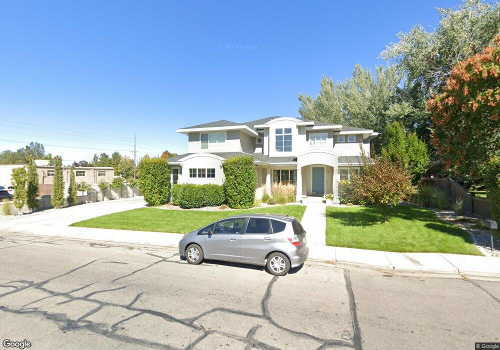
441 E 2950 N Unit 2 Provo, UT 84604
Rock Canyon NeighborhoodEstimated Value: $1,174,000 - $1,343,000
4
Beds
3
Baths
3,450
Sq Ft
$359/Sq Ft
Est. Value
About This Home
This home is located at 441 E 2950 N Unit 2, Provo, UT 84604 and is currently estimated at $1,238,739, approximately $359 per square foot. 441 E 2950 N Unit 2 is a home located in Utah County with nearby schools including Rock Canyon Elementary School, Centennial Middle School, and Timpview High School.
Ownership History
Date
Name
Owned For
Owner Type
Purchase Details
Closed on
Nov 23, 2020
Sold by
Shakespcare Jill
Bought by
Shakespcare William A and Shakespcare Jill S
Current Estimated Value
Purchase Details
Closed on
Nov 7, 2016
Sold by
Bunker Darin K
Bought by
Bunker Darin K and Bunker Chellese
Home Financials for this Owner
Home Financials are based on the most recent Mortgage that was taken out on this home.
Original Mortgage
$497,500
Interest Rate
3.5%
Mortgage Type
Adjustable Rate Mortgage/ARM
Purchase Details
Closed on
Oct 17, 2013
Sold by
Bushnell Jonathan and Oneill Anu K
Bought by
Bunker Darin K
Home Financials for this Owner
Home Financials are based on the most recent Mortgage that was taken out on this home.
Original Mortgage
$481,500
Interest Rate
4.55%
Mortgage Type
Construction
Purchase Details
Closed on
Feb 19, 2013
Sold by
Paka Llc
Bought by
Bushnell Jonathan and Oneill Anu K
Home Financials for this Owner
Home Financials are based on the most recent Mortgage that was taken out on this home.
Original Mortgage
$83,700
Interest Rate
3.36%
Mortgage Type
New Conventional
Create a Home Valuation Report for This Property
The Home Valuation Report is an in-depth analysis detailing your home's value as well as a comparison with similar homes in the area
Home Values in the Area
Average Home Value in this Area
Purchase History
| Date | Buyer | Sale Price | Title Company |
|---|---|---|---|
| Shakespcare William A | -- | Accommodation | |
| Shakespcare Jill | -- | Backman Orem | |
| Bunker Darin K | -- | None Available | |
| Bunker Darin K | -- | First American Title Co Llc | |
| Bushnell Jonathan | -- | Keystone Title Ins Agency |
Source: Public Records
Mortgage History
| Date | Status | Borrower | Loan Amount |
|---|---|---|---|
| Previous Owner | Bunker Darin K | $497,500 | |
| Previous Owner | Bunker Darin K | $481,500 | |
| Previous Owner | Bushnell Jonathan | $83,700 |
Source: Public Records
Tax History
| Year | Tax Paid | Tax Assessment Tax Assessment Total Assessment is a certain percentage of the fair market value that is determined by local assessors to be the total taxable value of land and additions on the property. | Land | Improvement |
|---|---|---|---|---|
| 2025 | $5,377 | $571,835 | -- | -- |
| 2024 | $5,377 | $529,265 | $0 | $0 |
| 2023 | $5,227 | $507,265 | $0 | $0 |
| 2022 | $5,623 | $550,220 | $0 | $0 |
| 2021 | $4,511 | $769,900 | $196,600 | $573,300 |
| 2020 | $4,537 | $725,900 | $163,800 | $562,100 |
| 2019 | $3,933 | $654,300 | $163,800 | $490,500 |
| 2018 | $3,426 | $578,100 | $151,600 | $426,500 |
| 2017 | $3,381 | $313,445 | $0 | $0 |
| 2016 | $3,288 | $284,130 | $0 | $0 |
| 2015 | $2,660 | $232,375 | $0 | $0 |
| 2014 | $963 | $87,700 | $0 | $0 |
Source: Public Records
Map
Nearby Homes
- 2774 N 370 E
- 3025 N 250 E
- 758 E 3030 N
- 3043 Bannock Dr
- 5600 N Canyon Rd
- 2735 N Country Club Dr
- 788 E 2680 N
- 3013 N 100 W
- 3057 N 100 W
- 3129 Cherokee Ln
- 3221 Shadowbrook Cir
- 3305 N Shadowbrook Cir
- 2999 N Marrcrest West Dr
- 2939 N Marrcrest Dr W
- 111 Candlewood Place
- 3240 Shadowbrook Dr
- 3250 Mohawk Ln
- 3711 N Canyon Rd
- 158 Woodside Dr
- 240 E 2230 N Unit 7
Your Personal Tour Guide
Ask me questions while you tour the home.