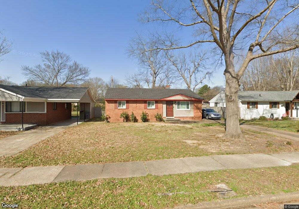
441 Malboro Rd Memphis, TN 38120
East Memphis NeighborhoodEstimated Value: $157,000 - $203,000
3
Beds
1
Bath
1,025
Sq Ft
$173/Sq Ft
Est. Value
About This Home
This home is located at 441 Malboro Rd, Memphis, TN 38120 and is currently estimated at $177,789, approximately $173 per square foot. 441 Malboro Rd is a home located in Shelby County with nearby schools including Richland Elementary School, White Station Middle, and White Station High.
Ownership History
Date
Name
Owned For
Owner Type
Purchase Details
Closed on
Nov 4, 2021
Sold by
Phifer Joyce Ann and Freeman Danny R
Bought by
Phifer Joyce Ann and Freeman Danny R
Current Estimated Value
Purchase Details
Closed on
Sep 29, 2011
Sold by
Phifer Joyce Ann
Bought by
Phifer Joyce Ann and Freeman Danny R
Home Financials for this Owner
Home Financials are based on the most recent Mortgage that was taken out on this home.
Original Mortgage
$58,500
Interest Rate
4.3%
Mortgage Type
New Conventional
Create a Home Valuation Report for This Property
The Home Valuation Report is an in-depth analysis detailing your home's value as well as a comparison with similar homes in the area
Home Values in the Area
Average Home Value in this Area
Purchase History
| Date | Buyer | Sale Price | Title Company |
|---|---|---|---|
| Phifer Joyce Ann | -- | Realty Title | |
| Phifer Joyce Ann | -- | Baymark Title & Escrow Servi |
Source: Public Records
Mortgage History
| Date | Status | Borrower | Loan Amount |
|---|---|---|---|
| Previous Owner | Phifer Joyce Ann | $58,500 |
Source: Public Records
Tax History
| Year | Tax Paid | Tax Assessment Tax Assessment Total Assessment is a certain percentage of the fair market value that is determined by local assessors to be the total taxable value of land and additions on the property. | Land | Improvement |
|---|---|---|---|---|
| 2025 | $1,040 | $35,325 | $10,000 | $25,325 |
| 2024 | $1,040 | $30,675 | $5,900 | $24,775 |
| 2023 | $1,869 | $30,675 | $5,900 | $24,775 |
| 2022 | $1,869 | $30,675 | $5,900 | $24,775 |
| 2021 | $1,891 | $30,675 | $5,900 | $24,775 |
| 2020 | $1,453 | $20,050 | $4,800 | $15,250 |
| 2019 | $1,453 | $20,050 | $4,800 | $15,250 |
| 2018 | $1,453 | $20,050 | $4,800 | $15,250 |
| 2017 | $824 | $20,050 | $4,800 | $15,250 |
| 2016 | $804 | $18,400 | $0 | $0 |
| 2014 | $804 | $18,400 | $0 | $0 |
Source: Public Records
Map
Nearby Homes
- 506 Mcdermitt Rd
- 517 Malboro Rd
- 5524 Fountain Bay Dr
- 524 Mineral Rd
- 438 Mcelroy Rd
- 5382 Bentley Place
- 536 Wheaton Park Cove N
- 5364 Wheaton Park Ct
- 377 Fountain Lake Dr
- 379 Mcelroy Rd
- 5557 Mason Rd
- 5572 Mason Rd
- 407 Meadvale Rd
- 416 Rosser Rd
- 446 Rosser Rd
- 5313 Chickasaw Rd
- 5312 Brenton Ave
- 5219 Sequoia Rd
- 296 N White Station Rd
- 5347 Denwood Ave
- 435 Malboro Rd
- 447 Malboro Rd
- 427 Malboro Rd
- 453 Malboro Rd
- 442 Mcdermitt Rd
- 436 Mcdermitt Rd
- 448 Mcdermitt Rd
- 428 Mcdermitt Rd
- 438 Malboro Rd
- 454 Mcdermitt Rd
- 444 Malboro Rd
- 421 Malboro Rd
- 459 Malboro Rd
- 450 Malboro Rd
- 460 Mcdermitt Rd
- 422 Mcdermitt Rd
- 456 Malboro Rd
- 415 Malboro Rd
- 465 Malboro Rd
- 462 Malboro Rd
Your Personal Tour Guide
Ask me questions while you tour the home.