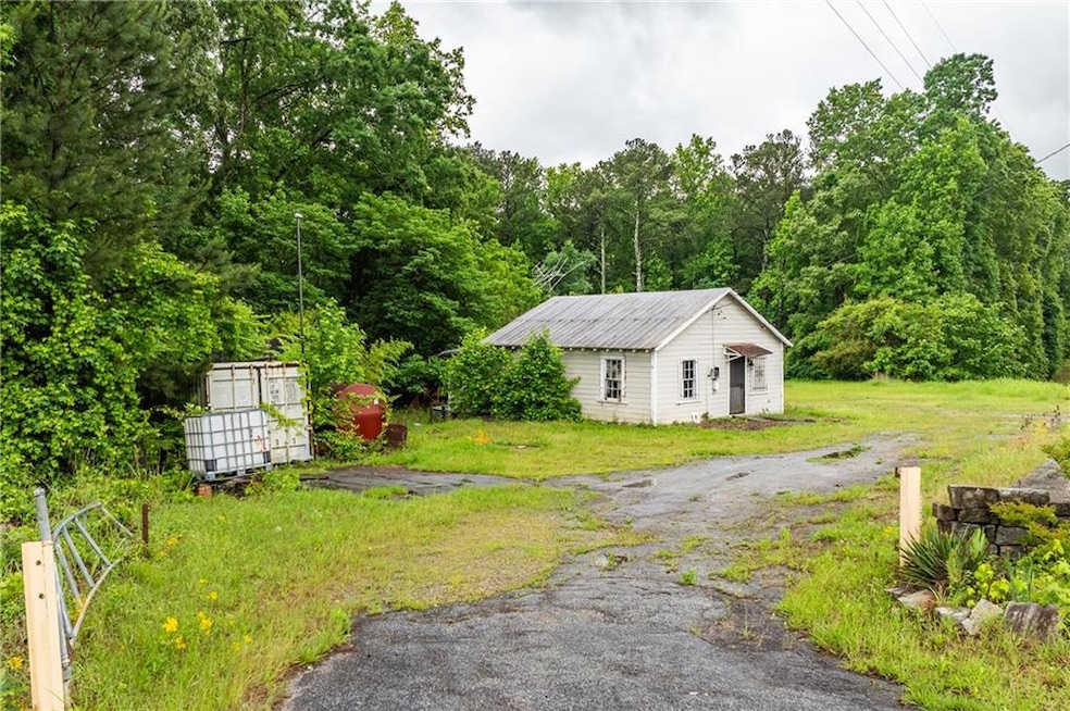
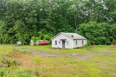
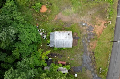
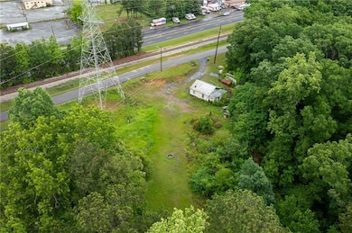
4410 Stacks Rd Atlanta, GA 30349
Estimated payment $4,778/month
Highlights
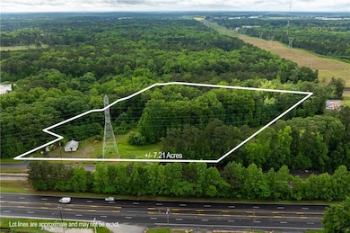
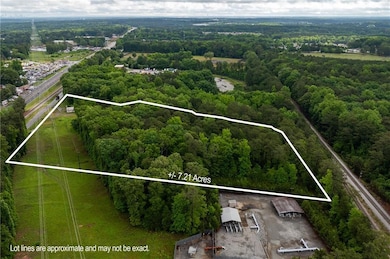
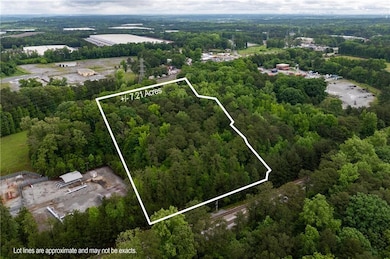
- 7.21 Acre Lot
- Ranch Style House
- No HOA
- Heavily Wooded Lot
About This Lot
This expansive 7+/- acre parcel of industrial land is available for sale in a prime location with good accessibility. Whether you're looking to expand your current operations or invest in a strategically located property, this land offers numerous possibilities for industrial development. The property is situated with close access to major highways, railways and transportation hubs. This land is well-suited for a range of industrial uses , including warehouses, distribution centers, manufacturing facilities, or other heavy industrial projects. Don't miss the opportunity to secure a large and versatile plot of industrial land. Contact us today to schedule a viewing and learn more about this existing investment opportunity.
Property Details
Property Type
- Land
Est. Annual Taxes
- $1,202
Year Built
- Built in 1939
Lot Details
- 7.21 Acre Lot
- Property fronts a county road
- Partial filled lot needs fill
- Heavily Wooded Lot
- Property is zoned M2, Industrial
Home Design
- Ranch Style House
- Fixer Upper
Bedrooms and Bathrooms
- 2 Main Level Bedrooms
- 1 Full Bathroom
Schools
- Feldwood Elementary School
- Mcnair - Fulton Middle School
- Banneker High School
Utilities
- Phone Available
- Cable TV Available
Community Details
- No Home Owners Association
Listing and Financial Details
- Assessor Parcel Number 09F260201080657
Map
Home Values in the Area
Average Home Value in this Area
Tax History
| Year | Tax Paid | Tax Assessment Tax Assessment Total Assessment is a certain percentage of the fair market value that is determined by local assessors to be the total taxable value of land and additions on the property. | Land | Improvement |
|---|---|---|---|---|
| 2025 | $1,202 | $49,120 | $24,360 | $24,760 |
| 2023 | $881 | $31,200 | $11,120 | $20,080 |
| 2022 | $1,223 | $31,200 | $11,120 | $20,080 |
| 2021 | $357 | $30,320 | $10,800 | $19,520 |
| 2020 | $356 | $29,960 | $10,680 | $19,280 |
| 2019 | $411 | $28,120 | $21,760 | $6,360 |
| 2018 | $370 | $22,480 | $17,440 | $5,040 |
| 2017 | $378 | $22,080 | $15,520 | $6,560 |
| 2016 | $377 | $22,080 | $15,520 | $6,560 |
| 2015 | $378 | $22,080 | $15,520 | $6,560 |
| 2014 | $379 | $22,080 | $15,520 | $6,560 |
Property History
| Date | Event | Price | List to Sale | Price per Sq Ft |
|---|---|---|---|---|
| 10/31/2025 10/31/25 | For Sale | $899,900 | -- | -- |
Purchase History
| Date | Type | Sale Price | Title Company |
|---|---|---|---|
| Warranty Deed | -- | -- | |
| Quit Claim Deed | -- | -- | |
| Deed | $205,000 | -- | |
| Deed | $150,000 | -- | |
| Deed | $15,000 | -- |
Mortgage History
| Date | Status | Loan Amount | Loan Type |
|---|---|---|---|
| Previous Owner | $25,000 | Stand Alone Refi Refinance Of Original Loan |
Source: First Multiple Listing Service (FMLS)
MLS Number: 7677671
APN: 09F-2602-0108-065-7
![]() Listings identified with the FMLS IDX logo come from FMLS and are held by brokerage firms other than the owner of this website. The listing brokerage is identified in any listing details. Information is deemed reliable but is not guaranteed. If you believe any FMLS listing contains material that infringes your copyrighted work please visit www.fmls.com/dmca to review our DMCA policy and learn how to submit a takedown request. © 2026 First Multiple Listing Service, Inc.
Listings identified with the FMLS IDX logo come from FMLS and are held by brokerage firms other than the owner of this website. The listing brokerage is identified in any listing details. Information is deemed reliable but is not guaranteed. If you believe any FMLS listing contains material that infringes your copyrighted work please visit www.fmls.com/dmca to review our DMCA policy and learn how to submit a takedown request. © 2026 First Multiple Listing Service, Inc.
Disclaimer: Certain information contained herein is derived from information provided by parties other than Homes.com. All information provided is deemed reliable, but is not guaranteed to be accurate and should be independently verified.
- 4230 Winston Cir
- 5565 Mason Rd Unit REAR
- 4160 Alveston Dr
- 4898 Wexford Trail
- 4836 Station Ln
- 4840 Station Ln
- 4828 Station Ln
- 4925 Sierra Way
- 4944 Wexford Trail
- 5615 Wisbech Way
- 3841 Makeover Ct
- 4140 Pierce Rd
- 4030 Melanie Woods Dr
- 4350 Melanie Dr Unit 3
- 135 Melanie Ct
- 120 Melanie Ct
- 820 Tallulah Ct
- Cecil Plan at The Enclave at Stonewall Station
- Nelson Plan at The Enclave at Stonewall Station
- 515 Rock Lake View
- 4234 Winston Cir
- 215 Marriott Dr
- 5856 Cooks Rd
- 5505 Sierra Tr
- 610 Leitrim Way
- 5575 Oglesby Rd
- 5100 Welcome All Rd SW
- 4100 Pierce Rd
- 813 Blue Hill Ln
- 3314 Stonewall Ln
- 5100 Highpoint Rd
- 6294 Mallory Ridge
- 4316 Mallory Ct
- 5565 Hillcrest Dr
- 4701 Flat Shoals Rd Unit 37H
- 3900 Shandra Way
- 4701 Flat Shoals Rd
- 6300 Oakley Rd
- 4300 Flat Shoals Rd
- 3810 Springside Ln
