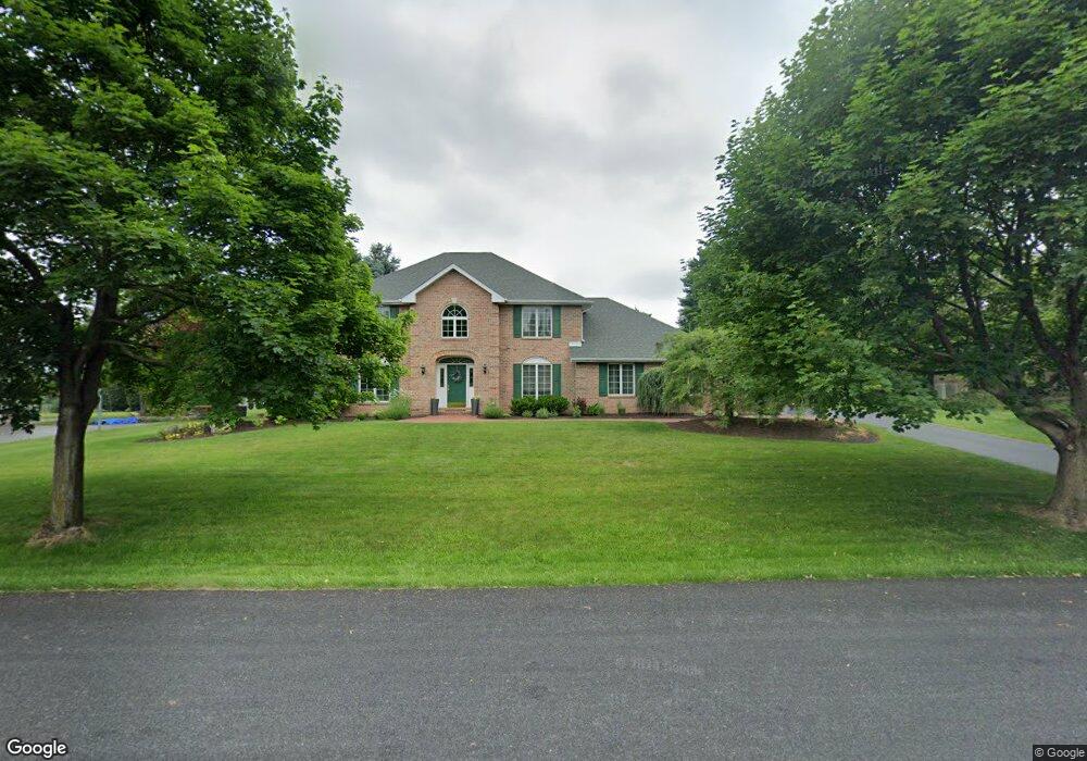
4413 Newton Cir Emmaus, PA 18049
Lower Macungie Township East NeighborhoodEstimated Value: $528,000 - $659,000
4
Beds
3
Baths
2,404
Sq Ft
$244/Sq Ft
Est. Value
About This Home
This home is located at 4413 Newton Cir, Emmaus, PA 18049 and is currently estimated at $586,963, approximately $244 per square foot. 4413 Newton Cir is a home located in Lehigh County with nearby schools including Macungie Elementary School, Eyer Middle School, and Emmaus High School.
Ownership History
Date
Name
Owned For
Owner Type
Purchase Details
Closed on
Mar 12, 2021
Sold by
Diaz Nelson A and Diaz Silvia M
Bought by
Diaz Philip M and Diaz Shannon N
Current Estimated Value
Home Financials for this Owner
Home Financials are based on the most recent Mortgage that was taken out on this home.
Original Mortgage
$320,000
Outstanding Balance
$286,857
Interest Rate
2.7%
Mortgage Type
New Conventional
Estimated Equity
$300,106
Purchase Details
Closed on
Jul 17, 1992
Sold by
Brookhaven Development Corp
Bought by
Diaz Nelson A and Diaz Silvia M
Purchase Details
Closed on
Dec 31, 1985
Bought by
Brookhaven Development Corp
Create a Home Valuation Report for This Property
The Home Valuation Report is an in-depth analysis detailing your home's value as well as a comparison with similar homes in the area
Home Values in the Area
Average Home Value in this Area
Purchase History
| Date | Buyer | Sale Price | Title Company |
|---|---|---|---|
| Diaz Philip M | $400,000 | None Available | |
| Diaz Nelson A | $66,900 | -- | |
| Brookhaven Development Corp | $354,900 | -- |
Source: Public Records
Mortgage History
| Date | Status | Borrower | Loan Amount |
|---|---|---|---|
| Open | Diaz Philip M | $320,000 |
Source: Public Records
Tax History Compared to Growth
Tax History
| Year | Tax Paid | Tax Assessment Tax Assessment Total Assessment is a certain percentage of the fair market value that is determined by local assessors to be the total taxable value of land and additions on the property. | Land | Improvement |
|---|---|---|---|---|
| 2025 | $8,136 | $318,700 | $50,600 | $268,100 |
| 2024 | $7,872 | $318,700 | $50,600 | $268,100 |
| 2023 | $7,715 | $318,700 | $50,600 | $268,100 |
| 2022 | $7,532 | $318,700 | $268,100 | $50,600 |
| 2021 | $7,372 | $318,700 | $50,600 | $268,100 |
| 2020 | $7,302 | $318,700 | $50,600 | $268,100 |
| 2019 | $7,177 | $318,700 | $50,600 | $268,100 |
| 2018 | $7,083 | $318,700 | $50,600 | $268,100 |
| 2017 | $6,959 | $318,700 | $50,600 | $268,100 |
| 2016 | -- | $318,700 | $50,600 | $268,100 |
| 2015 | -- | $318,700 | $50,600 | $268,100 |
| 2014 | -- | $318,700 | $50,600 | $268,100 |
Source: Public Records
Map
Nearby Homes
- 4490 Canterbury Dr
- 3149 Sheffield Dr
- 3186 Overlook Dr
- 3045 Sheffield Dr
- 3623 Daylily Dr
- 3703 Samantha Ln Unit Lot 70
- 3736 Samantha Ln Unit Lot 7
- 3748 Samantha Ln
- 3748 Samantha Ln Unit Lot 3
- 3734 Samantha Ln Unit Lot 8
- 3746 Samantha Ln Unit Lot 4
- 3713 Samantha Ln Unit Lot 73
- 3707 Samantha Ln Unit Lot 71
- 3810 Allen St
- Foxgrove I - TR Plan at The Fields at Twin Run
- Folcroft -TR Plan at The Fields at Twin Run
- Sierra - TR Plan at The Fields at Twin Run
- Cheswick - TR Plan at The Fields at Twin Run
- 3754 Samantha Ln
- Penrose I - TR Plan at The Fields at Twin Run
- 4403 Newton Cir
- 4423 Newton Cir
- 3290 Gristmill Dr
- 3308 Gristmill Dr
- 3308 Gristmill Dr Unit M9
- 4422 Newton Cir
- 3272 Gristmill Dr
- 0 Gristmill Dr
- 3326 Gristmill Dr
- 4412 Newton Cir
- 4433 Newton Cir
- 4391 Newton Cir
- 4454 Newton Cir
- 3273 Gristmill Dr Unit M22
- 3254 Gristmill Dr
- 3297 Gristmill Dr
- 3344 Gristmill Dr
- 3249 Gristmill Dr
- 4404 Newton Cir
- 4467 Newton Cir