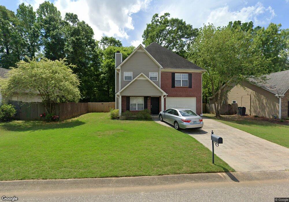
442 Cedar Grove Ln Maylene, AL 35114
Estimated Value: $261,000 - $356,000
--
Bed
2
Baths
2,304
Sq Ft
$135/Sq Ft
Est. Value
About This Home
This home is located at 442 Cedar Grove Ln, Maylene, AL 35114 and is currently estimated at $311,377, approximately $135 per square foot. 442 Cedar Grove Ln is a home located in Shelby County with nearby schools including Thompson Intermediate School, Thompson Middle School, and Thompson High School.
Ownership History
Date
Name
Owned For
Owner Type
Purchase Details
Closed on
Apr 3, 2002
Sold by
Graham Denise L and Graham Wiliam Blake
Bought by
Graham Denise L and Graham William Blake
Current Estimated Value
Purchase Details
Closed on
Apr 27, 1999
Sold by
Tom Lacey Construction Co Inc
Bought by
Smothers Denise L
Home Financials for this Owner
Home Financials are based on the most recent Mortgage that was taken out on this home.
Original Mortgage
$115,000
Outstanding Balance
$29,615
Interest Rate
7%
Estimated Equity
$281,762
Create a Home Valuation Report for This Property
The Home Valuation Report is an in-depth analysis detailing your home's value as well as a comparison with similar homes in the area
Home Values in the Area
Average Home Value in this Area
Purchase History
| Date | Buyer | Sale Price | Title Company |
|---|---|---|---|
| Graham Denise L | $500 | Stewart Title Insurance Co | |
| Smothers Denise L | $127,800 | Cahaba Title Inc |
Source: Public Records
Mortgage History
| Date | Status | Borrower | Loan Amount |
|---|---|---|---|
| Open | Smothers Denise L | $115,000 |
Source: Public Records
Tax History Compared to Growth
Tax History
| Year | Tax Paid | Tax Assessment Tax Assessment Total Assessment is a certain percentage of the fair market value that is determined by local assessors to be the total taxable value of land and additions on the property. | Land | Improvement |
|---|---|---|---|---|
| 2024 | $1,483 | $27,460 | $0 | $0 |
| 2023 | $1,373 | $26,180 | $0 | $0 |
| 2022 | $1,237 | $23,660 | $0 | $0 |
| 2021 | $1,101 | $21,140 | $0 | $0 |
| 2020 | $1,000 | $19,280 | $0 | $0 |
| 2019 | $962 | $18,580 | $0 | $0 |
| 2017 | $889 | $17,220 | $0 | $0 |
| 2015 | $838 | $16,280 | $0 | $0 |
| 2014 | $838 | $16,280 | $0 | $0 |
Source: Public Records
Map
Nearby Homes
- 155 Victoria Station
- 501 Ramsgate Dr
- 236 Queens Gate
- 208 Queens Gate
- 549 Ramsgate Dr
- 545 Ramsgate Dr
- 306 Mayfair Cir
- 217 Mayfair Park
- 309 Cedar Grove Ct
- 537 Ramsgate Dr
- 128 Oak St
- 233 Norwick Forest Dr
- 104 Maple St
- 109 Kingsley Cir
- 220 Cedar Meadow
- 280 Cedar Grove Pkwy
- 256 Cedar Meadow
- 217 Kensington Ln
- 1315 Yellowleaf Cir
- 112 Kingsley Ct
- 446 Cedar Grove Ln
- 436 Cedar Grove Ln
- 00 Cedar Grove Ln
- 450 Cedar Grove Ln
- 443 Cedar Grove Ln
- 432 Cedar Grove Ln
- 439 Cedar Grove Ln
- 447 Cedar Grove Ln
- 421 Cedar Grove Ln
- 454 Cedar Grove Ln
- 451 Cedar Grove Ln
- 417 Cedar Grove Ln
- 510 Cedar Grove Cir
- 506 Cedar Grove Cir
- 458 Cedar Grove Ln
- 514 Cedar Grove Cir
- 459 Cedar Grove Ln
- 428 Cedar Grove Ln
- 520 Cedar Grove Cir
- 502 Cedar Grove Cir