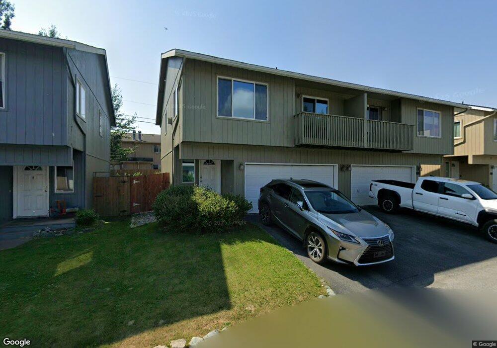
442 Ocean Point Dr Unit 20 Anchorage, AK 99515
Old Seward-Oceanview NeighborhoodEstimated Value: $335,000 - $347,984
3
Beds
2
Baths
1,376
Sq Ft
$248/Sq Ft
Est. Value
About This Home
This home is located at 442 Ocean Point Dr Unit 20, Anchorage, AK 99515 and is currently estimated at $341,492, approximately $248 per square foot. 442 Ocean Point Dr Unit 20 is a home located in Anchorage Municipality with nearby schools including Ocean View Elementary School, Hanshew Middle School, and Service High School.
Ownership History
Date
Name
Owned For
Owner Type
Purchase Details
Closed on
Jan 6, 2005
Sold by
Greek Neale Rosemary
Bought by
Kan Ming K
Current Estimated Value
Home Financials for this Owner
Home Financials are based on the most recent Mortgage that was taken out on this home.
Original Mortgage
$163,400
Outstanding Balance
$81,107
Interest Rate
5.7%
Mortgage Type
Purchase Money Mortgage
Estimated Equity
$260,385
Create a Home Valuation Report for This Property
The Home Valuation Report is an in-depth analysis detailing your home's value as well as a comparison with similar homes in the area
Home Values in the Area
Average Home Value in this Area
Purchase History
| Date | Buyer | Sale Price | Title Company |
|---|---|---|---|
| Kan Ming K | -- | First American Title Of Alas |
Source: Public Records
Mortgage History
| Date | Status | Borrower | Loan Amount |
|---|---|---|---|
| Open | Kan Ming K | $163,400 |
Source: Public Records
Tax History Compared to Growth
Tax History
| Year | Tax Paid | Tax Assessment Tax Assessment Total Assessment is a certain percentage of the fair market value that is determined by local assessors to be the total taxable value of land and additions on the property. | Land | Improvement |
|---|---|---|---|---|
| 2025 | $4,550 | $303,900 | -- | $303,900 |
| 2024 | $4,550 | $281,800 | $0 | $281,800 |
| 2023 | $4,592 | $254,800 | $0 | $254,800 |
| 2022 | $4,064 | $241,300 | $0 | $241,300 |
| 2021 | $4,166 | $231,200 | $0 | $231,200 |
| 2020 | $3,822 | $224,800 | $0 | $224,800 |
| 2019 | $3,712 | $226,900 | $0 | $226,900 |
| 2018 | $3,662 | $223,300 | $0 | $223,300 |
| 2017 | $3,583 | $228,800 | $0 | $228,800 |
| 2016 | $3,304 | $221,900 | $0 | $221,900 |
| 2015 | $3,304 | $214,600 | $0 | $214,600 |
| 2014 | $3,304 | $206,400 | $0 | $206,400 |
Source: Public Records
Map
Nearby Homes
- 12023 Whitecap Place Unit 37
- 12106 Lucille Ln Unit 1
- 271 Dailey Ave Unit 12
- 12120 Johns Rd
- 12301 Johns Rd Unit 6
- 411 Mariner Dr
- 200 W 123rd Ave
- 250 Botanical Cir
- 321 Ellen Cir
- 9031 Old Seward Hwy
- 11759 Birch Knoll Loop Unit 11759
- 1105 E Klatt Rd
- 12961 Nora Dr
- 12130 Timberlane Dr
- 1100 E 112th Ave Unit 2
- 840 Allison Cir
- 900 Botanical Heights Cir
- 11483 Moonrise Ridge Place Unit 10
- 1677 Circlewood Dr
- L8 B8 Spartan Dr
- 440 Ocean Point Dr Unit 19
- 460 Ocean Point Dr Unit 21
- 462 Ocean Point Dr Unit 22
- 422 Ocean Point Dr Unit 18
- 439 Ocean Point Dr Unit 72
- 441 Ocean Point Dr Unit 71
- 420 Ocean Point Dr Unit 17
- 459 Ocean Point Dr Unit 70
- 461 Ocean Point Dr Unit 69
- 461 Ocean Point Dr Unit 1376
- 480 Ocean Point Unit 23
- 480 Ocean Point
- 480 Ocean Point Dr Unit 23
- 12015 Tidepool Place Unit 52
- 12017 Tidepool Place Unit 51
- 12025 Tidepool Place Unit 50
- 12011 Whitecap Place Unit 40
- 12013 Whitecap Place Unit 39
- 12021 Whitecap Place Unit 38
- 12015 Coral Reef Place Unit 76