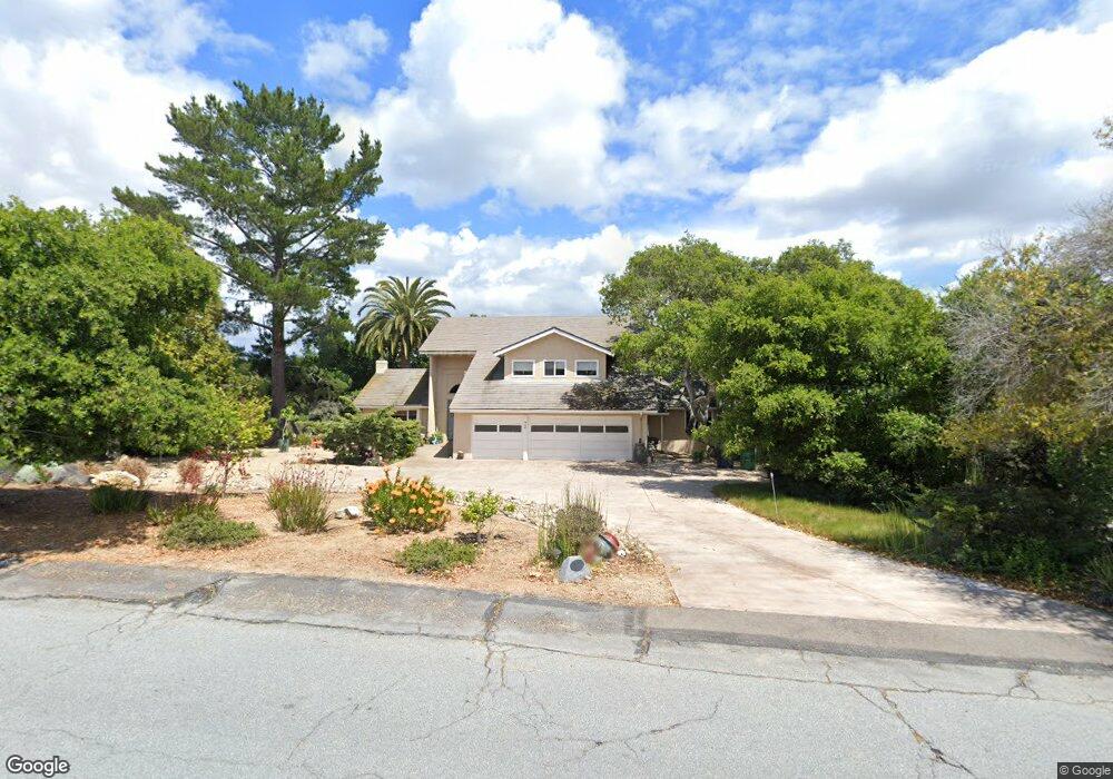
442 Saint Andrews Way Lompoc, CA 93436
Estimated Value: $990,964 - $1,206,000
5
Beds
3
Baths
3,063
Sq Ft
$357/Sq Ft
Est. Value
About This Home
This home is located at 442 Saint Andrews Way, Lompoc, CA 93436 and is currently estimated at $1,094,991, approximately $357 per square foot. 442 Saint Andrews Way is a home located in Santa Barbara County with nearby schools including Buena Vista Elementary School, Cabrillo High School, and Olive Grove Charter - Lompoc.
Ownership History
Date
Name
Owned For
Owner Type
Purchase Details
Closed on
Aug 22, 2013
Sold by
Hardy Denis M and Hardy Marilyn S
Bought by
Hardy Denis M and Hardy Marilyn S
Current Estimated Value
Purchase Details
Closed on
Apr 27, 1998
Sold by
Trubschenck Lorin N and Trubschenck Tr 6-13
Bought by
Hardy Denis M and Hardy Marilyn S
Home Financials for this Owner
Home Financials are based on the most recent Mortgage that was taken out on this home.
Original Mortgage
$170,000
Interest Rate
6.77%
Create a Home Valuation Report for This Property
The Home Valuation Report is an in-depth analysis detailing your home's value as well as a comparison with similar homes in the area
Home Values in the Area
Average Home Value in this Area
Purchase History
| Date | Buyer | Sale Price | Title Company |
|---|---|---|---|
| Hardy Denis M | -- | None Available | |
| Hardy Denis M | $275,000 | First American Title |
Source: Public Records
Mortgage History
| Date | Status | Borrower | Loan Amount |
|---|---|---|---|
| Closed | Hardy Denis M | $170,000 |
Source: Public Records
Tax History Compared to Growth
Tax History
| Year | Tax Paid | Tax Assessment Tax Assessment Total Assessment is a certain percentage of the fair market value that is determined by local assessors to be the total taxable value of land and additions on the property. | Land | Improvement |
|---|---|---|---|---|
| 2025 | $5,236 | $458,673 | $199,584 | $259,089 |
| 2023 | $5,236 | $440,864 | $191,835 | $249,029 |
| 2022 | $5,152 | $432,221 | $188,074 | $244,147 |
| 2021 | $5,206 | $423,747 | $184,387 | $239,360 |
| 2020 | $5,153 | $419,403 | $182,497 | $236,906 |
| 2019 | $5,075 | $411,180 | $178,919 | $232,261 |
| 2018 | $5,001 | $403,118 | $175,411 | $227,707 |
| 2017 | $4,825 | $395,215 | $171,972 | $223,243 |
| 2016 | $4,471 | $387,466 | $168,600 | $218,866 |
| 2014 | $4,373 | $374,172 | $162,815 | $211,357 |
Source: Public Records
Map
Nearby Homes
- 369 Falcon Crest Dr
- 4131 Oakwood Rd
- 579 Saint Andrews Way
- 3925 Clubhouse Ct
- 445 Firestone Way
- 4464 Greenbrier Rd
- 0 Oak Hill Dr Unit 24-783
- 317 Medinah Ln
- 3987 Agena Way
- 3986 Spica Way
- 210 Oak Hill Dr
- 220 Oak Hill Dr
- 4185 Vanguard Dr
- 189 Galaxy Way
- 196 Galaxy Way
- 4123 Constellation Rd
- 1445 Calle Marana
- 4533 Falcon Dr
- 244 Pegasus Ave
- 3951 Mesa Circle Dr
- 432 Saint Andrews Way
- 454 St Andrews Way
- 454 Saint Andrews Way
- 420 Saint Andrews Way
- 468 Saint Andrews Way
- 437 Saint Andrews Way
- 461 St Andrews Way
- 461 Saint Andrews Way
- 417 St Andrews Way
- 417 Saint Andrews Way
- 410 Saint Andrews Way
- 410 St Andrews Way
- 480 Saint Andrews Way
- 3989 Pinehurst Dr
- 485 Saint Andrews Way
- 494 St Andrews Way
- 401 Saint Andrews Way
- 494 Saint Andrews Way
- 460 Oak Hill Terrace
- 394 Saint Andrews Way