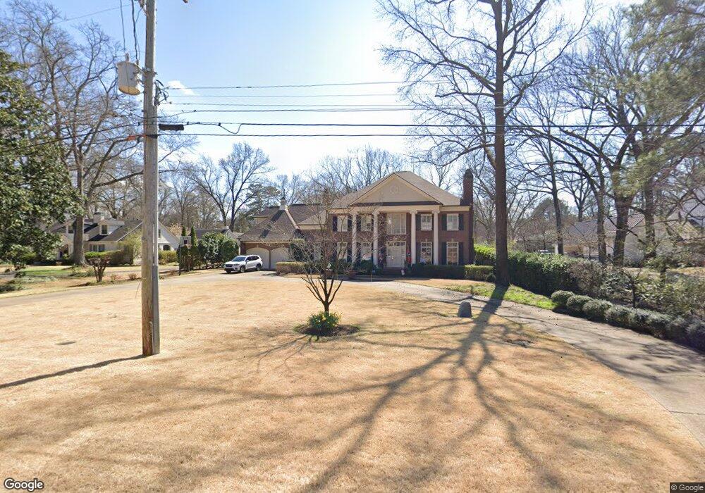
4425 Barfield Rd Memphis, TN 38117
East Memphis NeighborhoodEstimated Value: $1,057,345 - $1,116,000
5
Beds
4
Baths
5,397
Sq Ft
$201/Sq Ft
Est. Value
About This Home
This home is located at 4425 Barfield Rd, Memphis, TN 38117 and is currently estimated at $1,083,782, approximately $200 per square foot. 4425 Barfield Rd is a home located in Shelby County with nearby schools including White Station Elementary School, White Station High, and White Station Middle.
Ownership History
Date
Name
Owned For
Owner Type
Purchase Details
Closed on
Aug 29, 1997
Sold by
Gordon Devane D and Gordon Mary F
Bought by
Desantis Anthony M and Desantis Stephanie L
Current Estimated Value
Home Financials for this Owner
Home Financials are based on the most recent Mortgage that was taken out on this home.
Original Mortgage
$74,000
Outstanding Balance
$10,539
Interest Rate
7.43%
Estimated Equity
$1,073,243
Create a Home Valuation Report for This Property
The Home Valuation Report is an in-depth analysis detailing your home's value as well as a comparison with similar homes in the area
Home Values in the Area
Average Home Value in this Area
Purchase History
| Date | Buyer | Sale Price | Title Company |
|---|---|---|---|
| Desantis Anthony M | $198,000 | -- | |
| Desantis Anthony M | $198,000 | -- |
Source: Public Records
Mortgage History
| Date | Status | Borrower | Loan Amount |
|---|---|---|---|
| Open | Desantis Anthony M | $74,000 | |
| Closed | Desantis Anthony M | $74,000 |
Source: Public Records
Tax History
| Year | Tax Paid | Tax Assessment Tax Assessment Total Assessment is a certain percentage of the fair market value that is determined by local assessors to be the total taxable value of land and additions on the property. | Land | Improvement |
|---|---|---|---|---|
| 2025 | $6,751 | $263,750 | $59,450 | $204,300 |
| 2024 | $6,751 | $199,150 | $59,450 | $139,700 |
| 2023 | $12,132 | $199,150 | $59,450 | $139,700 |
| 2022 | $12,132 | $199,150 | $59,450 | $139,700 |
| 2021 | $12,274 | $199,150 | $59,450 | $139,700 |
| 2020 | $13,182 | $181,925 | $59,450 | $122,475 |
| 2019 | $13,182 | $181,925 | $59,450 | $122,475 |
| 2018 | $13,182 | $181,925 | $59,450 | $122,475 |
| 2017 | $7,477 | $181,925 | $59,450 | $122,475 |
| 2016 | $8,021 | $183,550 | $0 | $0 |
Source: Public Records
Map
Nearby Homes
- 150 Waring Rd
- 180 Waring Rd
- 4525 Barfield Rd
- 91 N Grove Park Rd
- 4303 Hathaway Ln
- 207 Gardenia Cove
- 4565 Normandy Rd
- 126 Wood Grove Rd
- 176 Belhaven St
- 4525 Sequoia Rd
- 4640 Chickasaw Rd
- 4321 Charleswood Ave
- 4130 Long Leaf Dr
- 4578 Sequoia Rd
- 194 Wallace Rd
- 441 Waring Rd
- 4151 Barfield Rd
- 4484 Charleswood Ave
- 4336 Hilldale Ave
- 140 S Grove Park Rd
- 4435 Barfield Rd
- 4411 Barfield Rd
- 4391 Barfield Rd
- 4418 Normandy Ave
- 4451 Barfield Rd
- 4436 Normandy Ave
- 4410 Normandy Ave
- 4426 Barfield Rd
- 4440 Barfield Rd
- 4410 Barfield Rd
- 4446 Normandy Ave
- 4394 Normandy Ave
- 4461 Barfield Rd
- 4446 Barfield Rd
- 4460 Normandy Ave
- 130 Waring Rd
- 4411 Normandy Ave
- 200 Waring Rd
- 4481 Barfield Rd
- 4401 Normandy Ave
Your Personal Tour Guide
Ask me questions while you tour the home.