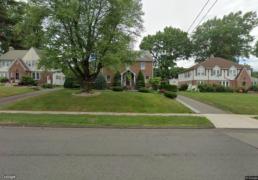
443 Ridge Rd Wethersfield, CT 06109
Estimated Value: $353,000 - $686,198
4
Beds
7
Baths
3,211
Sq Ft
$172/Sq Ft
Est. Value
About This Home
This home is located at 443 Ridge Rd, Wethersfield, CT 06109 and is currently estimated at $553,050, approximately $172 per square foot. 443 Ridge Rd is a home located in Hartford County with nearby schools including Emerson-Williams School, Silas Deane Middle School, and Wethersfield High School.
Ownership History
Date
Name
Owned For
Owner Type
Purchase Details
Closed on
Jan 31, 2008
Sold by
Deutsche Bank Natl T C
Bought by
Mozzicato Gina
Current Estimated Value
Purchase Details
Closed on
Nov 29, 2006
Sold by
Whitcomb T and Kilburn Faith F
Bought by
Drigpal Chandrawattie and Drigpal Drupattee S
Home Financials for this Owner
Home Financials are based on the most recent Mortgage that was taken out on this home.
Original Mortgage
$345,800
Interest Rate
8.85%
Create a Home Valuation Report for This Property
The Home Valuation Report is an in-depth analysis detailing your home's value as well as a comparison with similar homes in the area
Home Values in the Area
Average Home Value in this Area
Purchase History
| Date | Buyer | Sale Price | Title Company |
|---|---|---|---|
| Mozzicato Gina | $256,500 | -- | |
| Drigpal Chandrawattie | $364,000 | -- |
Source: Public Records
Mortgage History
| Date | Status | Borrower | Loan Amount |
|---|---|---|---|
| Open | Drigpal Chandrawattie | $150,000 | |
| Closed | Drigpal Chandrawattie | $150,000 | |
| Previous Owner | Drigpal Chandrawattie | $345,800 |
Source: Public Records
Tax History
| Year | Tax Paid | Tax Assessment Tax Assessment Total Assessment is a certain percentage of the fair market value that is determined by local assessors to be the total taxable value of land and additions on the property. | Land | Improvement |
|---|---|---|---|---|
| 2025 | $16,317 | $395,840 | $72,110 | $323,730 |
| 2024 | $11,308 | $261,640 | $64,400 | $197,240 |
| 2023 | $10,931 | $261,640 | $64,400 | $197,240 |
| 2022 | $10,748 | $261,640 | $64,400 | $197,240 |
| 2021 | $10,641 | $261,640 | $64,400 | $197,240 |
| 2020 | $10,646 | $261,640 | $64,400 | $197,240 |
| 2019 | $10,659 | $261,640 | $64,400 | $197,240 |
| 2018 | $10,966 | $268,900 | $64,300 | $204,600 |
| 2017 | $10,694 | $268,900 | $64,300 | $204,600 |
| 2016 | $10,363 | $268,900 | $64,300 | $204,600 |
| 2015 | $10,269 | $268,900 | $64,300 | $204,600 |
| 2014 | $9,879 | $268,900 | $64,300 | $204,600 |
Source: Public Records
Map
Nearby Homes
- 144 Brown St
- 295 Ridge Rd Unit 8
- 273 Forest Dr
- 173 Timber Trail
- 55 Rutledge Rd
- 20 Forest Dr
- 129 Goff Rd
- 63 Wells Farm Dr
- 1 Bristol St
- 19 Albert Ave
- 764 Ridge Rd
- 15 Potter Crossing
- 62 Schoolhouse Crossing
- 1 Brussels Ave
- 25 Tinsmith Crossing
- 192 Wolcott Hill Rd
- 158 Dix Rd
- 146 Dudley Rd
- 7 Barrington Dr Unit C
- 219-221 Jordan Ln
Your Personal Tour Guide
Ask me questions while you tour the home.