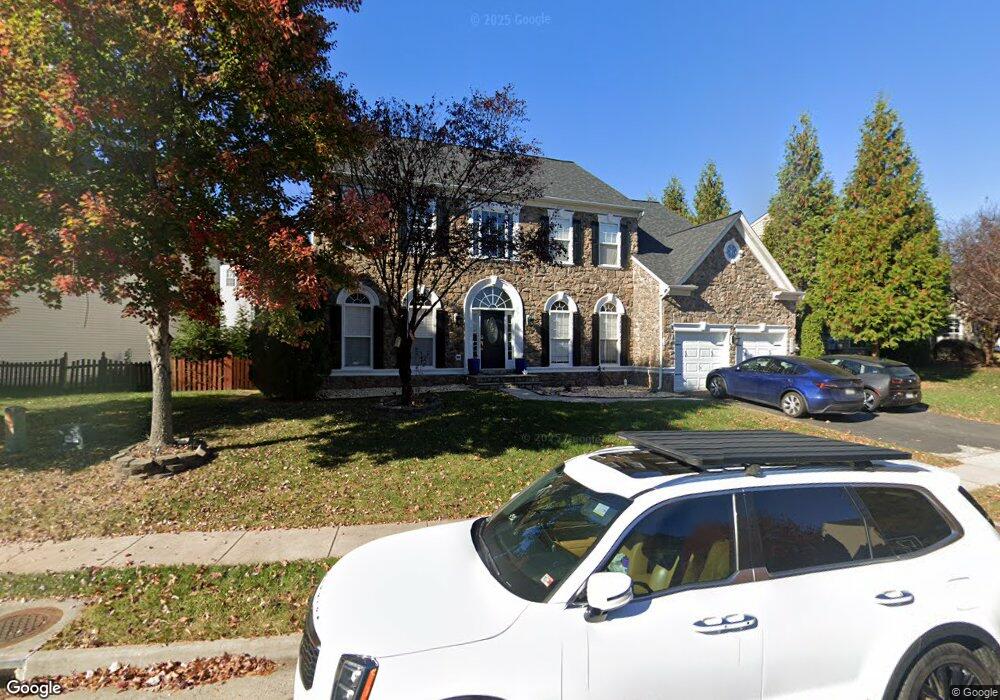
44359 Apache Cir Ashburn, VA 20147
Ashbrook NeighborhoodEstimated Value: $1,092,000 - $1,129,000
5
Beds
5
Baths
3,488
Sq Ft
$320/Sq Ft
Est. Value
About This Home
This home is located at 44359 Apache Cir, Ashburn, VA 20147 and is currently estimated at $1,114,786, approximately $319 per square foot. 44359 Apache Cir is a home located in Loudoun County with nearby schools including Ashburn Elementary School, Farmwell Station Middle School, and Broad Run High School.
Ownership History
Date
Name
Owned For
Owner Type
Purchase Details
Closed on
May 26, 2011
Sold by
Wallace Andrew
Bought by
Alaoui Karima
Current Estimated Value
Home Financials for this Owner
Home Financials are based on the most recent Mortgage that was taken out on this home.
Original Mortgage
$534,921
Outstanding Balance
$370,834
Interest Rate
4.75%
Mortgage Type
FHA
Estimated Equity
$743,952
Purchase Details
Closed on
Dec 15, 2005
Sold by
Richamond American Homes
Bought by
Wallace Andrew
Home Financials for this Owner
Home Financials are based on the most recent Mortgage that was taken out on this home.
Original Mortgage
$656,072
Interest Rate
6.34%
Mortgage Type
New Conventional
Create a Home Valuation Report for This Property
The Home Valuation Report is an in-depth analysis detailing your home's value as well as a comparison with similar homes in the area
Home Values in the Area
Average Home Value in this Area
Purchase History
| Date | Buyer | Sale Price | Title Company |
|---|---|---|---|
| Alaoui Karima | $557,500 | -- | |
| Wallace Andrew | $820,090 | -- |
Source: Public Records
Mortgage History
| Date | Status | Borrower | Loan Amount |
|---|---|---|---|
| Open | Alaoui Karima | $534,921 | |
| Previous Owner | Wallace Andrew | $656,072 |
Source: Public Records
Tax History Compared to Growth
Tax History
| Year | Tax Paid | Tax Assessment Tax Assessment Total Assessment is a certain percentage of the fair market value that is determined by local assessors to be the total taxable value of land and additions on the property. | Land | Improvement |
|---|---|---|---|---|
| 2025 | $8,718 | $1,083,040 | $299,400 | $783,640 |
| 2024 | $8,193 | $947,190 | $284,400 | $662,790 |
| 2023 | $7,755 | $886,240 | $284,400 | $601,840 |
| 2022 | $7,650 | $859,530 | $269,400 | $590,130 |
| 2021 | $7,189 | $733,530 | $239,400 | $494,130 |
| 2020 | $7,190 | $694,650 | $198,200 | $496,450 |
| 2019 | $7,057 | $675,280 | $198,200 | $477,080 |
| 2018 | $7,089 | $653,390 | $188,200 | $465,190 |
| 2017 | $7,018 | $623,850 | $188,200 | $435,650 |
| 2016 | $7,199 | $628,750 | $0 | $0 |
| 2015 | $6,867 | $416,790 | $0 | $416,790 |
| 2014 | $7,316 | $455,190 | $0 | $455,190 |
Source: Public Records
Map
Nearby Homes
- 20389 Oyster Reef Place
- 20328 Newfoundland Square
- 20364 Newfoundland Square
- 44501 Wolfhound Square
- 44614 Wolfhound Square
- 44531 Wolfhound Square
- 20432 Island West Square
- 20305 Savin Hill Dr
- 20379 Codman Dr
- 20432 Cool Fern Square
- 20254 Northpark Dr
- 20402 Cool Fern Square
- 44583 Strabane Terrace
- HOMESITE 52 Strabane Terrace
- HOMESITE 43 Strabane Terrace
- 44591 Strabane Terrace
- HOMESITE 49 Strabane Terrace
- 44581 Strabane Terrace
- 20183 Northpark Dr
- 44532 Stepney Dr
- 44367 Apache Cir
- 44355 Apache Cir
- 44328 Crow Ct
- 44324 Crow Ct
- 44358 Apache Cir
- 44362 Apache Cir
- 44375 Apache Cir
- 44354 Apache Cir
- 44347 Apache Cir
- 44366 Apache Cir
- 44350 Apache Cir
- 44325 Crow Ct
- 44320 Crow Ct
- 44370 Apache Cir
- 44339 Apache Cir
- 44383 Apache Cir
- 44346 Apache Cir
- 44340 Navajo Dr
- 44344 Navajo Dr
- 44336 Navajo Dr