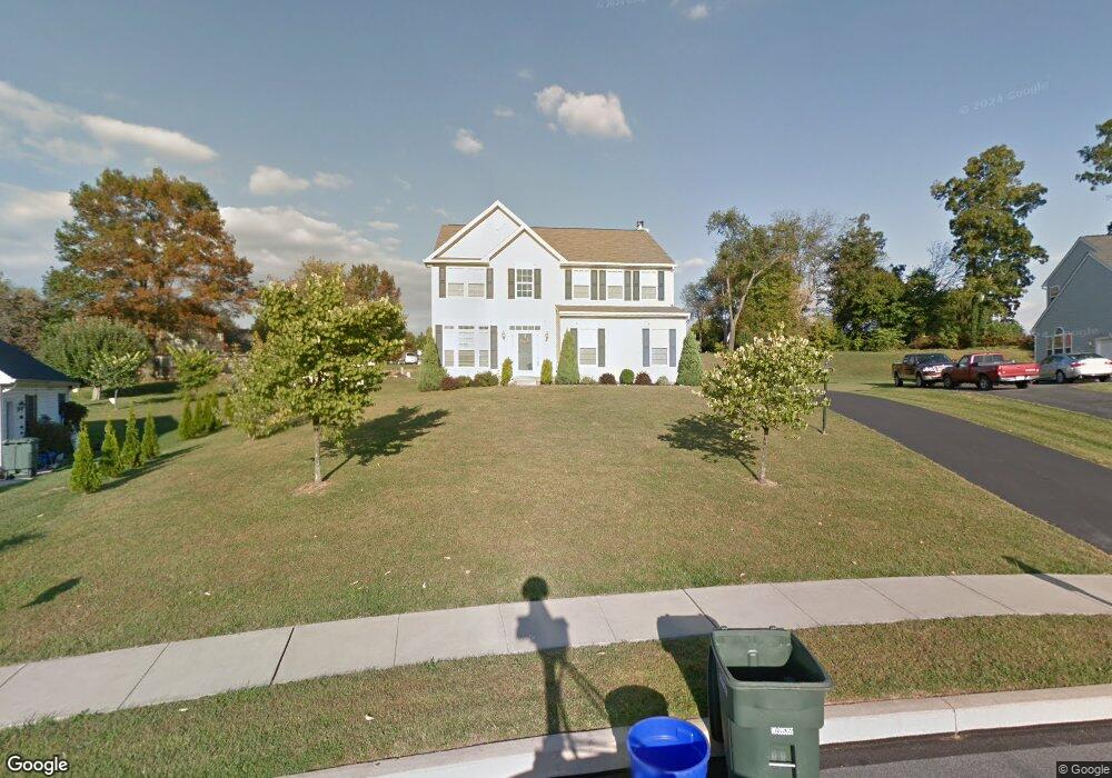
444 Pulaski Place Dallastown, PA 17313
Estimated Value: $382,000 - $505,000
4
Beds
3
Baths
2,660
Sq Ft
$164/Sq Ft
Est. Value
About This Home
This home is located at 444 Pulaski Place, Dallastown, PA 17313 and is currently estimated at $435,436, approximately $163 per square foot. 444 Pulaski Place is a home located in York County with nearby schools including York Township Elementary School, Dallastown Area Middle School, and Dallastown Area High School.
Ownership History
Date
Name
Owned For
Owner Type
Purchase Details
Closed on
Jan 28, 2011
Sold by
Kresslein Robert William and Kresslein Brandy Michele
Bought by
Lewis Fitzroy
Current Estimated Value
Home Financials for this Owner
Home Financials are based on the most recent Mortgage that was taken out on this home.
Original Mortgage
$243,564
Outstanding Balance
$164,433
Interest Rate
4.5%
Mortgage Type
FHA
Estimated Equity
$271,003
Purchase Details
Closed on
Apr 26, 2006
Sold by
Southern Heights Tract Inc
Bought by
Kresslein Ii Robert William and Kresslein Brandy Michele
Home Financials for this Owner
Home Financials are based on the most recent Mortgage that was taken out on this home.
Original Mortgage
$220,000
Interest Rate
6.25%
Mortgage Type
Purchase Money Mortgage
Create a Home Valuation Report for This Property
The Home Valuation Report is an in-depth analysis detailing your home's value as well as a comparison with similar homes in the area
Home Values in the Area
Average Home Value in this Area
Purchase History
| Date | Buyer | Sale Price | Title Company |
|---|---|---|---|
| Lewis Fitzroy | $249,900 | None Available | |
| Kresslein Ii Robert William | $341,620 | Residential Title & Escrow C |
Source: Public Records
Mortgage History
| Date | Status | Borrower | Loan Amount |
|---|---|---|---|
| Open | Lewis Fitzroy | $243,564 | |
| Previous Owner | Kresslein Ii Robert William | $220,000 |
Source: Public Records
Tax History Compared to Growth
Tax History
| Year | Tax Paid | Tax Assessment Tax Assessment Total Assessment is a certain percentage of the fair market value that is determined by local assessors to be the total taxable value of land and additions on the property. | Land | Improvement |
|---|---|---|---|---|
| 2025 | $7,560 | $220,240 | $32,960 | $187,280 |
| 2024 | $7,450 | $220,240 | $32,960 | $187,280 |
| 2023 | $7,450 | $220,240 | $32,960 | $187,280 |
| 2022 | $7,206 | $220,240 | $32,960 | $187,280 |
| 2021 | $6,865 | $220,240 | $32,960 | $187,280 |
| 2020 | $6,865 | $220,240 | $32,960 | $187,280 |
| 2019 | $6,843 | $220,240 | $32,960 | $187,280 |
| 2018 | $6,797 | $220,240 | $32,960 | $187,280 |
| 2017 | $6,526 | $220,240 | $32,960 | $187,280 |
| 2016 | $0 | $220,240 | $32,960 | $187,280 |
| 2015 | -- | $220,240 | $32,960 | $187,280 |
| 2014 | -- | $220,240 | $32,960 | $187,280 |
Source: Public Records
Map
Nearby Homes
- 79 S Franklin St
- 53 S Franklin St
- 263 W Main St
- 0 Lot 15 Gary Dr
- 18 E Howard St
- 2981 Sunset Dr
- 2960 Starfire Dr
- 117 S Park St
- 430 E Maple St
- 680 Hampstead Ct
- 197 S Main St
- 705 Summit Dr
- 1 N Duke St
- 74 S Main St
- 55 Belmar Dr
- 141 W Water St
- 195 Coventry Rd
- 2900 Ironstone Hill Rd
- 630 Woodland Ave
- 114 Heather Glen Dr
- 448 Pulaski Place
- 448 Ridgeford Rd
- 442 Ridgeford Rd
- 440 Pulaski Place
- 452 Ridgeford Rd
- 455 Pulaski Place
- 445 Pulaski Place
- 436 Ridgeford Rd
- 452 Pulaski Place
- 465 Pulaski Place
- 436 Pulaski Place
- 447 Ridgeford Rd
- 112 Teila Dr
- 106 Teila Dr Unit 134
- 106 Teila Dr
- 456 Pulaski Place
- 441 Ridgeford Rd
- 430 Ridgeford Rd
- 435 Ridgeford Rd
- 118 Teila Dr