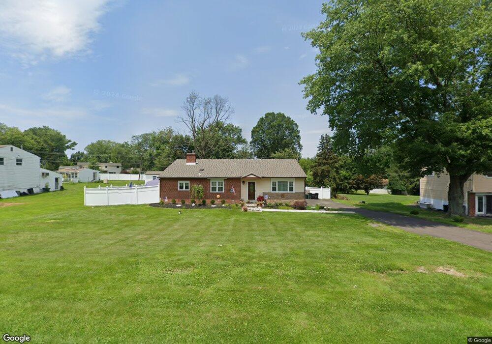
446 Buck Rd Southampton, PA 18966
Estimated Value: $527,000 - $624,000
3
Beds
3
Baths
2,150
Sq Ft
$267/Sq Ft
Est. Value
About This Home
This home is located at 446 Buck Rd, Southampton, PA 18966 and is currently estimated at $573,150, approximately $266 per square foot. 446 Buck Rd is a home located in Bucks County with nearby schools including Holland Elementary School, Holland Middle School, and Council Rock High School - South.
Ownership History
Date
Name
Owned For
Owner Type
Purchase Details
Closed on
Feb 18, 2011
Sold by
Mccullough John J and Mccullough Elizabeth Ann
Bought by
Cruz Kathleen D
Current Estimated Value
Home Financials for this Owner
Home Financials are based on the most recent Mortgage that was taken out on this home.
Original Mortgage
$224,000
Outstanding Balance
$152,109
Interest Rate
4.62%
Mortgage Type
Stand Alone First
Estimated Equity
$421,041
Purchase Details
Closed on
Mar 17, 1995
Sold by
G E Capital Mtg Svcs Inc
Bought by
Obrien Joyce L
Home Financials for this Owner
Home Financials are based on the most recent Mortgage that was taken out on this home.
Original Mortgage
$102,500
Interest Rate
8.8%
Purchase Details
Closed on
Mar 6, 1995
Sold by
Michaels Lawrence R
Bought by
G E Capital Mtg Services Inc
Home Financials for this Owner
Home Financials are based on the most recent Mortgage that was taken out on this home.
Original Mortgage
$102,500
Interest Rate
8.8%
Create a Home Valuation Report for This Property
The Home Valuation Report is an in-depth analysis detailing your home's value as well as a comparison with similar homes in the area
Home Values in the Area
Average Home Value in this Area
Purchase History
| Date | Buyer | Sale Price | Title Company |
|---|---|---|---|
| Cruz Kathleen D | $280,000 | None Available | |
| Obrien Joyce L | $132,500 | First American Title Ins Co | |
| G E Capital Mtg Services Inc | $541 | -- |
Source: Public Records
Mortgage History
| Date | Status | Borrower | Loan Amount |
|---|---|---|---|
| Open | Cruz Kathleen D | $224,000 | |
| Previous Owner | Obrien Joyce L | $102,500 |
Source: Public Records
Tax History Compared to Growth
Tax History
| Year | Tax Paid | Tax Assessment Tax Assessment Total Assessment is a certain percentage of the fair market value that is determined by local assessors to be the total taxable value of land and additions on the property. | Land | Improvement |
|---|---|---|---|---|
| 2025 | $5,393 | $28,000 | $6,120 | $21,880 |
| 2024 | $5,393 | $28,000 | $6,120 | $21,880 |
| 2023 | $5,083 | $28,000 | $6,120 | $21,880 |
| 2022 | $5,036 | $28,000 | $6,120 | $21,880 |
| 2021 | $4,877 | $28,000 | $6,120 | $21,880 |
| 2020 | $4,767 | $28,000 | $6,120 | $21,880 |
| 2019 | $4,563 | $28,000 | $6,120 | $21,880 |
| 2018 | $4,482 | $28,000 | $6,120 | $21,880 |
| 2017 | $4,309 | $28,000 | $6,120 | $21,880 |
| 2016 | $4,309 | $28,000 | $6,120 | $21,880 |
| 2015 | -- | $28,000 | $6,120 | $21,880 |
| 2014 | -- | $28,000 | $6,120 | $21,880 |
Source: Public Records
Map
Nearby Homes
- 131 Rocksville Rd
- 270 Rocksville Rd
- 258 Woodlake Dr
- 100 E Holland Rd
- 537 Ashton Cir
- 527 Ashton Cir
- 6 Rolling Hills Dr
- 29 Langhorne Ave
- 178 Buckshire Dr
- 1502 Chinquapin Rd
- 415 Fox Hollow Dr
- 1 Falcon Dr Unit 203
- 518 Pebble Ridge Ct
- 428 Fox Hollow Dr
- 41 Grant Dr
- 31 W Bellwood Dr
- 2 Falcon Dr Unit 202
- 125 Fox Hollow Dr
- 853 Green Ridge Cir
- 15 Penn Cir