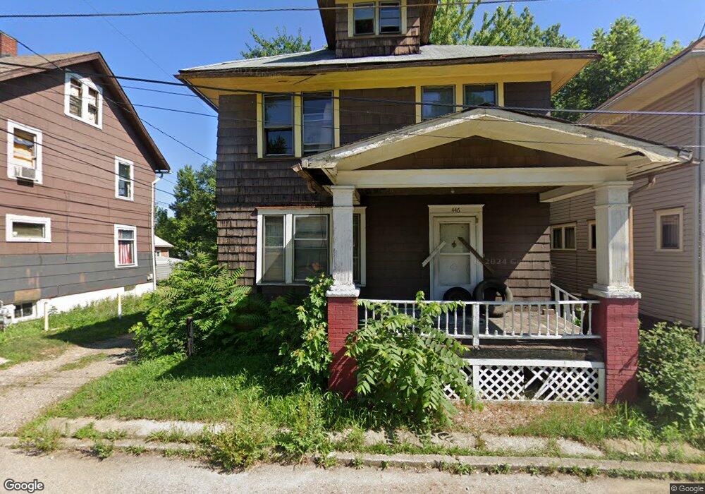
446 Mcnally Ct Alliance, OH 44601
Estimated Value: $61,136 - $86,000
3
Beds
1
Bath
1,248
Sq Ft
$63/Sq Ft
Est. Value
About This Home
This home is located at 446 Mcnally Ct, Alliance, OH 44601 and is currently estimated at $78,034, approximately $62 per square foot. 446 Mcnally Ct is a home located in Stark County with nearby schools including Alliance Intermediate School at Northside, Alliance Elementary School at Rockhill, and Alliance Middle School.
Ownership History
Date
Name
Owned For
Owner Type
Purchase Details
Closed on
Jan 17, 2007
Sold by
Ghattas Reeman
Bought by
446 Mcnally Court Trust
Current Estimated Value
Purchase Details
Closed on
Nov 14, 2006
Sold by
Beneficial Mortgage Co Of Ohio
Bought by
Ghattas Reeman
Purchase Details
Closed on
Jul 20, 2006
Sold by
Gray Lloyd D and Campbell Rodney A
Bought by
Beneficial Mortgage Co Of Ohio
Purchase Details
Closed on
Apr 27, 2001
Sold by
Gray Lloyd D
Bought by
Campbell Rodney A
Home Financials for this Owner
Home Financials are based on the most recent Mortgage that was taken out on this home.
Original Mortgage
$15,662
Interest Rate
6.99%
Mortgage Type
Seller Take Back
Purchase Details
Closed on
Oct 18, 1988
Create a Home Valuation Report for This Property
The Home Valuation Report is an in-depth analysis detailing your home's value as well as a comparison with similar homes in the area
Home Values in the Area
Average Home Value in this Area
Purchase History
| Date | Buyer | Sale Price | Title Company |
|---|---|---|---|
| 446 Mcnally Court Trust | $10,200 | Attorney | |
| Ghattas Reeman | $3,000 | Attorney | |
| Beneficial Mortgage Co Of Ohio | $8,000 | None Available | |
| Campbell Rodney A | $15,662 | -- | |
| -- | $10,000 | -- |
Source: Public Records
Mortgage History
| Date | Status | Borrower | Loan Amount |
|---|---|---|---|
| Previous Owner | Campbell Rodney A | $15,662 |
Source: Public Records
Tax History
| Year | Tax Paid | Tax Assessment Tax Assessment Total Assessment is a certain percentage of the fair market value that is determined by local assessors to be the total taxable value of land and additions on the property. | Land | Improvement |
|---|---|---|---|---|
| 2025 | $4,312 | $4,350 | $1,440 | $2,910 |
| 2024 | $3,688 | $4,350 | $1,440 | $2,910 |
| 2023 | $3,592 | $4,940 | $740 | $4,200 |
| 2022 | $205 | $4,940 | $740 | $4,200 |
| 2021 | $226 | $4,940 | $740 | $4,200 |
| 2020 | $2,797 | $4,100 | $630 | $3,470 |
| 2019 | $180 | $4,100 | $630 | $3,470 |
| 2018 | $181 | $4,100 | $630 | $3,470 |
| 2017 | $158 | $3,510 | $530 | $2,980 |
| 2016 | $169 | $3,510 | $530 | $2,980 |
| 2015 | $80 | $3,510 | $530 | $2,980 |
| 2014 | $94 | $1,970 | $530 | $1,440 |
| 2013 | $47 | $1,970 | $530 | $1,440 |
Source: Public Records
Map
Nearby Homes
- 452 E Summit St
- 726 S Arch Ave
- V/L S Freedom Ave
- 442 S Liberty Ave
- 234 Rosenberry St
- 231 Rosenberry St
- 226 Milner St
- 955 E Summit St
- 935 S Morgan Ave
- 46 Rosenberry St
- 134 11th St
- 807 S Union Ave
- 167 11th St
- 427 S Union Ave
- 361 E Main St
- 62 E Market St
- 1350 S Freedom Ave
- 203 Glamorgan St
- 847 E Patterson St
- 621 S Haines Ave
- 450 Mcnally Ct
- 442 Mcnally Ct
- 649 S Freedom Ave
- 435 Mcnally Ct
- 430 Mcnally Ct
- 440 E Summit St
- 636 S Linden Ave
- 663 S Freedom Ave
- 425 Mcnally Ct
- 650 S Linden Ave
- 621 S Freedom Ave
- 434 E Summit St
- 430 E Summit St
- 683 S Freedom Ave
- 436 E Summit St
- 660 S Linden Ave
- 660 S Freedom Ave
- 666 S Linden Ave
- 656 S Freedom Ave
- 441 E Cambridge St
Your Personal Tour Guide
Ask me questions while you tour the home.