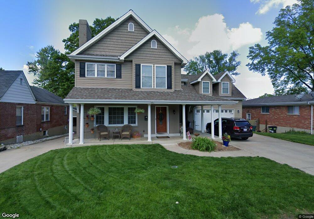
447 Burns Ave Saint Louis, MO 63122
Estimated Value: $796,000 - $1,157,000
5
Beds
4
Baths
3,490
Sq Ft
$261/Sq Ft
Est. Value
About This Home
This home is located at 447 Burns Ave, Saint Louis, MO 63122 and is currently estimated at $909,941, approximately $260 per square foot. 447 Burns Ave is a home located in St. Louis County with nearby schools including W.W. Keysor Elementary School, North Kirkwood Middle School, and Kirkwood Senior High School.
Ownership History
Date
Name
Owned For
Owner Type
Purchase Details
Closed on
Jun 23, 2008
Sold by
Ramming Christopher C
Bought by
Demarco Joseph M and Demarco Carrie M
Current Estimated Value
Home Financials for this Owner
Home Financials are based on the most recent Mortgage that was taken out on this home.
Original Mortgage
$347,500
Outstanding Balance
$222,304
Interest Rate
5.99%
Mortgage Type
Purchase Money Mortgage
Estimated Equity
$687,637
Purchase Details
Closed on
Feb 3, 2005
Sold by
Pickett John William
Bought by
Murphy Kennedy Phyllis J
Home Financials for this Owner
Home Financials are based on the most recent Mortgage that was taken out on this home.
Original Mortgage
$163,508
Interest Rate
5.85%
Mortgage Type
Purchase Money Mortgage
Create a Home Valuation Report for This Property
The Home Valuation Report is an in-depth analysis detailing your home's value as well as a comparison with similar homes in the area
Home Values in the Area
Average Home Value in this Area
Purchase History
| Date | Buyer | Sale Price | Title Company |
|---|---|---|---|
| Demarco Joseph M | $547,500 | None Available | |
| Murphy Kennedy Phyllis J | $164,800 | -- |
Source: Public Records
Mortgage History
| Date | Status | Borrower | Loan Amount |
|---|---|---|---|
| Open | Demarco Joseph M | $347,500 | |
| Previous Owner | Murphy Kennedy Phyllis J | $163,508 |
Source: Public Records
Tax History Compared to Growth
Tax History
| Year | Tax Paid | Tax Assessment Tax Assessment Total Assessment is a certain percentage of the fair market value that is determined by local assessors to be the total taxable value of land and additions on the property. | Land | Improvement |
|---|---|---|---|---|
| 2025 | $7,751 | $90,650 | $46,800 | $43,850 |
| 2024 | $7,751 | $124,090 | $28,080 | $96,010 |
| 2023 | $7,630 | $124,090 | $28,080 | $96,010 |
| 2022 | $8,166 | $123,950 | $28,080 | $95,870 |
| 2021 | $8,059 | $123,950 | $28,080 | $95,870 |
| 2020 | $7,040 | $104,070 | $24,950 | $79,120 |
| 2019 | $7,064 | $104,070 | $24,950 | $79,120 |
| 2018 | $6,834 | $88,910 | $18,720 | $70,190 |
| 2017 | $6,825 | $88,910 | $18,720 | $70,190 |
| 2016 | $6,356 | $83,430 | $18,720 | $64,710 |
| 2015 | $6,325 | $83,430 | $18,720 | $64,710 |
| 2014 | $7,565 | $97,690 | $9,990 | $87,700 |
Source: Public Records
Map
Nearby Homes
- 446 Way Ave
- 523 W Washington Ave
- 427 Central Place
- 537 Goethe Ave
- 456 Wilcox Ave
- 699 W Washington Ave
- 450 W Adams Ave Unit 18
- 216 W Essex Ave
- 507 N Clay Ave
- 243 W Jefferson Ave Unit 4
- 444 N Clay Ave Unit 3F
- 812 Cleveland Ave
- 144 W Adams Ave Unit 3
- 144 W Adams Ave Unit 1W
- 841 N Geyer Rd
- 823 N Harrison Ave
- 102 E Bodley Ave Unit 204
- 522 N Kirkwood Rd Unit 2B
- 936 Poinsetta Ln
- 231 W Monroe Ave Unit 205
- 451 Burns Ave
- 443 Burns Ave
- 455 Burns Ave
- 450 Longfellow Ave
- 444 Longfellow Ave
- 459 Burns Ave
- 439 Burns Ave
- 454 Longfellow Ave
- 418 Longfellow Ave
- 450 Burns Ave
- 446 Burns Ave
- 458 Longfellow Ave
- 456 Burns Ave
- 463 Burns Ave
- 435 Burns Ave
- 412 Longfellow Ave
- 440 Burns Ave
- 464 Longfellow Ave
- 460 Burns Ave
- 408 Longfellow Ave