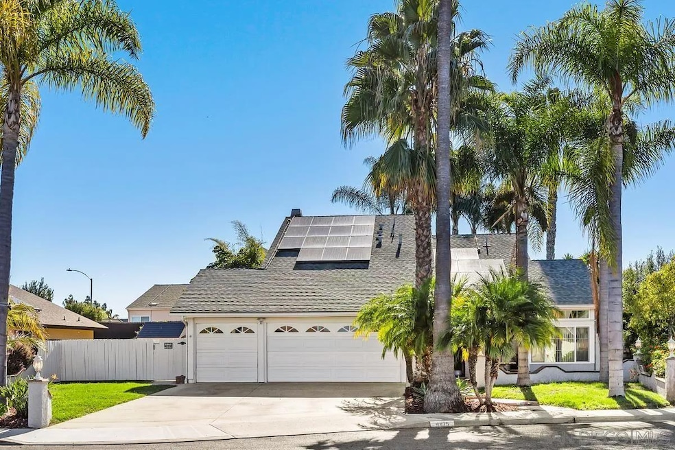
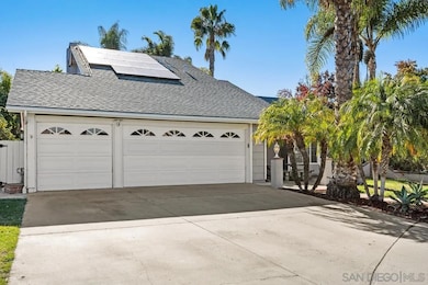
4475 Saint Andrews Place Oceanside, CA 92057
North Valley NeighborhoodEstimated payment $5,838/month
Highlights
- Very Popular Property
- Solar Power System
- Main Floor Bedroom
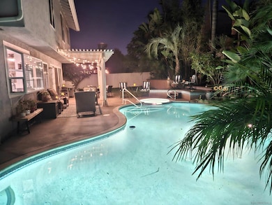
- In Ground Pool
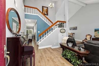
- Vaulted Ceiling
- Breakfast Area or Nook
About This Home
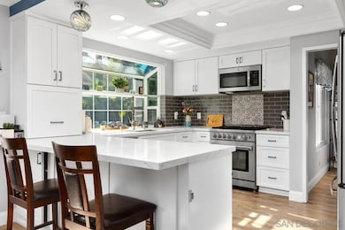
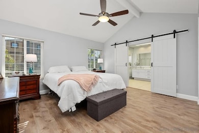
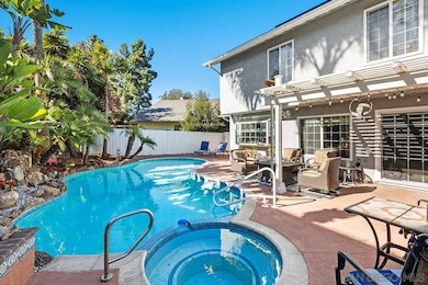
Welcome to 4475 Saint Andrews Place — a beautifully updated 4-bed, 3-bath pool home tucked into a quiet cul-de-sac with no HOA. This two-story residence offers 2,127 sq. ft. of comfortable living, including a highly desirable first-floor bedroom and full bath. Inside, you’ll find bright, open living spaces with vaulted ceilings, upgraded flooring, and excellent natural light. The remodeled kitchen features white shaker cabinetry, stunning quartzite countertops, stainless steel appliances, a spacious island, and a greenhouse window overlooking the backyard. The family room offers a cozy fireplace and easy access to the outdoor entertaining area. Upstairs, the generous primary suite includes vaulted ceilings, dual barn doors leading to the ensuite bath, dual sinks, and ample closet space. Two additional bedrooms and a full bath complete the upper level. The backyard is a standout feature—your own private retreat with a sparkling pool and spa, tropical landscaping, multiple seating areas, and plenty of room to relax or entertain. Leased solar provides valuable energy savings year-round. Additional highlights include a three-car garage, cul-de-sac setting, and convenient proximity to parks, shopping, dining, and schools.
Home Details
Home Type
- Single Family
Year Built
- Built in 1981
Lot Details
- Cul-De-Sac
- Property is Fully Fenced
Parking
- 3 Car Attached Garage
- Garage Door Opener
Home Design
- Concrete Roof
Interior Spaces
- 2,127 Sq Ft Home
- 2-Story Property
- Vaulted Ceiling
- Free Standing Fireplace
- Family Room with Fireplace
- Dining Area
- Gas Dryer Hookup
Kitchen
- Breakfast Area or Nook
- Gas Cooktop
- Microwave
- Dishwasher
- Disposal
Bedrooms and Bathrooms
- 4 Bedrooms
- Main Floor Bedroom
Eco-Friendly Details
- Solar Power System
Pool
- In Ground Pool
- In Ground Spa
- Pool Equipment or Cover
Utilities
- Forced Air Heating System
- Heating System Uses Natural Gas
Community Details
- Oceanside Subdivision
Map
Home Values in the Area
Average Home Value in this Area
Tax History
| Year | Tax Paid | Tax Assessment Tax Assessment Total Assessment is a certain percentage of the fair market value that is determined by local assessors to be the total taxable value of land and additions on the property. | Land | Improvement |
|---|---|---|---|---|
| 2025 | $9,511 | $859,507 | $478,263 | $381,244 |
| 2024 | $9,511 | $842,655 | $468,886 | $373,769 |
| 2023 | $9,218 | $826,134 | $459,693 | $366,441 |
| 2022 | $8,301 | $740,000 | $407,000 | $333,000 |
| 2021 | $7,095 | $610,000 | $336,000 | $274,000 |
| 2020 | $6,613 | $580,000 | $320,000 | $260,000 |
| 2019 | $6,217 | $550,000 | $304,000 | $246,000 |
| 2018 | $6,048 | $530,000 | $293,000 | $237,000 |
| 2017 | $71 | $490,000 | $271,000 | $219,000 |
| 2016 | $4,873 | $430,000 | $238,000 | $192,000 |
| 2015 | $4,748 | $425,000 | $236,000 | $189,000 |
| 2014 | $4,348 | $396,000 | $220,000 | $176,000 |
Property History
| Date | Event | Price | List to Sale | Price per Sq Ft |
|---|---|---|---|---|
| 12/11/2025 12/11/25 | For Sale | $959,000 | -- | $451 / Sq Ft |
Purchase History
| Date | Type | Sale Price | Title Company |
|---|---|---|---|
| Grant Deed | -- | Timios Title A Ca Corp | |
| Quit Claim Deed | -- | None Available | |
| Grant Deed | $629,000 | Chicago Title | |
| Grant Deed | $216,000 | South Coast Title Company | |
| Interfamily Deed Transfer | -- | -- | |
| Grant Deed | $169,500 | South Coast Title Company | |
| Deed | $212,500 | -- | |
| Deed | $140,000 | -- | |
| Deed | $140,000 | -- |
Mortgage History
| Date | Status | Loan Amount | Loan Type |
|---|---|---|---|
| Open | $487,000 | New Conventional | |
| Previous Owner | $503,200 | Stand Alone First | |
| Previous Owner | $216,000 | Stand Alone First | |
| Previous Owner | $172,890 | VA |
Source: San Diego MLS
MLS Number: 250045633
APN: 157-520-02
Disclaimer: Certain information contained herein is derived from information provided by parties other than Homes.com. All information provided is deemed reliable, but is not guaranteed to be accurate and should be independently verified.
![]() This information is deemed reliable but not guaranteed. You should rely on this information only to decide whether or not to further investigate a particular property.
This information is deemed reliable but not guaranteed. You should rely on this information only to decide whether or not to further investigate a particular property.
BEFORE MAKING ANY OTHER DECISION, YOU SHOULD PERSONALLY INVESTIGATE THE FACTS (e.g. square footage and lot size) with the assistance of an appropriate professional. You may use this information only to identify properties you may be interested in investigating further. All uses except for personal, noncommercial use in accordance with the foregoing purpose are prohibited. Redistribution or copying of this information, any photographs or video tours is strictly
prohibited. This information is derived from the Internet Data Exchange (IDX) service provided by San Diego MLS. Displayed property listings may be held by a brokerage firm other than the broker and/or agent responsible for this display. The information and any photographs and video tours and the compilation from which they are derived is protected by copyright. Compilation © 2025 San Diego MLS.
- 233 Festival Dr
- 4499 Pebble Beach Dr
- 4418 Jill St
- 638 Sumner Way Unit 2
- 175 Avenida Descanso Unit 205
- 4569 Calle Del Palo
- 4273 Rockport Bay Way
- 4556 Mariners Bay
- 231 Riverview Way
- 4660 N River Rd Unit 150
- 4660 N River Rd Unit 116
- 4660 N River Rd Unit 17
- 0 N River Rd Unit NDP2507519
- 183 Plumosa St
- 1 Calle Mariposa
- 514 Calle Montecito Unit 78
- 502 Calle Montecito Unit 19
- 4596 Coronado Dr
- 506 Calle Montecito Unit 34
- 517 Calle Montecito Unit 91
- 175 Avenida Descanso Unit avenida descanso
- 4398 Rainier Way
- 4546 Big Sur St Unit 2
- 4628 Marblehead Bay Dr
- 514 Calle Montecito
- 4750 Calle Las Positas
- 505 Calle Montecito Unit 22
- 3784 Nectarine Cir
- 4326 Wind River Way
- 4353 Saddlehorn Way
- 4871 Marblehead Bay Dr
- 4443 Estada Dr Unit B
- 514 Luna Dr
- 377-479 Vandegrift Blvd
- 266 N El Camino Real
- 4213 La Casita Way Unit 2
- 4218 Fiesta Way Unit 3
- 612 Los Arbolitos Blvd
- 601 Hunter St
- 550 Los Arbolitos Blvd
