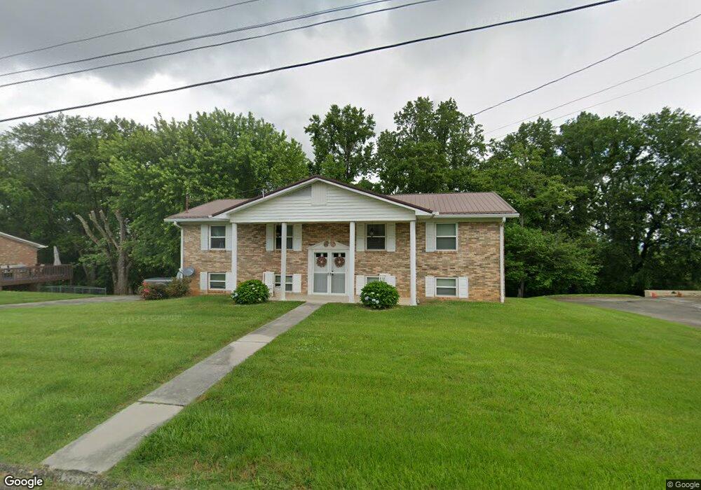
4477 Brockland Dr Morristown, TN 37813
Estimated Value: $235,698 - $291,000
--
Bed
2
Baths
1,350
Sq Ft
$195/Sq Ft
Est. Value
About This Home
This home is located at 4477 Brockland Dr, Morristown, TN 37813 and is currently estimated at $262,925, approximately $194 per square foot. 4477 Brockland Dr is a home located in Hamblen County with nearby schools including John Hay Elementary School, Meadowview Middle School, and Morristown East High School.
Ownership History
Date
Name
Owned For
Owner Type
Purchase Details
Closed on
Feb 25, 2011
Sold by
Lee Joe E
Bought by
Lee Joe E Jr Life Estate
Current Estimated Value
Purchase Details
Closed on
Jan 26, 1993
Bought by
Lee Joe E and Lee Athen
Purchase Details
Closed on
Apr 15, 1991
Bought by
Messer M C
Purchase Details
Closed on
Jan 25, 1979
Bought by
Hodges Charles Oscar and Hodges Brenda
Create a Home Valuation Report for This Property
The Home Valuation Report is an in-depth analysis detailing your home's value as well as a comparison with similar homes in the area
Home Values in the Area
Average Home Value in this Area
Purchase History
| Date | Buyer | Sale Price | Title Company |
|---|---|---|---|
| Lee Joe E Jr Life Estate | $69,600 | -- | |
| Lee Joe E | $64,500 | -- | |
| Messer M C | $60,000 | -- | |
| Hodges Charles Oscar | -- | -- |
Source: Public Records
Tax History Compared to Growth
Tax History
| Year | Tax Paid | Tax Assessment Tax Assessment Total Assessment is a certain percentage of the fair market value that is determined by local assessors to be the total taxable value of land and additions on the property. | Land | Improvement |
|---|---|---|---|---|
| 2024 | $603 | $30,600 | $4,475 | $26,125 |
| 2023 | $603 | $30,600 | $0 | $0 |
| 2022 | $603 | $30,600 | $4,475 | $26,125 |
| 2021 | $603 | $30,600 | $4,475 | $26,125 |
| 2020 | $603 | $30,600 | $4,475 | $26,125 |
| 2019 | $583 | $27,375 | $4,475 | $22,900 |
| 2018 | $583 | $27,375 | $4,475 | $22,900 |
| 2017 | $583 | $27,375 | $4,475 | $22,900 |
| 2016 | $545 | $27,375 | $4,475 | $22,900 |
| 2015 | $506 | $27,375 | $4,475 | $22,900 |
| 2014 | -- | $27,375 | $4,475 | $22,900 |
| 2013 | -- | $30,950 | $0 | $0 |
Source: Public Records
Map
Nearby Homes
- 4458 Brockland Dr
- 670 Jones Franklin Rd
- 4705 E Hampton Blvd
- 4581 Lockley Ct
- 4270 Brockland Dr
- 358 Dover Rd
- 288 Fuller Estate Cir
- 4510 Westover Place
- 4907 Barton Springs Dr
- 1148 George Byrd Rd
- 1342 Slop Creek Rd
- 00 Shinbone E Sugar Hollow Rd
- 3661 Halifax Cir
- 1689 Carroll Rd
- 4027 White Wood Cir
- 1496 Dover Rd
- 4271 Stansberry Rd
- 5085 Old Kentucky Rd
- 4091 White Wood Cir
- 4487 Brockland Dr
- 4478 Brockland Dr
- 4467 Brockland Dr
- 4468 Brockland Dr
- 4495 Brockland Dr
- 4457 Brockland Dr
- 1040 Granby Dr
- 4499 Brockland Dr
- 4447 Brockland Dr
- 4516 Whitecliff St
- 1032 Granby Dr
- 4465 Brockwood Dr
- 4475 Brockwood Dr
- 4455 Brockwood Dr
- 4482 Whitecliff St
- 4448 Brockland Dr
- 4503 Brockland Dr
- 4437 Brockland Dr
- 4445 Brockwood Dr
- 4485 Brockwood Dr