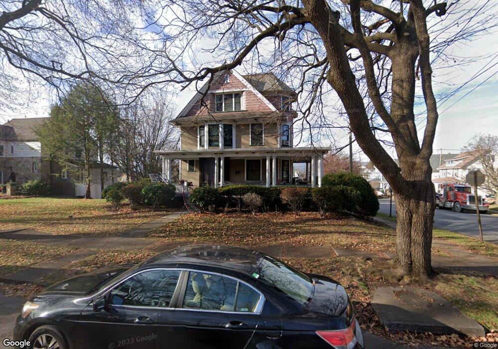
449 Arthur Ave Scranton, PA 18510
Hill Section NeighborhoodEstimated Value: $294,000 - $546,689
6
Beds
3
Baths
3,250
Sq Ft
$129/Sq Ft
Est. Value
About This Home
This home is located at 449 Arthur Ave, Scranton, PA 18510 and is currently estimated at $419,672, approximately $129 per square foot. 449 Arthur Ave is a home located in Lackawanna County with nearby schools including John G. Whittier Elementary School, South Scranton Intermediate, and Scranton High School.
Ownership History
Date
Name
Owned For
Owner Type
Purchase Details
Closed on
Mar 25, 2011
Sold by
Osborne Pamela R
Bought by
Mccann Michael and Mccann Kristin E
Current Estimated Value
Home Financials for this Owner
Home Financials are based on the most recent Mortgage that was taken out on this home.
Original Mortgage
$265,050
Outstanding Balance
$184,499
Interest Rate
5.07%
Mortgage Type
New Conventional
Estimated Equity
$235,173
Purchase Details
Closed on
Mar 18, 2011
Sold by
Osborne Robert J and Osborne Pamela R
Bought by
Osborne Pamela R
Home Financials for this Owner
Home Financials are based on the most recent Mortgage that was taken out on this home.
Original Mortgage
$265,050
Outstanding Balance
$184,499
Interest Rate
5.07%
Mortgage Type
New Conventional
Estimated Equity
$235,173
Purchase Details
Closed on
Jul 2, 2009
Sold by
Osborne Robert J and Osborne Pamela R
Bought by
Osborne Pamela R
Create a Home Valuation Report for This Property
The Home Valuation Report is an in-depth analysis detailing your home's value as well as a comparison with similar homes in the area
Home Values in the Area
Average Home Value in this Area
Purchase History
| Date | Buyer | Sale Price | Title Company |
|---|---|---|---|
| Mccann Michael | $279,000 | None Available | |
| Osborne Pamela R | -- | None Available | |
| Osborne Pamela R | -- | None Available |
Source: Public Records
Mortgage History
| Date | Status | Borrower | Loan Amount |
|---|---|---|---|
| Open | Mccann Michael | $265,050 |
Source: Public Records
Tax History
| Year | Tax Paid | Tax Assessment Tax Assessment Total Assessment is a certain percentage of the fair market value that is determined by local assessors to be the total taxable value of land and additions on the property. | Land | Improvement |
|---|---|---|---|---|
| 2025 | $7,499 | $20,000 | $8,600 | $11,400 |
| 2024 | $6,924 | $20,000 | $8,600 | $11,400 |
| 2023 | $6,924 | $20,000 | $8,600 | $11,400 |
| 2022 | $6,774 | $20,000 | $8,600 | $11,400 |
| 2021 | $6,774 | $20,000 | $8,600 | $11,400 |
| 2020 | $6,667 | $20,000 | $8,600 | $11,400 |
| 2019 | $6,294 | $20,000 | $8,600 | $11,400 |
| 2018 | $6,294 | $20,000 | $8,600 | $11,400 |
| 2017 | $6,200 | $20,000 | $8,600 | $11,400 |
| 2016 | $2,576 | $20,000 | $8,600 | $11,400 |
| 2015 | $4,517 | $20,000 | $8,600 | $11,400 |
| 2014 | -- | $20,000 | $8,600 | $11,400 |
Source: Public Records
Map
Nearby Homes
- 0 Colfax Ave
- 617 Arthur Ave
- 619 Arthur Ave
- 516 Harrison Ave
- 342 Harrison Ave
- 616-618 Harrison Ave
- 1513 1515 Vine St
- 7 Oakwood Place
- 0 Colfax and Gibson Ave Unit GSBSC255175
- 1019 Moosic St
- 432 Taylor Ave
- 529 Taylor Ave
- 900 Wheeler Ave
- 1947 Myrtle St
- 550 Clay Ave Unit 8C
- 929 Ridge Ave
- 217 Crown Ave
- 910 Orchard St
- 2211 Ash St
- 315 Stafford Ave
- 1810 Vine St
- 437 Arthur Ave
- 425 Arthur Ave
- 1812 Vine St
- 1812 Vine St Unit 1812
- 501 Arthur Ave
- 1808 Vine St
- 0 Arthur Ave
- 503 Arthur Ave
- 1809 Vine St
- 423 Arthur Ave
- 442 Colfax Ave
- 1807 Vine St
- 438 Colfax Ave
- 511 Arthur Ave
- 421 Arthur Ave
- 448 Colfax Ave
- 509 Arthur Ave Unit Arthur-57134
- 509 Arthur Ave
- 436 Colfax Ave Unit 438
Your Personal Tour Guide
Ask me questions while you tour the home.